 MineArchive
Dolfrwynog Mine
| Location | Capel Hermon, Coed y Brenin, north of Dolgellau, Gwynedd — 52.8137, -3.8604 (approximate) |
|---|---|
| Commodities | Copper, Gold |
| Type | Metal |
| Worked | Working by 1824; renewed after 1851–Ceased in or by 1874; Buddlepit records work to 1919 |
| Maximum depth | Unknown. |
Overview
Copper and gold workings around Capel Hermon in Coed y Brenin, the most important copper producer of the Dolgellau district in the first half of the nineteenth century. Rich pockets of gold were found in the 1850s, and the adjoining Turf Copper Mine — unique in Britain — worked copper out of peat.
History
Dolfrwynog is a group of workings in a complicated and dispersed mining area north of Dolgellau, where copper was sought by levels, by deep mining and by extraction from turf. Buddlepit records work at various times between 1851 and 1919, with 1,542 tons of copper concentrate between 1824 and 1847 the only recorded output; the Geological Conservation Review calls the group about Capel Hermon, known as the Dolfrwynog Mine, the most important copper producer in the district in the first half of the nineteenth century, with several rich pockets of gold found in the 1850s and mining finished by the end of the 1860s. The Heneb historic environment record for North Dolfrwynog, complicated by several different outfits working different parts of the sett, has work beginning again after 1851 and ceasing in or by 1874, and notes that production was overshadowed by promotion. The veins strike north-east to south-west, carrying chalcopyrite, pyrite and arsenopyrite in a quartz gangue, with a more easterly lode to the north carrying gold with pyrite and chalcopyrite. Heneb records adits at SH 7418 2540 and SH 7428 2533 and a shaft at SH 7469 2567, since filled with domestic rubbish, large enough to have held pump rods for the steam engine installed to pump. A pan amalgamation plant was in existence by 1855, when a new mill was commissioned, driven by an overshot water-wheel and thought to have stood at SH 7488 2557 where a bungalow now is; its chimney was demolished in the 1930s to build Pont Hermon. Beside the vein workings lay the Turf Copper Mine, where copper-rich peat was stripped, burnt in a kiln and the ashes smelted — a practice unique in the British Isles, and the reason the ground is now protected for its copper-tolerant vegetation.
Geology
North-east to south-west striking veins with massive quartz, pyrite and some chalcopyrite, plus arsenopyrite, with a more easterly gold-bearing lode to the north. The workings lie in the Coed y Brenin porphyry copper system, where copper was also remobilised and reprecipitated into a peat bog in Holocene times — the deposit worked as the Turf Copper Mine.
Workings
Levels, a shaft and deep mining on the veins, with adits recorded at SH 7418 2540 and SH 7428 2533 and a shaft at SH 7469 2567; a pan amalgamation plant by 1855 with a new water-powered mill, and a steam engine for pumping. The adjoining turf workings stripped copper-bearing peat for burning and smelting.
Closure
Heneb records work ceasing in or by 1874, and the Geological Conservation Review says mining had ceased by the end of the 1860s; Buddlepit gives the working span as 1851 to 1919, which may cover later trials on parts of the sett.
What remains
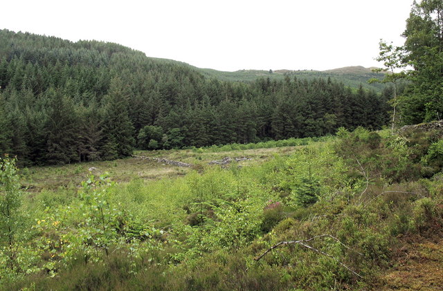
A 2007 Geograph photograph shows the mine's site as a forest clearing with scant ruins among bracken and scrub in Coed y Brenin; the turf ground is a Site of Special Scientific Interest for its copper-tolerant vegetation, and the mill site is occupied by a bungalow. The shaft recorded by Heneb was found filled with domestic rubbish.
Ruins in a forest clearing, the traces of what may be a leat at SH 7472 2560, and a filled shaft; the 1855 mill's chimney was demolished in the 1930s and its site built on.
Redevelopment
The area is Forestry Commission plantation, Coed y Brenin, with the turf ground protected as an SSSI.
Nearby mines
- Gwynfynydd Gold Mine — 0.3 km W
- Turf Copper Mine — 0.6 km W
- Cefn Coch Gold Mine — 0.8 km SW
- Tyddyn Gwladys Mine — 1.6 km NW
- Glasdir Mine — 6.3 km SW
Straight-line distance, within 15 km. Show on the map.
What's uncertain
Points where sources disagree or the record could not be settled; both accounts are kept. All open questions in the archive.
- Several rich pockets of gold were found at the site in the 1850s, and mining had ceased by the end of the 1860s according to the GCR, or in or by 1874 according to Heneb. (disputed) 3,1
Recorded claims
Individual factual claims, each attached to the source(s) that support it below. Where sources disagree, both are kept.
- The Geological Conservation Review describes the group of workings about Capel Hermon, known as the Dolfrwynog Mine, as the most important copper producer in the district in the first half of the nineteenth century. 1
- Buddlepit records work at various times between 1851 and 1919, with 1,542 tons of copper concentrate between 1824 and 1847 the only recorded output, and says promotion activities overshadowed production. 2
- Several rich pockets of gold were found at the site in the 1850s, and mining had ceased by the end of the 1860s according to the GCR, or in or by 1874 according to Heneb. (disputed) 3,1
- Heneb records adits at SH 7418 2540 and SH 7428 2533, a shaft at SH 7469 2567 filled with domestic rubbish, a pan amalgamation plant by 1855 with a new water-powered mill, and a steam engine installed to pump. 3
- At the adjoining Turf Copper Mine copper-rich peat was stripped, burnt in a kiln and the ashes smelted — a site the GCR calls unique in the British Isles; the ground is now an SSSI for its copper-tolerant vegetation. 1,4
Photographs & further reading
The historic environment record for the northern sett, with grid references for the adits, shaft and mill site.
View sourceDates, recorded output, coordinates and a bibliography of sixteen published accounts of the mine.
View sourceSources
- (secondary) Coed y Brenin Porphyry Copper System (Geological Conservation Review) — GeoGuide / GCR
- (secondary) Dolfrwynog (Buddlepit mine database) — Buddlepit
- (primary) North Dolfrwynog Mine, Ganllwyd (Heneb HER PRN 21870) — Heneb Historic Environment Record
- (observational) Forest clearing with the ruins of a copper mine (Geograph photo 501807, 2007) — Geograph
Record created: 17 September 2026 · Last researched: 17 September 2026