 MineArchive
Darnley Lime Works
| Also known as | Darnley Lime and Fireclay Works, Darnley Quarry |
|---|---|
| Location | Darnley, south-west of Glasgow — 55.8070, -4.3482 (exact) |
| Commodities | Limestone, Fireclay |
| Type | Quarry |
| Worked | By 1610–c. 1959 |
| Maximum depth | Open quarries with associated mines; no depth is recorded. |
Overview
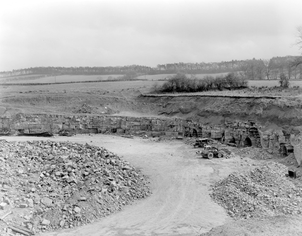
Darnley Lime Works stood on the Brock Burn south-west of Glasgow, on ground now within the Dams to Darnley Country Park. Mining in the area is documented from 1610, when a lease among Sir John Maxwell, John Hall and George Stephenson gave Stephenson the right to work limestone at Over Darnley, and coal was being mined by April 1615 under a contract between Robert Milne and Sir John Maxwell. Limestone came to the kilns from several quarries by a narrow gauge tramway and a probable standard gauge mineral railway, both shown on Ordnance Survey maps and operating at least between 1898 and 1959. By 1914-15 the works had become the Darnley Lime and Fireclay Works and the quarries south of what is now Southpark Village were being described as the Darnley Fireclay Mine.
History
The Darnley ground has one of the earlier documented extraction records in the Glasgow area. A lease of 1610, preserved with the Pollok Estate papers, records Sir John Maxwell, John Hall and George Stephenson agreeing that Stephenson should have the right to mine limestone at Over Darnley; a contract of April 1615 between Robert Milne and Sir John Maxwell shows coal being worked here as well. John Ainslie's map of 1800 shows limestone quarries close to Darnley Mill east of the Brock Burn and two more above Upper Darnley, and marks the mineral railway running south from the lime works to quarries. The second edition Ordnance Survey of 1896-99 shows the quarry Ainslie had recorded — on the site of what is now junction 3 of the M77 — with the tramway running from it to the limestone kilns east of the Brock Burn. By the 1914-15 mapping the activity had grown considerably: field railways ran west of the Brock Burn from the Waulkmill Mine at Waulkmill Glen to cement works north of North Brae Farm, the quarries south of today's Southpark Village had become the Darnley Fireclay Mine, and the works itself was now the Darnley Lime and Fireclay Works.
Geology
The workings took limestone, and later fireclay and coal, from the Carboniferous rocks of the Clyde basin south-west of Glasgow. The combination is characteristic of this ground: limestone for burning to lime, fireclay for refractory goods, and coal both to fire the kilns and to sell. No source gives a detailed stratigraphy for the Darnley quarries.
Geological setting: Sedimentary Beds and Seams (historical documentary reference)
Workings
A dispersed system rather than a single quarry. Limestone was brought to the kilns east of the Brock Burn from more than one working: by a narrow gauge tramway, probably 2 ft, from a quarry face near Arden, and by a probable standard gauge mineral railway that branched into the quarries to the south. The mineral railway was already marked on Ainslie's map of 1800 and ran from the lime works south to quarries beyond what is now Southpark Village, with another quarry west of the point where the Aurs Burn joins the Brock Burn. From Nitshill a siding ran south to the lime works and its tramways. The tramway and railway are recorded as operating at least from 1898 to 1959.
Closure
The tramway and mineral railway are recorded as operating until about 1959. No source gives a precise closure date for the quarries or the lime works themselves.
What remains
The ground is now the Dams to Darnley Country Park. The quarry that the tramway served has been taken by junction 3 of the M77 motorway, and the site of the lime kilns lies just south of the junction of Corselet Road and Nitshill Road. The adits and pits of the fireclay mine have been infilled, and its site is now a grassy field on the east side of Corselet Road, north-east of the country park's main car park.
No structures are recorded as surviving. The line of the tramway and mineral railway can be followed on historic Ordnance Survey mapping rather than on the ground, much of the quarrying having been built over by the motorway and by housing.
Nearby mines
- Victoria Pit, Nitshill — 0.6 miles (0.9 km) NW
- Hurlet Colliery — 0.8 miles (1.2 km) N, Renfrewshire
- Govan Colliery — 3.9 miles (6.2 km) NE
- Aitkenhead Colliery — 4.2 miles (6.7 km) E
- Stonelaw Colliery — 5.5 miles (8.9 km) E, South Lanarkshire
Straight-line distance, within 9 miles (15 km). Show on the map.
What's uncertain
Points where sources disagree or the record could not be settled; both accounts are kept. All open questions in the archive.
- Sources differ on where the works sit. The Scottish Cave and Mine Database gives Darnley Park, Nitshill, City of Glasgow (Renfrewshire); Wikipedia places the tramway and works in East Renfrewshire, 9.7 km south-west of Glasgow. The country park straddles the boundary. (disputed) 1,2
Recorded claims
Individual factual claims, each attached to the source(s) that support it below. Where sources disagree, both are kept.
- A lease agreement of 1610 among Sir John Maxwell, John Hall and George Stephenson, archived with the Pollok Estate papers, gave Stephenson the right to mine limestone at Over Darnley. A contract of April 1615 between Robert Milne and Sir John Maxwell shows coal being mined by that date. 1
- A narrow gauge tramway, probably 2 ft, and a probable standard gauge mineral railway served the lime works, operating at least from 1898 to 1959. The mineral railway was already marked on John Ainslie's map of 1800. 1
- By the 1914-15 Ordnance Survey mapping the quarries south of what is now Southpark Village were described as the Darnley Fireclay Mine and the works as the Darnley Lime and Fireclay Works, with field railways running from the Waulkmill Mine to cement works north of North Brae Farm. 1
- The main Darnley fireclay mine was a modest-scale room-and-pillar complex abandoned in 1920, its abandonment plan carrying survey dates from 1906 to 1919. From the No. 3 shaft the workings ran about 230 m south-west, passing under Corselet Road, about 180 m south-east and about 100 m north. 2
- Fireclay was found in the area in seams up to eight feet thick below the limestone, worked at various times and particularly around 1900. The large fireclay kilns made bricks, pipes and sanitary products. 2
- The Darnley workings, which processed both fireclay and limestone brought from other local quarries, were known over the years as the Upper Darnley Fireclay Mine, Darnley Lime Works and Arden Lime Works. 2
- Sources differ on where the works sit. The Scottish Cave and Mine Database gives Darnley Park, Nitshill, City of Glasgow (Renfrewshire); Wikipedia places the tramway and works in East Renfrewshire, 9.7 km south-west of Glasgow. The country park straddles the boundary. (disputed) 1,2
Photographs & further reading
Records the fireclay mine shaft by shaft from the abandonment plan — the extent of the room-and-pillar workings, the eight-foot fireclay seams below the limestone, the alternative names the works went under, and what has since become of the site.
View sourceTraces the workings through the map record from Ainslie's survey of 1800 to the Ordnance Survey editions of the 1890s and 1910s, and carries the 1610 limestone lease and 1615 coal contract that make this some of the earliest documented extraction near Glasgow.
View sourceSources
- (secondary) Darnley Lime Works Tramway and Mineral Railway — Wikipedia
- (secondary) Darnley Fireclay Mine [1] (No. 3 shaft) — Scottish Cave and Mine Database, Grampian Speleological Group
Record created: 4 September 2026 · Last researched: 4 September 2026