 MineArchive
Craig Rhiwarth Slate Quarries
| Also known as | Rhiwarth Quarry |
|---|---|
| Location | Llangynog, Cwm Pennant, Powys — 52.8278, -3.4031 (exact) |
| Commodity | Slate |
| Type | Slate |
| Worked | By 1705–1940-41 |
| Operators | W. H. Thomas (owner) — Owner in the 1903 accident return |
Hillside and underground slate quarries above Llangynog in the Tanat valley, working by 1705, served by inclines and tramways, and closed for good in 1940-41.
Location
Recorded location. The large pin is this mine; the small round markers are the nearest mines on record. Click one for its page. View on full map
History
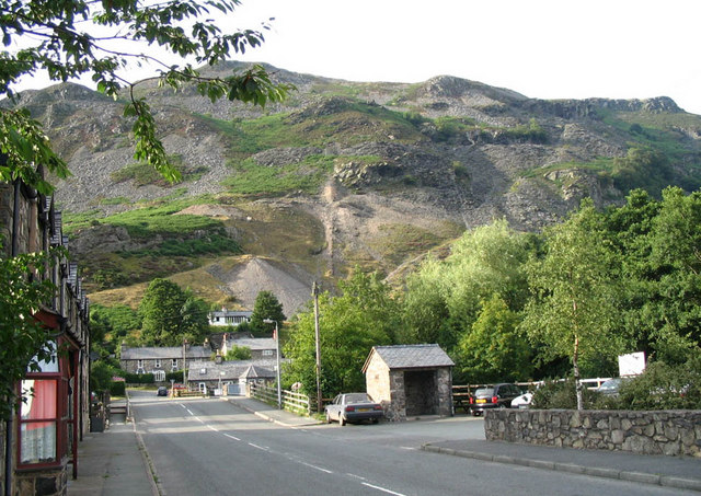
The Craig Rhiwarth slate quarries climb the hillside immediately north of Llangynog in Cwm Pennant. A quarry was working there by 1705, and perhaps as early as the 16th century. In the early days the slate was sledged down to the valley floor, some 800 feet below. The quarry was busy in the first decade of the 19th century, when an incline was put in, and in the middle of the century came a new incline to the west, further galleries and a two-foot gauge tramway; later working went underground. The slate was carted away, possibly for river carriage at first, then to the canal at Llanymynech and, after 1871, to the railhead at Porth-y-waen. Output was 1,000 tons in 1856, and in 1882 fifteen men made 329 tons.
The quarry declined later in the 19th century. There was a brief revival when the Tanat Valley Railway reached Llangynog, and the incline was carried under the road to exchange sidings at the terminus. In 1903, under W. H. Thomas, a miner was killed on the spot when a block of about two tons fell on him from above a tunnel entrance that had just been examined. Men moved here in the 1930s after the West Llangynog quarry closed, and 26 were employed in 1937-38, but the quarry closed for good in 1940-41. It is thought to have shared facilities with the lead mine and the roadstone quarry beside it.
Geology
Slate of the Berwyn hills above the Tanat valley.
Workings
Hillside galleries with some underground workings, two successive inclines and a two-foot gauge tramway; the later incline ran under the road to sidings at the railway terminus.
Closure
Final closure came in 1940-41.
What remains
Disused; the inclines, the ruins of quarry buildings including a magazine, a winder at the head of the first incline and walled-up openings visible from the valley survive.
The inclines and their structures, ruined buildings including a magazine, and the quarry galleries and tips.
Related mines
- West Llangynog Slate Quarry — Men moved from West Llangynog to the Craig Rhiwarth slate quarries when West Llangynog closed in the 1930s (Coflein, NPRN 40609).
Nearby mines
- Llangynog Mine — 0.5 miles (0.8 km) S
- Cwm Orog Lead Mine — 0.6 miles (0.9 km) NW
- West Llangynog Slate Quarry — 0.6 miles (0.9 km) SW
- Craig-y-Mwyn Mine — 1.7 miles (2.7 km) NE
- Cynwyd Forest Quarry — 8.6 miles (13.9 km) N, Denbighshire
Straight-line distance, within 9 miles (15 km).
Further reading
The Royal Commission's site record: the quarry's history from 1705, its inclines, transport, output and final closure in 1940-41.
View sourceA 2021 visit with photographs of the inclines, buildings, winder and workings.
View sourceSources
- (primary) Craig Rhiwarth Slate Quarries, Cwm Pennant (Coflein, NPRN 40609) — RCAHMW
- (secondary) NMRS deaths and injuries database: Rhiwarth Quarry, 1903 — Northern Mine Research Society
- (secondary) NMRS deaths and injuries database: Rhiwarth Quarry, 1939 — Northern Mine Research Society
- (observational) Mines 6: Craig Rhiwarth Slate, Llangynog, November 2021 (28DaysLater) — 28DaysLater
- (observational) Craig Rhiwarth from Berwyn Street, Llangynog (Geograph) — Geograph
- (primary) Ochr (Yr) Stone Quarry; Craig Rhiwarth, Roadstone Quarry (Coflein, NPRN 40614) — RCAHMW
Record created: 20 November 2026 · Last researched: 20 November 2026