 MineArchive
Cop Rake
| Also known as | Wardlow Cop, Copp Rake |
|---|---|
| Location | Bradwell Moor, west of Rake Head to Cop Round, Derbyshire — 53.3171, -1.8033 (approximate) |
| Commodity | Lead |
| Type | Metal |
| Worked | By 1216–by 1880 |
| Operators | Daniel Bradley (1754–1765) — Freed Sheep Hole Grove in 1754 and a taker in 1765 |
A lead rake on Bradwell Moor where three mining liberties meet, worked as the Wardlow Copp mines in 1216-1249 and now a scheduled monument with its open cut and gin circle.
Location
Approximate location. The large pin is this mine; the small round markers are the nearest mines on record. Click one for its page. View on full map
History
Cop Rake is a large lead vein on Bradwell Moor, the northern branch of Moss Rake. It leaves Moss Rake near Rake Head Mine and runs west across a ridge of high ground to Cop Round, then down the hillside through a corner of Castleton liberty into Peak Forest liberty at Starvehouse Mine, joining Oxlow Rake near Bank Top Mine. Three mining liberties, Bradwell, Peak Forest and Castleton, meet on the rake at Cop Round, where the working is recorded as New York Mine. It was at work early. As the Wardlow Copp mines it raised about 9,300 loads (2,325 tons) of ore between 1216 and 1249. Copp Rake was in production again in 1605, and in 1674 a Barmote Court case concerned 40 loads of ore taken from it illegally.
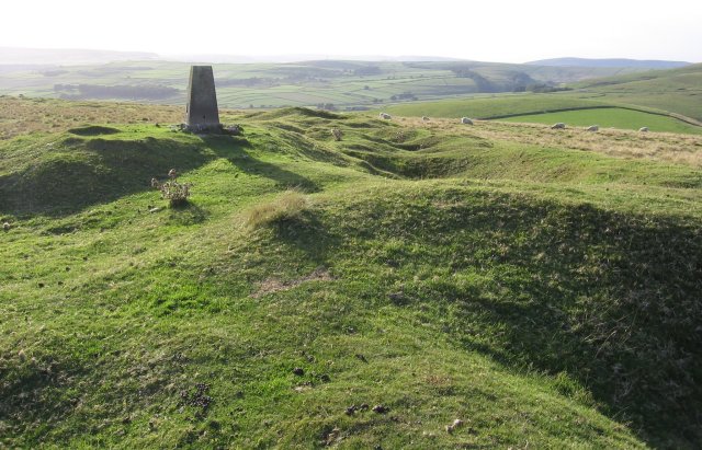
The Bradwell Barmaster recorded few freeings on the rake. In December 1754 Daniel Bradley freed a founder meer called Sheep Hole Grove in the Cop Rake Old Vein and added a taker in 1765; in 1773 Peter Furniss at Cop Grove freed a second taker east from Bradley's old founder. All working had stopped by 1880, when the Ordnance Survey marked the rakes as old lead mining. In Bradwell liberty the rake is a single deep open cut with its waste heaps set back from the edge, a form indicative of thirteenth-century working. Near Cop Round a later group survives: small climbing shafts, a bridge, walling, an engine shaft and a gin circle. The rake and the neighbouring part of Moss Rake were scheduled as an ancient monument in 2000.
Geology
An east-west lead vein crossing the Bee Low Limestones, branching northward from Moss Rake near Rake Head and joining Oxlow Rake to the west; it carried galena.
Workings
In Bradwell liberty a single long, deep open cut worked to daylight, its waste hillocks set back from the edge; near Cop Round small climbing shafts, a bridge, walling, an engine shaft and a gin circle; further east very large waste hillocks and two covered shafts; at the western end, at Starvehouse Mine, well-preserved hillocks and open cuts.
Closure
Working had ceased by 1880, when the Ordnance Survey recorded the rake as old lead mining.
What remains
Well preserved, and protected as a scheduled monument with part of Moss Rake since 2000. Modern reworking for fluorspar near Cop Mine has degraded part of the earlier remains, which lie outside the scheduled area.
Open cuts, hillocks, climbing and capped shafts, drystone bridges across the vein, an engine shaft with a gin circle near Cop Round, and a small water storage or washing pond.
Redevelopment
Parts near Cop Mine were reworked for fluorspar in modern times.
Related mines
- Moss Rake — Cop Rake is the northern branch of Moss Rake, the same vein system, and the two are scheduled together as one monument.
- Oxlow Rake Lead Mines — The veins join: Cop Rake runs west from Bradwell Moor to meet Oxlow Rake near Bank Top Mine, in Peak Forest liberty.
- Rake Head Mine — Cop Rake branches from Moss Rake at Rake Head, and the Little Rake that Joseph Clay worked from Rake Head is probably the eastern end of the same vein.
Nearby mines
- Oxlow Rake Lead Mines — 0.3 miles (0.4 km) NW
- Rake Head Mine — 0.6 miles (0.9 km) E
- Hill's Venture Lead Mine — 0.7 miles (1.1 km) SW
- Hazard Mine — 0.8 miles (1.2 km) NE
- Raddlepits Mine — 0.8 miles (1.3 km) E
Straight-line distance, within 9 miles (15 km). Show on the map.
Further reading
The county's copy of the Historic England scheduling (list entry 1019043), describing the rake's open cuts, shafts, gin circle and the meeting of three liberties.
View sourceThe society's history and gazetteer of the Bradwell lead mines, with the thirteenth-century Wardlow Copp output and the Barmaster's entries for Cop Rake.
View sourceSources
- (primary) A History and Gazetteer of the Lead Mines within Bradwell Liberty (Bulletin 17-5) — Peak District Mines Historical Society / J.H. Rieuwerts
- (secondary) DDR6935 - Scheduled Monument: Cop Rake and Moss Rake lead mines 750m north east of Wheston House — Derbyshire Historic Environment Record
Record created: 18 November 2026 · Last researched: 18 November 2026