 MineArchive
Carnlough Limestone Quarries
| Also known as | Gortin Quarry, Carnlough Quarries |
|---|---|
| Location | Gortin (Croft Road) quarry and neighbouring quarries west and south of Carnlough, Glens of Antrim, County Antrim — 54.9988, -6.0073 (approximate) |
| Commodity | Limestone |
| Type | Quarry |
| Worked | Before 1808; Londonderry scheme 1853-54–About 1922 (railways) |
| Maximum depth | Unknown. |
| Operators | Marquess of Londonderry (1853–1864), Carnlough Lime Company |
Overview
Limestone quarries above Carnlough on the Antrim coast, whose stone was shipped to Scotland as flux for the Clyde's iron furnaces. In the 1850s the Marquess and Marchioness of Londonderry, owners of the Seaham collieries, built a new harbour, a self-acting incline railway through the village on a stone bridge, and lime kilns to work them. The railways ran until about 1922, and the line from the harbour to Cranny Falls is now a footpath.
History
Limestone had long been shipped from Carnlough in small craft, bartered in Scotland for coal, from a loose-stone pier built in the late 18th century by Phillip Gibbons; by 1808 a gravity incline, a 'hurry', brought stone down from the quarries to the road. Frances Anne Vane, Marchioness of Londonderry, inherited the Carnlough estate in 1834. She and her husband, the 3rd Marquess, had built Seaham Harbour for their Durham coal and knew the Cleveland iron trade, and they aimed the Carnlough scheme at the fast-growing demand for limestone flux on the Clyde. Work began late in 1853 under their agent Richard Wilson, with an engineer, Hunt, from Seaham and the contractor Patrick Mahon. A new basin and south pier were built, and an incline railway ran about three-quarters of a mile from the quarry to chutes on the quay, crossing the main street on the Arches; the inscription on the bridge records it as begun by the Marquess and finished by the Marchioness in 1854, after his death. The first cargo left the new quay on 8 August 1854, bringing an order for 10,000 tons from Tennent of Glasgow. The scheme was dogged by trouble: a rock bar and then a sand bar at the entrance kept loaded ships out, horses were needed on the lower incline until Robert Watson, another Seaham engineer, made it self-acting in 1856, and part of the south pier carrying the railway collapsed in February 1860. By May 1856 over 2,600 tons had gone to Glasgow that year and Wilson could not find quarrymen fast enough. Lime burning began in August 1857 in kilns Watson built, soon five of them, selling fertiliser inland. Richard Halloran became manager in 1860 and from 1 February 1864 leased the whole concern, quarries included, at £500 a year. Later the railway was worked by the Carnlough Lime Company and extended to several quarries and a whiting works; Geograph's notes describe three quarries west and south of the village linked to the harbour by lines of 3 ft 6 in and 4 ft 8½ in gauge, working from 1853 to 1922.
Geology
Limestone, shipped as blast-furnace flux and burned for agricultural lime; the sources read give no further geological detail.
Workings
Open quarries above the village; a self-acting cable incline, with loaded wagons drawing up the empties, ran down through a 200-yard cutting and over the Arches to chutes on the south pier. Later lines of 3 ft 6 in and standard gauge linked three quarries, the kilns, a mill and a whiting works to the harbour.
Closure
The quarry railways are recorded as operating from 1853 to 1922; a later account says the workings have been abandoned for over eighty years. No closure date is given for the quarries themselves.
What remains
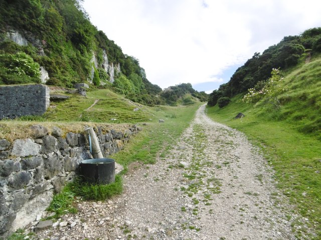
The Gortin quarry is disused, with its face, outbuildings and spoil heap still visible; the railway bed from the harbour to Cranny Falls is a footpath and wildlife area.
Quarry faces and outbuildings, the limestone railway bridges (the Arches) over Harbour Road and the main street, the Herbert Street lime kilns and the 1854 harbour.
Redevelopment
The harbour is used by leisure craft and tours; the railway bed is a walking route to Cranny Falls.
Nearby mines
- Glenariff Iron Ore Mines — 7.0 km NW
- Glenravel Iron and Bauxite Mines — 11.5 km W
- Tievebulliagh Axe Factory — 11.5 km NW
Straight-line distance, within 15 km. Show on the map.
People
- Phillip Gibbons (d. 1815) · landowner, to 1815 — Built the loose-stone pier from which Carnlough limestone was shipped before the Londonderry harbour.
- Richard Halloran · lessee, 1860–1864 — Manager of the Carnlough lime kilns from 1860 and lessee of the whole concern, quarries included, from 1864.
- Patrick Mahon · contractor, 1853–1856 — Contractor who built Carnlough harbour and the town hall.
- Charles William Vane (1778–1854) · owner, 1850–1854 — Planned the Carnlough harbour and quarry railway; died in March 1854 before its completion.
- Frances Anne Vane (d. 1865) · owner, 1834–1865 — Inherited the Carnlough estate in 1834 and completed the harbour, railway and quarry scheme after her husband's death in 1854.
- Robert Watson · engineer, 1856–1860 — Seaham engineer who made the quarry incline self-acting in 1856, built the lime kilns and repaired the south pier in 1860.
- Richard Wilson (1805–1879) · agent, 1850–1865 — Londonderry agent at Carnlough from October 1850, who oversaw the harbour, railway, quarries and kilns.
What's uncertain
Points where sources disagree or the record could not be settled; both accounts are kept. All open questions in the archive.
- The first section opened in 1854 and ran for about a mile at 1 in 25 to the quarries; operated by the Carnlough Lime Company, the system was later extended to about 7 km. (disputed) 2
Recorded claims
Individual factual claims, each attached to the source(s) that support it below. Where sources disagree, both are kept.
- The Londonderrys aimed the Carnlough scheme at the growing demand for limestone flux in the Clyde-side iron furnaces. 1
- Work on the harbour began late in 1853; the first cargo of limestone left the new quay on 8 August 1854, bringing an order for 10,000 tons from Tennent of Glasgow. 1
- The incline from the quarry to the harbour was about three-quarters of a mile long and was made fully self-acting by Robert Watson in 1856. 1
- The first section opened in 1854 and ran for about a mile at 1 in 25 to the quarries; operated by the Carnlough Lime Company, the system was later extended to about 7 km. (disputed) 2
- Three quarries west and south of Carnlough were linked to the harbour by lines of 3 ft 6 in and 4 ft 8½ in gauge, operating 1853-1922. 3
- Lime burning began in August 1857 and five kilns were built; Richard Halloran leased the whole concern, quarries included, from 1 February 1864 at £500 a year. 1
- The harbour was built of limestone blocks from the quarry and could eventually take ships of up to 300 tons at the south pier. 2
- The Gortin Road quarry supplied the harbour's limestone export trade. 4,5
- John Rennie's 1808-09 canal report mentioned the 'hurry' or inclined plane then in use at the Carnlough limestone quarries. 1
Photographs & further reading
Jimmy Irvine's account of the harbour, railway, quarries and kilns from the agent's letters, 1853-64.
View sourceShort history of the harbour, the Carnlough Lime Company railway and the walk to Cranny Falls.
View sourceSources
- (secondary) Carnlough Harbour Development Scheme, 1854-1864 (The Glynns vol. 5, 1977) — Glens of Antrim Historical Society (Jimmy Irvine)
- (secondary) Carnlough History — Causeway Coastal Route
- (observational) Old railway bridge, Carnlough (1) — Geograph Ireland (Albert Bridge)
- (observational) Carnlough Harbor — Atlas Obscura
- (observational) Carnlough, Gortin Quarry — Geograph (Mike Faherty)
Record created: 18 September 2026 · Last researched: 18 September 2026