 MineArchive
Carder Low Mines
| Also known as | Horse Step Mine |
|---|---|
| Location | Carder Low, north of Hartington, Derbyshire — 53.1622, -1.8029 (approximate) |
| Commodity | Lead |
| Type | Metal |
| Worked | 1776–1868 (last ore measured) |
| Operators | Thomas Carder (1776–?, founder) — Freed the founder meer in Carder Low vein in 1776 John Robinson (1787–?) — Given the engine shaft and began measuring ore at Horse Step in 1787 |
Lead workings on three veins crossing Carder Low near Hartington, freed from 1776, with Horse Step Mine's gin circle, coe and dressing ponds on the hill's north flank.
Location
Approximate location. The large pin is this mine; the small round markers are the nearest mines on record. Click one for its page. View on full map
History
Carder Low is a limestone hill east of the River Dove and north of Hartington, crossed by three prominent lead veins running south-east to north-west. In March 1776 the Hartington Barmaster recorded that Thomas Carder gave one dish of ore to free a founder meer in a vein called Carder Low, near the summit. Joseph Mycock was given the old founder in 1781, with a slip vein running south from it on the Low Top. In 1778 William Kirkland, acting for William Gould, took three parallel veins on the top of Carder Low that had belonged to Thomas Pett, with fourteen meers on the northernmost: the same length of vein that survives there today. About 150 yards to the south, Willfield or Wellfield Vein went to Pett in 1776 and to Kirkland for Gould in 1778, thirty-seven meers running east from the Dove side to a waterhole on the east side of the hill. Its proprietors freed the old founder in 1779, and the vein gave small outputs now and then.
The richest working was on the hill's northern flank. In September 1787 John Robinson was given an engine shaft at the bottom of Carder Low, with four meers west and eighteen east to Hartington Dale (now Long Dale), and that year began measuring ore at Horse Step or Carder Low Mine. Horse Step raised 692 loads of ore, the last measured in 1805. Samuel Bridden freed an old founder on Carder Low called Have at All in 1780; it produced just over 51 loads in 1780 and 1781. A little copper ore came from the hill in 1837, and its smaller titles were still sending ore to be measured into the 1860s: Carderlow to 1856, Cardeston or Carderslow to 1864, and Cartherlow Stack Yard, freed by Moss and Oliver, in 1868.
Geology
Three closely parallel veins trending south-east to north-west across Carder Low, a hill of Carboniferous limestone: Horse Step (Horsesteps Rake) on the northern flank, the Carder Low Veins near the summit and Willfield or Wellfield Vein on the southern flank. They carried galena, with a little copper ore.
Workings
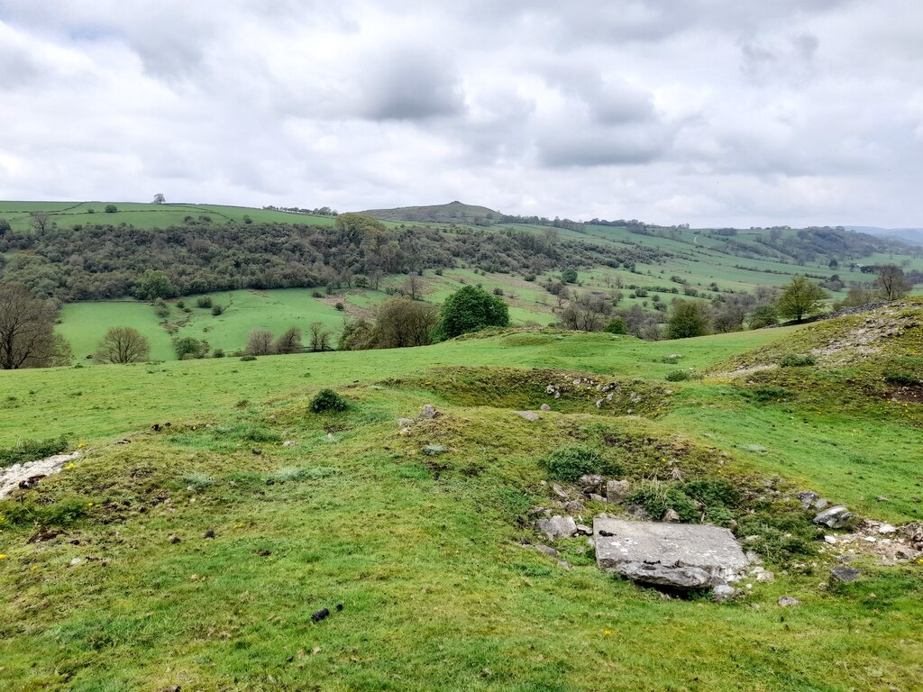
At Horse Step a sleepered shaft stands beside a gin circle with a ruined surrounding wall, partly overlain by the ruined walls of a large rectangular building, presumably a coe. A short water channel with a small platform leads to two ore-dressing ponds. Willfield Vein has several ruinous coes with internal shafts, a belland yard wall and a large pond of probable mining date.
Closure
Ore was last measured at Horse Step in 1805; smaller titles on the hill were measured until 1868.
What remains
A well-preserved line of vein hillocks runs along Horse Step, except at the centre where the hillocks to either side were removed for reprocessing at the mine complex. The surface remains of Horse Step are listed among the important lead mining sites of the Peak District.
Vein hillocks and hollows along all three veins; at Horse Step a gin circle, the ruins of a coe, a shaft and two dressing ponds; on Willfield Vein ruined coes, a belland yard wall and a pond.
Nearby mines
- Lathkill Dale Mine — 2.2 miles (3.6 km) NE
- Hillocks Mine — 2.9 miles (4.6 km) N
- Knotlow Mine — 3.0 miles (4.8 km) N
- Ecton Copper Mines — 3.5 miles (5.7 km) SW, Staffordshire
- Dowlow Works — 3.6 miles (5.9 km) NW
Straight-line distance, within 9 miles (15 km). Show on the map.
Further reading
The county record of the vein hillocks, gin circle, coe and dressing ponds at Carder Low.
View sourceThe society's gazetteer of the Hartington Liberty mines, with the Barmaster's freeings on the Carder Low, Willfield and Horse Step veins.
View sourceSources
- (secondary) Gazetteer of Hartington Liberty (Mining History 18.3) — Peak District Mines Historical Society
- (secondary) MDR13973 - Carder Low Mines, Hyde Lane, Hartington — Derbyshire Historic Environment Record
Record created: 14 November 2026 · Last researched: 14 November 2026