 MineArchive
Canonbie Colliery
| Also known as | Rowanburn Colliery, Blinkbonny Colliery, Rowanburnhead |
|---|---|
| Location | Rowanburn, Canonbie, Dumfries and Galloway — 55.0867, -2.9279 (exact) |
| Commodity | Coal |
| Type | Coal |
| Worked | 1854–1922 |
| Maximum depth | Unknown. The seams of the field dip southwards beneath newer rocks and reach a maximum depth of around 4,600 feet where they are faulted down into the Solway syncline, but that figure describes the coalfield, not this pit. |
| Operators | Duke of Buccleuch (1854–?), Canonbie Coal Co., Ltd. (?–1922) |
Overview
The principal pit of the Canonbie coalfield, a small and largely concealed field in Dumfriesshire close to the English border, worked from about 1854 by the Duke of Buccleuch and latterly by the Canonbie Coal Co. Ltd. It stood at Rowanburn, the village built to house its men, and worked bituminous coal for households, local manufacturing and the limekilns, potteries, distilleries and tweed mills of the district. Employment peaked at around 178 in 1900 and had fallen to 38 by 1920; the colliery closed in 1922, effectively ending deep mining in the field.
History
Coal was known at Canonbie long before there was a colliery of that name. Eighteenth-century documents refer to coal mines at Archerbeck, Skeltonscleugh, Byerburn, Knottyholm and Fairy Loup, three seams were being worked underground by about 1805, and collieries were at work at Archerbeck and Byreburn in the 1830s. The field itself is small and mostly concealed, roughly triangular, with no workings south of the Rowanburn Fault. It was surveyed comprehensively by Peach and Horne in a paper published by the Royal Society of Edinburgh in 1903.
The colliery at Rowanburn was sunk by the Duke of Buccleuch, whose family held the ground, and the Durham Mining Museum gives 1854 as its opening. Its coal was bituminous and sold as household and manufacturing coal rather than for export or coking, and it supplied the limekilns, pottery kilns, distilleries and tweed mill of the surrounding district. The National Record of the Historic Environment records the site under the names Rowanburn, Canonbie Colliery, Blinkbonny Colliery and Rowanburnhead, and classifies it as a nineteenth-century colliery with associated bell pits and mine workings, a reminder that the ground had been scratched at from the surface long before it was worked properly.
The government Lists of Mines chart a long, slow decline. In 1894 the colliery employed 135 people, 102 of them below ground. Numbers held at around 107 to 118 through 1900, 1905 and 1910, then fell sharply: 54 in 1915, and 38 in 1920 and again in 1923. Ownership passed from the Duke of Buccleuch to the Canonbie Coal Co. Ltd. The seams worked shifted over the years, recorded as Black Top, Nine Feet and Seven Feet in 1910, Black Top, Five Feet and Seven Feet in 1915, and Nine Feet and Three Feet in 1920.
The colliery closed in 1922, and deep mining in the Canonbie field effectively ended with it, though the separate mine at Archerbeck worked on until 1942. The field has not been forgotten by industry: work from the 1980s onward suggested workable reserves survive beneath a cover of New Red Sandstone, and in 2014 New Age Exploration proposed a new coking coal mine in the Canonbie area.
Geology
The Canonbie coalfield is a small, largely concealed field carrying six thick seams of bituminous coal within about 230 feet of strata, in the Pennine Middle Coal Measures. The seams named in the field include Knottyholm, Archerbeck, Six Foot, Nine Foot, Five Foot, Eight Foot and Seven Foot, with less important coals in the underlying Lower Coal Measures and in the overlying Upper Coal Measures and Warwickshire Group. Because the measures are largely hidden beneath later cover and dip south into the Solway syncline, the field's extent had to be worked out by survey and borehole rather than read off the surface, which is what made Peach and Horne's 1903 account so useful. No workings lie south of the Rowanburn Fault.
Geological setting: Anticlines and Synclines (historical documentary reference), Sedimentary Beds and Seams (well documented example)
Workings
The pit at Rowanburn was worked with the ordinary equipment of a small Scottish colliery: the fatal accident to Samuel Lindsay in January 1922 describes a self-acting brae of 1 in 4½ gradient with cut-rope haulage serving four benches, Lindsay working as the hanger-on at its foot. The Inspector found the organisation defective, with no method in use for holding the cut portion of the rope securely. The National Record of the Historic Environment also classifies bell pits at the site alongside the colliery, the earlier and cruder way the same coal had been reached.
Closure
The colliery closed in 1922 after a decade of falling employment, from 108 in 1910 to 38 by 1920. It was last worked in 1920 by one dating and closed in 1922 by another, and the Lists of Mines figures repeated for 1923 suggest a run-down rather than an abrupt stop. Deep mining in the field ended with it; only Archerbeck carried on, to 1942. The field's problem was never the coal itself but its scale: six workable seams in a small concealed basin, remote from the larger Scottish fields.
What remains
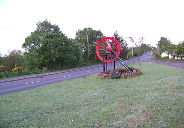
The pits are gone and the village remains. Rowanburn, built to house the coalfield's miners, keeps a winding wheel as a memorial to its mining years, and a separate memorial stands to Samuel Lindsay, killed in the pit in January 1922. The National Record of the Historic Environment holds mid-twentieth-century photographs of the spoil tips and of the mine looking north-east towards the village, along with geological maps and sections of the coalfield. Late nineteenth-century miners' rows of single-storey cottages, with their coal stores and wash-houses, are recorded at the village.
Spoil tips at Rowanburn are recorded photographically in the National Record of the Historic Environment, including one at NY 4052 7738, and the cutting of the former Langholm branch railway runs north-west near the village. The memorial to Samuel Lindsay survives in the village and is a separately recorded site. No account of surviving colliery buildings or shaft structures is recorded.
What's uncertain
Points where sources disagree or the record could not be settled; both accounts are kept. All open questions in the archive.
- Wikipedia's account of the coalfield states that Canonbie colliery was worked until 1920, while the separate mine at Archerbeck continued until 1942. (disputed) 2
Recorded claims
Individual factual claims, each attached to the source(s) that support it below. Where sources disagree, both are kept.
- The Durham Mining Museum records the colliery as opened in 1854 and closed in 1922, owned first by the Duke of Buccleuch and later by the Canonbie Coal Co. Ltd. 1
- Wikipedia's account of the coalfield states that Canonbie colliery was worked until 1920, while the separate mine at Archerbeck continued until 1942. (disputed) 2
- Government Lists of Mines record 135 employed in 1894 (102 below ground), 107 in 1900, 118 in 1905, 108 in 1910, 54 in 1915 and 38 in both 1920 and 1923. 1
- The seams worked are recorded as Black Top, Nine Feet and Seven Feet in 1910, Black Top, Five Feet and Seven Feet in 1915, and Nine Feet and Three Feet in 1920. 1
- The National Record of the Historic Environment records the site as Rowanburn, also known as Canonbie Colliery, Blinkbonny Colliery and Rowanburnhead, and classifies it as a nineteenth-century colliery with bell pits and mine workings. 3
- The Canonbie coalfield is small and largely concealed, with six thick seams of bituminous coal in about 230 feet of strata; the seams dip south beneath newer rocks and reach a maximum depth of around 4,600 feet in the Solway syncline. Peach and Horne published a comprehensive survey in 1903. 2
- The BGS mine-plans catalogue holds a Mining Remediation Authority abandonment plan titled 'Canonbie' (catalogue 7625, Nine Feet, dated 1922). 4
Photographs & further reading
Opening and closing dates, owners, the coal sold, employment figures and seams worked by List of Mines year from 1894 to 1923, and eight men recorded as killed at the colliery between 1840 and 1922 with the circumstances of each.
View sourceThe national monument record for the site, with its alternative names, its classification as colliery, bell pits and mine workings, an exact grid reference, and a set of mid-twentieth-century photographs of the spoil tips, the mine and the Langholm branch railway cutting, together with geological maps and sections of the coalfield.
View sourceBackground on the field as a whole: its concealed structure, the seams of the Pennine Middle Coal Measures, the eighteenth-century references to earlier pits, Peach and Horne's 1903 survey, and the 2014 proposal by New Age Exploration for a new coking coal mine in the area.
View sourceSources
- (primary) Canonbie Colliery — Durham Mining Museum
- (secondary) Canonbie Coalfield — Wikipedia
- (primary) Rowanburn (Canonbie Colliery), NRHE 92597 — National Record of the Historic Environment, Historic Environment Scotland
- (primary) BGS / Mining Remediation Authority mine plans: CANONBIE — British Geological Survey / Mining Remediation Authority
Record created: 10 September 2026 · Last researched: 10 September 2026