 MineArchive
Burnopfield Colliery
| Also known as | Hobson Pit, Hobson Colliery |
|---|---|
| Location | Hobson, south of Burnopfield, County Durham — 54.9003, -1.7303 (approximate) |
| Commodity | Coal |
| Type | Coal |
| Worked | 1742–1968 |
| Maximum depth | The Busty Bank seam at 90 fathoms (1894). |
| Operators | John Bowes & Partners Ltd (?–1947), Marley Hill Coal Company, National Coal Board (1947–1968) |
Overview
The Hobson Pit south of Burnopfield, sunk in the eighteenth century and worked by John Bowes and Partners, whose boilers were blown up by striking Marley Hill miners in 1850; it gave its name to the village of Hobson, fed coke ovens and firebrick works, and closed in 1968.
History
Burnopfield Colliery, better known locally as the Hobson Pit, was first sunk in about 1725 by one account or 1742 by another, and the pit village of Hobson grew up around it just south of Burnopfield. In the 1850s it belonged to John Bowes and Company, the partnership of John Bowes, Hutt, Wood and Charles Mark Palmer. During a bitter strike at Bowes's Marley Hill colliery over low wages in the winter of 1849-50, Hobson supplied small coal to the Marley Hill coke ovens, and in January 1850 striking Marley Hill miners blew up the boilers at the Hobson Pit with gunpowder. The Marley Hill Coal Company held it in the 1860s and John Bowes and Partners from the 1880s. In 1894 the pit worked the Main Coal, about three feet thick at 50 fathoms, and the Busty Bank seam, seven feet thick at 90 fathoms with a band of fireclay in its centre; it raised about 140,000 tons a year, and with its coke ovens and firebrick works employed 300 men and boys. Employment grew to 669 in 1940, working the Brass Thill, Busty, Hutton, Main and Brockwell seams for coking and gas coal. Nationalised in 1947, it employed over 500 until the 1960s and closed on 9 August 1968.
Geology
Durham Coal Measures: the Main Coal (3 ft to 3 ft 6 in at 50 fathoms) and the Busty Bank (7 ft at 90 fathoms, with 9 to 12 feet of fireclay in its centre), later the Brass Thill, Hutton, Brockwell, Five Quarter, Shield Row, Three Quarter and Tilley.
Workings
The Hobson Pit shaft, with coke ovens and a firebrick works alongside.
Closure
Closed on 9 August 1968.
What remains
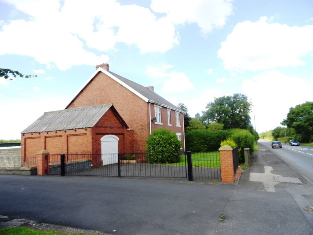
Virtually everything has gone; a brick house by the road may have been the colliery manager's house, and the Hobson golf course lies nearby.
Possibly the colliery manager's house.
Redevelopment
Unknown.
Related mines
- Marley Hill Colliery — Both John Bowes collieries: Hobson supplied Marley Hill's coke ovens during the 1849-50 strike, and Marley Hill's 1908 by-product plant replaced Burnopfield's ovens.
Nearby mines
- Lintz Colliery — 1.5 km W
- Byermoor Colliery — 1.8 km NE, Tyne and Wear
- West Stanley Colliery — 3.5 km SE
- Marley Hill Colliery — 3.6 km E, Tyne and Wear
- Louisa Colliery — 4.1 km SE
Straight-line distance, within 15 km. Show on the map.
What's uncertain
Points where sources disagree or the record could not be settled; both accounts are kept. All open questions in the archive.
- Burnopfield Colliery was first sunk in about 1725; another source gives 1742. (disputed) 2
Recorded claims
Individual factual claims, each attached to the source(s) that support it below. Where sources disagree, both are kept.
- Burnopfield Colliery, also known as Hobson Pit, opened 1742 and closed 9 August 1968; owners John Bowes & Co. (1850s), Marley Hill Coal Co. (1860s), John Bowes & Partners (1880s-1947), then the NCB; peak employment 669 in 1940. 1
- In 1894 the Hobson pit met the Main Coal (3 ft to 3 ft 6 in, 50 fathoms) and the Busty Bank (7 ft, 90 fathoms, with fireclay); about 140,000 tons a year, and with the coke ovens and firebrick works employing 300 men and boys (Whellan's Directory). 1,2
- Burnopfield Colliery was first sunk in about 1725; another source gives 1742. (disputed) 2
- In 1850 the boilers at Hobson Pit were blown up with gunpowder by striking miners from Marley Hill; Hobson had been supplying Marley Hill coke ovens with small coal during the strike. 2
Photographs & further reading
Owners, employment, seams and the 1894 directory description of the Hobson Pit.
View sourceSources
- (secondary) Durham Mining Museum - Burnopfield Colliery — Durham Mining Museum
- (secondary) Burnopfield Colliery (1725 - 1968) — Co-Curate, Newcastle University
Record created: 21 September 2026 · Last researched: 21 September 2026