 MineArchive
Brennand Mine
| Also known as | Whitewell Mine, Brennand Level |
|---|---|
| Location | Middle Knoll, Brennand valley, Forest of Bowland, Lancashire — 53.9835, -2.5411 (approximate) |
| Commodities | Lead, Zinc |
| Type | Metal |
| Worked | 1814 (lease)–1874 |
| Maximum depth | 34 fathoms (62 m), Fifth Level |
| Operators | Whitewell Mining Company Limited (1866–1874) |
Overview
A lead mine on Middle Knoll in the Brennand valley, Forest of Bowland, first leased in 1814 and revived when drain-diggers found ore in 1865; the Whitewell Mining Company raised about 2,000 tons of ore before giving it up in 1874.
History
Brennand Mine worked the Brennand Vein on Middle Knoll, at the head of the Brennand valley in the Forest of Bowland. In 1814 a partnership leased the vein from the Duchess of Buccleuch: a grant 180 yards wide running north-east from the Brennand River for about 1,000 yards to the wall between Brennand and Whitendale farms. The partners were to smelt their ore at a mill being built on Newton Fell and give the Duchess one-eighth of the lead, and the Hush Level workings probably date from then.
The mine then seems to have lain idle until 1865, when men cutting drains found lumps of lead ore. The Whitewell Mining Company was floated in January 1866 and leased the mine from Colonel Towneley of Burnley. A trial pit in Far Pasture Clough found the vein four feet wide; the Brennand Level was driven from near the beck at Brennand House to cut it at the Fifth Level, 34 fathoms down at the Engine Shaft, with four levels above at about 7, 16 and 25 fathoms and at the surface. The vein followed the axis of the Sykes anticline, and the ore lay in the Red Beds Limestone, ending where the massive shales stopped the mineralisation; zinc blende was present but not worked. Output fell from 1871, a time of low lead prices, and the company gave the mine up in August 1874, having raised about 2,000 tons of ore, dressed at the mouth of the Brennand Level. A survey of 1983 found the greatest concentrations of lead and zinc in the area from the Brennand Level adit north-east to Whitendale, the part most intensively mined.
Geology
A lead and zinc vein along the axis of the Sykes anticline (Brennand pericline), with ore in the Red Beds Limestone of the Dinantian, cut off by overlying shales.
Workings
The Brennand Level from near Brennand House to the Fifth Level at 34 fathoms, an Engine Shaft with levels at about 7, 16 and 25 fathoms, and the earlier Hush Level workings; ore dressed at the level mouth.
Closure
Given up by the Whitewell Mining Company in August 1874 after output fell during low lead prices.
What remains
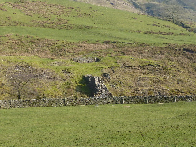
Ruined stone mine buildings stand on the hillside near Brennand Farm.
Ruined stone buildings and walls of the mine near Brennand Farm.
Redevelopment
Unknown.
Related mines
- Sykes Mine — Bowland lead workings on the Sykes and Brennand anticlines, about 3 km apart.
Nearby mines
- Sykes Mine — 1.9 miles (3.0 km) SW
- Ashnott Lead Mine — 4.8 miles (7.7 km) SE
Straight-line distance, within 9 miles (15 km). Show on the map.
Recorded claims
Individual factual claims, each attached to the source(s) that support it below. Where sources disagree, both are kept.
- In 1814 a partnership leased the Brennand Vein on Middle Knoll from the Duchess of Buccleuch, who was to receive one-eighth of the smelted lead. 1
- Ore was found by men cutting drains in 1865, and the Whitewell Mining Company was floated in January 1866, leasing from Colonel Towneley. 1
- The Brennand Level cut the vein at the Fifth Level near the Engine Shaft, 34 fathoms deep. 1
- Output fell from 1871 and the company gave up the mine in August 1874, having produced about 2,000 tons of ore. 1
- The greatest lead and zinc concentrations occur in the most intensively mined area, from the Brennand Level adit north-east to Whitendale; extraction was most intensive in 1866-71. 2
- Plans of the Brennand Mine (Whitewell) are held by the British Geological Survey. 3
- Ruins of an old lead mine building stand near Brennand Farm. 4
Sources
- (secondary) Brennand Mine — Northern Mine Research Society
- (primary) Geology of the Trough of Bowland area (SD 65 SW), BGS Technical Report WA/87/46 — British Geological Survey
- (primary) BGS mine plan: Brennand Mine (Whitewell) — British Geological Survey
- (observational) Old lead mine building near Brennand Farm — Geograph
Record created: 17 October 2026 · Last researched: 17 October 2026