 MineArchive
Blaen Baglan Colliery
| Also known as | Baglan Colliery, Blaenbaglan Colliery, Cwm Baglan Colliery |
|---|---|
| Location | Blaen Baglan, above Baglan, between Briton Ferry and Port Talbot, Neath Port Talbot — 51.6146, -3.7858 (exact) |
| Commodity | Coal |
| Type | Coal |
| Worked | By 1842–1879 |
| Maximum depth | 89 yards (shaft sunk 1862) |
| Operators | Thomas and Williams (1854–1870), Pascoe Grenfell and Sons (1875–1882), Edward Thomas and Company |
Overview
A small colliery of levels and shafts on the hillside at Blaen Baglan above Baglan, in existence by 1842 and listed from 1854 to 1870 under Thomas and Williams, abandoned in 1879, and recorded at the same spot as a Baglan Colliery sunk in 1862, owned by Pascoe Grenfell and Sons in the later 1870s and last listed with seven men in 1923.
History
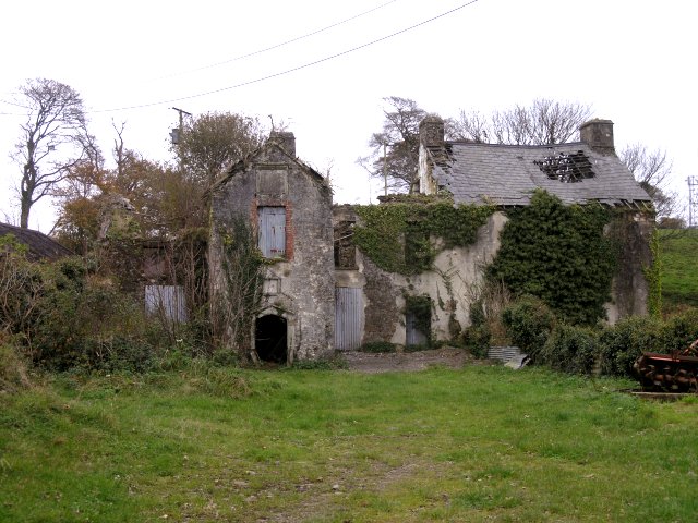
Blaen Baglan Colliery took its name from the old farmhouse of Blaen Baglan, rebuilt about 1600, on the hill between Baglan and Cwmafan. Its levels and shafts lay a little east of the house. The working was in existence by 1842 and appears in the lists of mines from 1854 to 1870 as Baglan or Blaen Baglan, owned by Thomas and Williams; the Thomas may have been the Edward Thomas who opened the Swan and Park collieries down the hill at Baglan in the late 1850s. It was abandoned in 1879, and it may be the working elsewhere called Cwm Baglan.
The records of the several Baglan pits are tangled. At the same grid reference the Northern Mine Research Society lists a Baglan Colliery sunk in 1862 to 89 yards by the Baglan Swan Colliery Company, owned by Grenfell and Sons from 1875 to 1882 under the manager J. Walter, working the Waunffynnonau seam in 1915 and employing five men underground and two on the surface in 1923, after which no men were listed. Whether this is the same working as the 1854 to 1870 Baglan of Thomas and Williams, reopened after 1879, or a neighbouring pit on the same hillside, the sources do not settle.
The abandonment plan held by the Mining Remediation Authority shows the Blaenbaglan old levels and an air shaft at two chains to the inch, with outcrops of the Finery, Sulphury and Upper Four Feet seams and a reference to the Six Feet vein.
Geology
Coal Measures seams outcropping on the hillside above Baglan: the abandonment plan shows the Finery, Sulphury and Upper Four Feet seams and refers to the Six Feet vein, and the Waunffynnonau seam was worked in 1915.
Geological setting: Sedimentary Beds and Seams (historical documentary reference)
Workings
Old levels driven into the outcrops on the hillside with an air shaft, shown on the abandonment plan at two chains to the inch; a shaft sunk in 1862 to 89 yards is recorded at the same spot.
Closure
Abandoned in 1879. A Baglan Colliery recorded at the same grid reference employed seven men in 1923 and was not listed afterwards.
What remains
Unknown.
Redevelopment
None.
Related mines
- Baglan Hall Colliery — The Park and Swan collieries down the hill shared Edward Thomas and Pascoe Grenfell and Sons with the Baglan workings here, and the records of the two sites are tangled together.
Nearby mines
- Cwmmawr Colliery — 0.8 miles (1.2 km) NE
- Baglan Hall Colliery — 1.3 miles (2.0 km) W
- Cwmavon Copper Works — 1.4 miles (2.2 km) NE
- Swan Colliery — 1.5 miles (2.5 km) NW
- Wern Colliery, Cwmafan — 1.6 miles (2.6 km) N
Straight-line distance, within 9 miles (15 km). Show on the map.
What's uncertain
Points where sources disagree or the record could not be settled; both accounts are kept. All open questions in the archive.
- A Baglan Colliery at the same grid reference was sunk in 1862 to a depth of 89 yards by the Baglan Swan Colliery Company. (uncertain) 2
- Grenfell and Sons owned the Baglan Colliery from 1875 to 1882, when J. Walter was manager. (uncertain) 2
- In 1915 the colliery was working the Waunffynnonau seam, and in 1923 it employed five men underground and two on the surface, after which no men were listed. (uncertain) 2
- The site may be the same as the working recorded as Cwm Baglan. (uncertain) 1
Recorded claims
Individual factual claims, each attached to the source(s) that support it below. Where sources disagree, both are kept.
- The colliery was in existence by 1842 and was listed from 1854 to 1870 as Baglan or Blaen Baglan. 1,2
- From 1854 to 1870 the owner was Thomas and Williams. 1,2
- Blaen Baglan was abandoned in 1879. 1
- The Blaen Baglan level is at SS764921; the site is also given as SS762921. 1
- A Baglan Colliery at the same grid reference was sunk in 1862 to a depth of 89 yards by the Baglan Swan Colliery Company. (uncertain) 2
- Grenfell and Sons owned the Baglan Colliery from 1875 to 1882, when J. Walter was manager. (uncertain) 2
- In 1915 the colliery was working the Waunffynnonau seam, and in 1923 it employed five men underground and two on the surface, after which no men were listed. (uncertain) 2
- The abandonment plan of the Blaenbaglan old levels and air shaft, at two chains to the inch, shows outcrops of the Finery, Sulphury and Upper Four Feet seams and refers to the Six Feet vein. 3
- The site may be the same as the working recorded as Cwm Baglan. (uncertain) 1
- Blaen Baglan is a substantial farmhouse rebuilt about 1600 by William Williams, derelict by 2000. 4
Photographs & further reading
The page on the Baglan collieries, with the Blaen Baglan grid reference, dates and owner and the site's caution about the tangled records.
View sourceThe Northern Mine Research Society's entries for the Baglan collieries, including the Baglan Colliery at this grid reference.
View sourceThe Royal Commission's record of the farmhouse the colliery was named from.
View sourceSources
- (secondary) Baglan Hall Collieries — Welsh Coal Mines
- (secondary) NMRS: Baglan Park and Swan Collieries — Northern Mine Research Society
- (primary) BGS mine plan: Blaenbaglan, old levels, airshaft (abandonment plan) — British Geological Survey
- (primary) Blaen Baglan (house), NPRN 18038 — Coflein
- (observational) Blaen Baglan Farm (photograph, 2011) — Geograph
Record created: 17 October 2026 · Last researched: 21 October 2026