 MineArchive
Alnwick Moor Bell Pits
| Location | Alnwick Moor, Northumberland — 55.3829, -1.7936 (approximate) |
|---|---|
| Commodity | Coal |
| Type | Coal |
| Worked | 16th century–Mid-18th century |
| Maximum depth | Unknown. Shallow bell-pit and shaft working to seams lying tens of feet down. |
| Operators | Burgesses of Alnwick (1500–1750) |
Overview
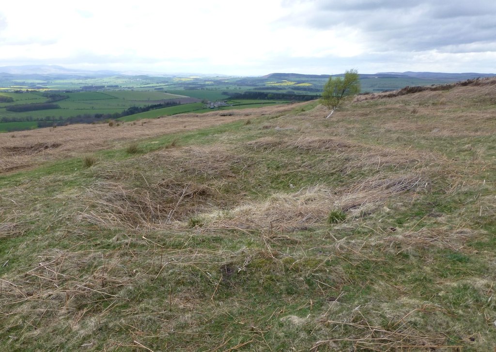
At least a hundred pits and shafts of the 16th and 17th centuries spread across some 35 hectares of Alnwick Moor, dug for the Scremerston coals. From the 16th century to the middle of the 18th, when the minerals belonged to the burgesses of Alnwick, the town was chiefly supplied with coal from this moor.
History
The common moor west of Alnwick belonged to the burgesses of the town, and with it the coal beneath. George Tate, the town's 19th-century historian, records that from the 16th century to the middle of the 18th, while the minerals were the burgesses', Alnwick was chiefly supplied with coal from the moor; other collieries worked nearer the town in the Town Fields and the Stocken, and in the Abbey grounds, where in 1775 a piece of meadow a hundred yards long and fourteen broad sank above fourteen feet beside some coal pits. Three at least of the seams were worked on the moor. The uppermost, a slaty coal thirty inches thick lying thirty-six feet below the Dun limestone, had a band of stone through the middle of it and was poor stuff and expensive to work; a second seam forty-seven feet lower was two feet thick and better, half of it fit for house coal; and a deeper seam was worked near the Brick Kilns and the West Gate. The pits that survive are dated by the scheduling to the 16th and 17th centuries. Below the coal that was worked lie the better seams of the Scremerston group, which Tate expected at about 300 feet for the Scremerston Main, the Cancer coal a hundred feet below that, then the Cooper Eye, the best of all, and last the Wester coal.
Geology
The pits worked the Scremerston coals of the Carboniferous rocks of north Northumberland, the group that carries the workable seams of this part of the county. The seams reached from the moor were thin — thirty inches and twenty-four inches — and lay below the Dun limestone; the thicker Scremerston Main and the seams under it were far deeper and out of reach of this kind of working.
Workings
The remains cover about 35 hectares and include at least a hundred pits and shafts of varying size. Some are ringed by collars of spoil that form shaft mounds; between them are the remains of gin circles, the level tracks where a horse walked round to drive the winding or pumping gear, and of buildings, all surviving as low earthworks.
Closure
Tate dates the moor's supply of coal to the town as running from the 16th century to the middle of the 18th, after which it passed; the scheduling puts the surviving pits in the 16th and 17th centuries. No date for the last pit on the moor is recorded.
What remains
The pits, shafts, shaft mounds, gin circles and building earthworks are a scheduled monument on open moorland west of the town. The scheduling record is an old county number entry, one of the oldest kinds of designation record, enhanced in June 2016.
At least a hundred pits and shafts of varying sizes, some with spoil collars forming shaft mounds, with gin circles and building remains between them as low earthworks.
Redevelopment
None. The ground is open moorland and rough grazing.
Nearby mines
- Whittle Colliery — 5.7 km SE
- Framlington Colliery — 7.4 km S
- Shilbottle Colliery — 8.6 km E
- Longhoughton Quarry — 11.2 km NE
Straight-line distance, within 15 km. Show on the map.
Recorded claims
Individual factual claims, each attached to the source(s) that support it below. Where sources disagree, both are kept.
- The monument includes the remains of at least 100 pits and shafts of 16th to 17th century date spread over about 35 hectares of Alnwick Moor, with shaft mounds, gin circles and building remains surviving as low earthworks. 1
- The shafts were sunk for coal of the Scremerston coal measures. 1
- From the 16th century to the middle of the 18th, while the minerals belonged to the burgesses, the town of Alnwick was chiefly supplied with coal from Alnwick Moor. 2
- Three seams at least were worked on the moor: a slaty coal thirty inches thick thirty-six feet below the Dun limestone, a better seam of twenty-four inches forty-seven feet lower, and a deeper seam worked near the Brick Kilns and West Gate. 2
Photographs & further reading
The society's page on the parish's coal and stone, quoting George Tate's account of the seams worked on Alnwick Moor and the town's supply of coal from the burgesses' ground.
View sourceSources
- (primary) Bell pits and shafts on Alnwick Moor (List entry 1006419) — Historic England
- (secondary) Mining & Quarrying — Alnwick & District Local History Society
Record created: 22 September 2026 · Last researched: 22 September 2026