 MineArchive
Westfield Opencast
| Also known as | Westfield Opencast Mine, Westfield Opencast Coal Site |
|---|---|
| Location | Westfield, near Kinglassie, west Fife — 56.1689, -3.2917 (approximate) |
| Commodity | Coal |
| Type | Coal |
| Worked | 1955–1998 (final extraction from 2008) |
| Maximum depth | About 200 metres (1977) |
| Operators | National Coal Board (1955–?), Scottish Coal (?–2013), Costain Mining Ltd |
Overview
An opencast coal site near Kinglassie in west Fife, begun in 1955 on the ground of the old Kirkness Colliery and worked until 1998, with a last extraction from 2008. The largest and longest-lived opencast coal mine in British history, it fed a Lurgi gasification plant and left one of Europe's largest pit lakes.
History
Westfield lies on the outskirts of Kinglassie, in the north-west of the Fife coalfield. Excavation began in 1955 on the site of the former Kirkness Colliery, and production started the following year. The Westfield Basin held some 23 thick but lenticular coals in the Lower Coal Measures and the Passage Formation, more than 35 million tonnes in all, folded into a steep syncline against the East Ochil Fault, with an overburden-to-coal ratio in low single figures: by far the most remarkable coal deposit in Britain, and the mainstay of the largest and longest-lived opencast coal mine in British history. Costain Mining Ltd worked it for the National Coal Board's Opencast Executive.
The main pit was worked in phases: Phase I from January 1961 to September 1968, recovering 5.4 million tonnes of coal, Phase II from October 1968 to October 1973, and Phase III from October 1973 to 1984, with an extension alongside; the Link Site took shallow coal from 1991 to 1996. During Phase III the East Ochil Fault was deliberately breached to stabilise the slopes, letting in a lasting flow of groundwater. By 1977 the excavation was about 200 metres deep, cutting from the top of the Middle Coal Measures down to the Calmy Limestone. In 1960 the National Coal Board opened a Lurgi high-pressure gasification plant beside it to make gas from Westfield's low-rank coal, the base load of central Scotland's gas supply. Coal went out by rail, slurry eastward to Methil power station; the line west to Kelty closed in 1966. Coaling and backfilling ended in 1998, leaving residual voids that filled as one of Europe's largest pit lakes, and the largest in bituminous coal. The site was opened again in 2008 for a final extraction. After the collapse of Scottish Coal, Hargreaves Land took it over in 2013 for redevelopment.
Geology
The Westfield Basin: some 23 lenticular coals, six in the Lower Coal Measures and seventeen in the Passage Formation, including the abnormally thick Boglochty Beds, in a steep synclinorium plunging north-east against the East Ochil Fault; more than 240 metres of strata were mined.
Workings
Opencast Phases I to III (1961-84), the Extension and the Link Site (1991-96); a washery and processing plant; rail sidings and a loading point on the Kelty-Redford line; the Lurgi gas plant alongside.
Closure
Coaling and backfilling ended in 1998; the site reopened in 2008 for a last extraction.
What remains
The Main Void and the East Void hold a large pit lake; the ground is one of Scotland's largest brownfield sites, over 1,000 acres.
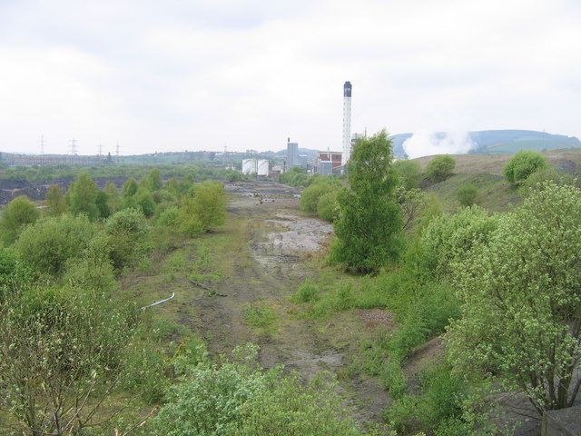
The Lurgi plant's tall chimney and buildings stood beside the site in 2007.
Redevelopment
Hargreaves Land acquired the site in 2013; an energy-from-waste plant was under construction there, with battery storage earmarked next, the first phase of a hub for employment, recycling and green energy.
Nearby mines
- Capledrae Colliery — 0.8 miles (1.2 km) SW
- Bowhill Colliery — 1.7 miles (2.7 km) SE
- Glencraig Colliery — 1.9 miles (3.1 km) SW
- Mary Colliery, Lochore — 2.0 miles (3.3 km) SW
- Minto Pit — 2.1 miles (3.4 km) S
Straight-line distance, within 9 miles (15 km). Show on the map.
Recorded claims
Individual factual claims, each attached to the source(s) that support it below. Where sources disagree, both are kept.
- Excavation began in 1955 on the site of the former Kirkness Colliery, and production started in 1956. 1,2
- The Westfield Basin held some 23 coals with a total reserve of more than 35 million tonnes. 3
- Phase I was worked from January 1961 to September 1968 and recovered 5.4 million tonnes of coal. 3
- The pit was worked by Costain Mining Limited for the National Coal Board Opencast Executive. 2
- The National Coal Board opened a Lurgi high-pressure gasification plant in 1960 to use Westfield's low-rank coal. 1
- Coaling and backfilling ended in 1998; the site reopened in 2008 for a final extraction. 1,3
- Hargreaves Land secured the site in 2013 after the collapse of Scottish Coal. 4
Photographs & further reading
The basin's geology, the phases of working and the pit lake.
View sourceAn aerial photograph of the pit in 1977 with its geology.
View sourceSources
- (secondary) Westfield Opencast — Railscot
- (secondary) Westfield Opencast Coal Mine, 1977 — BGS Geoheritage
- (secondary) Westfield pit lake, Fife (Scotland): the evolution and current hydrogeological dynamics of Europe's largest bituminous coal pit lake (P. L. Younger, 2005) — International Mine Water Association
- (secondary) Westfield — I & H Brown
Record created: 4 October 2026 · Last researched: 4 October 2026