 MineArchive
Wardley Colliery
| Location | Wardley, Gateshead, Tyne and Wear — 54.9517, -1.5233 (approximate) |
|---|---|
| Commodity | Coal |
| Type | Coal |
| Worked | 1855–8 August 1974 |
| Maximum depth | About 1,259 feet |
| Operators | John Bowes & Partners Ltd (1855–?), Washington Coal Company Ltd (?–1946), National Coal Board (1947–1974) |
Overview
A John Bowes & Partners colliery at White Mare Pool, opened in 1855 with a shaft section to 1,259 feet, closed in 1911 and reopened in 1959 when it merged with Follonsby; it finally closed on 8 August 1974.
History
Wardley Colliery stood at White Mare Pool in the township of Heworth, about three and a half miles east-south-east of Newcastle, where George Rawlings was boring in 1800. John Bowes & Partners opened it in 1855, though coal-getting was not fairly under way until 1871. In 1894 it employed 800 men and boys and raised about 1,000 tons a day from the Maudlin seam, 5 feet 6 inches thick at 181 fathoms, and the Hutton seam, 3 feet, 23 fathoms deeper. About 300 yards south of the shaft a 'roll' threw the Hutton up to 4 fathoms above the Maudlin level and the Maudlin itself up by 27 fathoms, over some 150 yards. The miners' village had a Primitive Methodist chapel of 1884, a board school of 1878 and a Miners' Hall and Institute of 1889, built for £960, with a hall for nearly 600, a reading room and library. Follonsby Colliery replaced Wardley when it closed in 1911. In 1959 Wardley was reopened and merged with Follonsby, whose shaft became Wardley No. 1, the original shafts becoming Nos. 2 and 3; in 1969 Wardley was used for drawing coal and Usworth for riding men. The colliery, owned by the Washington Coal Company in the 1940s and the National Coal Board from 1947, closed on 8 August 1974.
Geology
The shaft section runs to 1,258 feet 8 inches and passes the Maudlin seam at about 1,089 feet, the Five-Quarter at 1,165 feet and the Hutton, 3 feet 8 inches thick, at about 1,227 feet. A 'roll' about 300 yards south of the shaft threw the seams upwards for some 150 yards.
Workings
Wardley worked the Maudlin and Hutton seams in the 1890s. After the 1959 merger its coal was wound through Follonsby's shaft, Wardley No. 1, which was linked with Usworth by an underground locomotive road.
Closure
The colliery closed on 8 August 1974. It employed 695 in 1967-68, down from 843 in 1964-65.
What remains
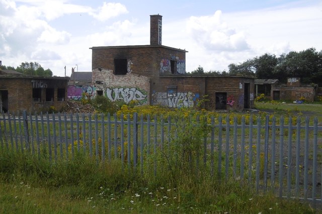
A building on the colliery site appears to have had industrial use after closure, and the old colliery road still crosses the railway to Sunderland.
Redevelopment
A building on the site appears to have had post-colliery industrial use.
Related mines
- Follonsby Colliery — Follonsby was sunk to replace Wardley in 1911 and became Wardley No. 1 pit when the two merged in 1959; Bowes, then the Washington Coal Company, then the NCB owned both.
- Usworth Colliery — After the 1959 merger with Follonsby the two shared a Washington Coal Company/NCB unit; in 1969 Wardley was used for drawing coal and Usworth for riding men.
Nearby mines
- Follonsby Colliery — 0.0 miles (0.1 km) E
- Felling Colliery — 1.9 miles (3.0 km) W
- Walker Colliery — 1.8 miles (3.0 km) NW
- Springwell Colliery — 2.3 miles (3.7 km) SW
- Usworth Colliery — 2.4 miles (3.8 km) S
Straight-line distance, within 9 miles (15 km). Show on the map.
Recorded claims
Individual factual claims, each attached to the source(s) that support it below. Where sources disagree, both are kept.
- John Bowes & Partners opened Wardley Colliery in 1855. 1,2,3
- In 1894 the colliery raised about 1,000 tons a day and employed 800 men and boys. 1,2
- The Maudlin seam, 5 feet 6 inches thick, was worked at 181 fathoms, and the Hutton seam, 3 feet thick, lay 23 fathoms deeper. 1,4
- A 'roll' about 300 yards south of the shaft threw the Hutton seam up 4 fathoms above the Maudlin level and the Maudlin up 27 fathoms, over about 150 yards. 1
- The Miners' Hall and Institute of 1889 cost £960 and had a hall for nearly 600. 1,2
- The colliery closed in 1911 and was replaced by Follonsby Colliery. 1
- In 1959 Wardley reopened and merged with Follonsby Colliery, whose shaft became Wardley No. 1. 1,2
- The colliery closed on 8 August 1974. 1,2,3
- The Coal Authority holds abandonment plans for the Maudlin and Low Main seams at Wardley. 5
Photographs & further reading
Photograph of a building on the colliery site with later industrial use.
View sourceOwners, output, employment 1894-1968, the 1911 and 1959 changes, Whellan's 1894 description and a list of those killed.
View sourceThe county Historic Environment Record entry with the colliery's dates, owners and village buildings.
View sourceShort account of the colliery and its village, with linked resources.
View sourceSources
- (primary) Durham Mining Museum - Wardley Colliery — Durham Mining Museum
- (primary) Wardley Colliery (HER 3813) — Tyne and Wear Historic Environment Record (Sitelines)
- (secondary) Wardley Colliery (1855-1974) - Co-Curate — Co-Curate (Newcastle University)
- (primary) Durham Mining Museum - Wardley Colliery Shaft Details — Durham Mining Museum
- (primary) BGS / Mining Remediation Authority abandonment plans: WARDLEY — British Geological Survey
Record created: 29 September 2026 · Last researched: 29 September 2026