 MineArchive
Walterclough Colliery
| Location | Southowram, Halifax, West Yorkshire — 53.7139, -1.8113 (approximate) |
|---|---|
| Commodities | Coal, Fireclay |
| Type | Coal |
| Worked | 1888 (as generally stated)–18 February 1969 |
| Maximum depth | 90 yards (main shaft to the Soft Bed); the workings are said to have extended about 100 yards down. |
| Operators | Messrs Brookes Ltd (1906–1969) |
Overview
A coal and fireclay pit in the Walterclough Valley east of Halifax, generally said to have opened in 1888 and the largest and last pit in the Southowram district. Brooke's Limited of Hipperholme bought it in 1906 to feed its brickworks, rebuilt it before and during the First World War with an aerial ropeway up to Hove Edge, and closed it on 18 February 1969 when the firm itself closed. Its winding house, fan house and offices were recorded in 2012 before conversion.
History
Walterclough Pit stood on the Red Beck in the Walterclough Valley, south-east of Halifax and north-east of Southowram, one of a belt of collieries east of the town between Elland and Queensbury; the nearest was Sunny Bank, a short distance to the north-west. The site had earlier been Walter Clough Mill, a water-powered woollen mill shown in 1854 and derelict by the 1890s, whose remains were buried under the pit's spoil by 1922. The Northern Mine Research Society lists a Walter Clough pit at Shibden sinking from 1873 to 1878, but the colliery is generally said to have opened in 1888, its workings extending about 100 yards down to the local coal and fireclay seams; who sank the shafts is not on record. The 1893 Ordnance Survey map shows two shafts, unnamed, beside a spoil mound, and a late nineteenth-century photograph shows a single wooden headgear, an open cage for two men, and an early aerial ropeway to a landing called Pier Head, where carts collected the coal.
In 1906 the pit was bought to supply coal and fireclay to a brickworks near the Nonslip Stone Company's works at Hipperholme, the quarrying concern founded by Joseph Brooke in 1840 that had become Brooke's Limited in 1900. The map of 1907 names it 'Walterclough Pit (Coal)' for the first time; by 1922 it was 'Walterclough Pit (Coal and Clay)', with a much enlarged engine and boiler house, a new winding house for the western shaft, a third shaft, and an aerial ropeway running north-east over Wood Bottom Lane, now Sutcliffe Wood Lane, to a terminus beside Tuck Royds Quarry at Hove Edge, whence a mineral railway ran into the Brooke's works. The pit worked the Halifax Hard Bed, the Middle Band, the Thirty-Six Yards Band, the Silica Rock and the Soft Bed, with fireclay and ganister beneath the coal; the main shaft was 90 yards to the Soft Bed. In 1912 the collier Walter Sharpe was killed by a stone from the roof while getting coal lying on his side in a seam only fifteen inches thick. Employment was 103 in 1923 and 65 in 1954, when the output was steam coal and fireclay.
The colliery is said to have produced coal until 1930 and fireclay thereafter, though the maps of 1933 and 1938 still call it a coal and clay pit, and the Hard Bed, Soft Bed and Thirty-Six Yards Band were still being worked in 1954. The colliery lists give its working life as 1905 to 1980. It remained in private ownership until 18 February 1969, when Brooke's Limited itself closed; the shafts were filled and capped, most of the buildings were demolished, and the Gibson family bought the land in 1971. The surviving winding house, fan house and mine offices with their showers were recorded in 2012, as a condition of planning permission for their conversion to housing.
Geology
The Halifax Hard Bed, Middle Band, Thirty-Six Yards Band, Silica Rock and Soft Bed of the Lower Coal Measures, with ganister and fireclay beneath the Hard Bed; the Westphalian fireclays were refractory clay for the iron and steel industry and the ganister went into silica bricks and road repairs.
Workings
Two square shafts side by side on a revetted platform, later a third circular shaft on the tip, with the winding house for the western shaft, an engine and boiler house for the eastern, a fan house with a fan drift, and an aerial ropeway up the north slope of the valley to Hove Edge.
Closure
Closed on 18 February 1969 with Brooke's Limited; the shafts were filled and capped and the land sold in 1971.
What remains
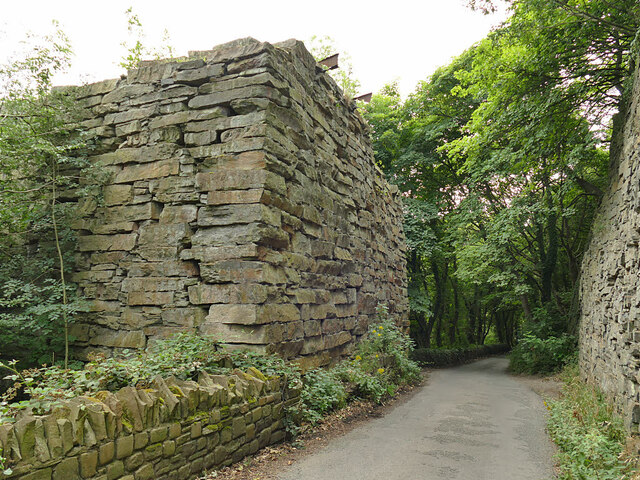
The winding house, fan house and mine offices survive, in use as farm buildings by 2011 and recorded in 2012 ahead of conversion to housing; a stone pier of the aerial ropeway stands on Sutcliffe Wood Lane.
The winding house with its guide pulley and cable openings, the fan house and fan drift, the two-storey mine offices with showers, the mill pond of the earlier woollen mill, and the ropeway pier.
Redevelopment
The surviving pit buildings were recorded in 2012 for conversion to residential use.
Nearby mines
- Booth Town Pit — 2.9 miles (4.7 km) NW
- Toftshaw Moor Colliery — 4.8 miles (7.7 km) NE
- Gomersal Colliery — 5.7 miles (9.2 km) E
- Heaton Colliery — 7.5 miles (12.1 km) N
- Northcliffe Colliery — 7.8 miles (12.5 km) N
Straight-line distance, within 9 miles (15 km). Show on the map.
What's uncertain
Points where sources disagree or the record could not be settled; both accounts are kept. All open questions in the archive.
- A Walter Clough pit at Shibden, Halifax, was sinking from 1873 to 1878. (uncertain) 4
Recorded claims
Individual factual claims, each attached to the source(s) that support it below. Where sources disagree, both are kept.
- The pit is generally said to have opened in 1888, the largest and last coal pit in the area, its workings extending about 100 yards down. 1,2,3
- The pit produced coal until 1930. 1,2
- A Walter Clough pit at Shibden, Halifax, was sinking from 1873 to 1878. (uncertain) 4
- The colliery lists give Walterclough's working life as 1905 to 1980, under Brookes Ltd. 5,4
- The 1893 Ordnance Survey map shows two unnamed shafts beside a spoil mound; the 1907 map names the pit for the first time, and the 1922 map shows it enlarged with a third shaft and an aerial ropeway to Hove Edge. 1
- The pit was bought in 1906 to supply coal and fireclay to a brickworks of Brooke's Limited at Hipperholme. 1,2
- The pit worked the Halifax Hard Bed, Middle Band, Thirty-Six Band, Silica Rock and Soft Bed, with the main shaft 90 yards to the Soft Bed. 5,1
- Abandonment plans survive for Walterclough Mine (Brookes Ltd) in the Thirty-Six Yard Band and fireclay seam and in the Halifax Hard Bed. 6,7
- The pit employed 103 people in 1923 and 65 in 1954, producing steam coal and fireclay. 5
- Walter Sharpe, a collier aged 55, was killed on 24 June 1912 by a stone falling from the roof of a fifteen-inch seam. 8
- An aerial ropeway ran from the pit over Sutcliffe Wood Lane to Hove Edge, and a stone pier of it survives on the lane. 1,9
- The pit closed on 18 February 1969, when Brooke's Limited itself closed; the shafts were filled and capped and the Gibson family bought the land in 1971. 1,2
- The surviving buildings were in use as farm buildings by 2011 and were recorded in 2012 before conversion to housing. 1,10
Photographs & further reading
The 2012 survey of the surviving winding house, fan house and offices, with a documented history of the pit from maps, photographs and censuses.
View sourceThe Companion's entry for the pit: opening, depth, the 1906 purchase, the overhead cables to Hipperholme and the 1969 closure.
View sourceLocation, owner, employment figures from 1923 to 1954 and the seams worked.
View sourceSources
- (primary) Walterclough Pit Buildings, Southowram, Halifax, West Yorkshire: Building Recording (EDAS report 2012/412.R01) — Ed Dennison Archaeological Services / Archaeology Data Service
- (secondary) Mills and Mines: W (Walterclough Pit, Hipperholme) — Malcolm Bull's Calderdale Companion
- (secondary) Walterclough Hall — Wikipedia
- (secondary) Yorkshire coal mines since 1854: W — Northern Mine Research Society
- (primary) Walterclough Colliery — Durham Mining Museum
- (primary) WALTERCLOUGH MINE (BROOKES LTD), 36 Yard Band and fireclay seam: abandonment plan catalogue entry — British Geological Survey / Mining Remediation Authority
- (primary) WALTERCLOUGH MINE (BROOKES LTD), Halifax Hard Bed: abandonment plan catalogue entry — British Geological Survey / Mining Remediation Authority
- (secondary) Walter Sharpe, Walterclough, 24 June 1912 (accident record) — Northern Mine Research Society
- (observational) Remains of a cableway, Sutcliffe Wood Lane (photograph and description) — Geograph
- (secondary) Walterclough Colliery (photographs) — Malcolm Bull's Calderdale Companion
Record created: 8 October 2026 · Last researched: 8 October 2026