 MineArchive
Silverband Mine
| Location | Milburn, Great Dun Fell, Cumbria — 54.6716, -2.4731 (approximate) |
|---|---|
| Commodities | Barite, Lead |
| Type | Metal |
| Worked | From the 19th century–1960s (closure) |
| Operators | London Lead Company (1821–1879), Silverband Mining Co. Ltd (1884–1890), La Porte Chemical Company (1939–1963) |
Overview
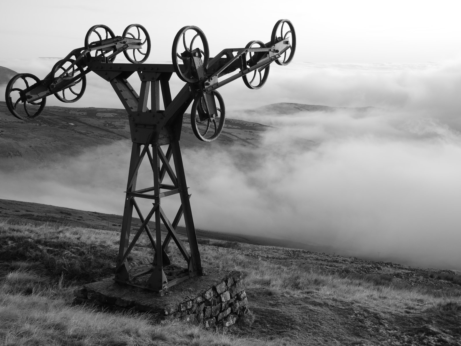
A lead and barytes mine high on Great Dun Fell, in the North Pennines, best known today for the remains of its aerial ropeway — at 1.75km the best-surviving example of its kind used in a metal-mining context anywhere in England, according to Historic England.
History
Lead has been mined in this part of the North Pennines since at least the 14th century, and during the 19th century the London Lead Company worked Silverband Mine, high on the south-western slopes of Great Dun Fell above Milburn, periodically for galena. A small quantity of barytes was raised between 1914 and 1918, but production increased dramatically once the La Porte Chemical Company took over the mine in 1939.
Almost immediately, La Porte installed an aerial ropeway to solve the problem of moving ore off an exposed fellside at over 700 metres: buckets suspended from a cable ran over at least seventeen iron pylons, descending the fell to a mill at Milburn Grange around 5km away, with the ropeway itself measuring some 5.6km in total; from Milburn Grange, a second ropeway carried the finished, dressed product on to Long Marton railway station. It replaced an earlier, cruder method of getting ore down the fell — an inclined plane, down which ore-filled trucks ran on rails, part of which survives running parallel to the ropeway's route. Between 1939 and 1963, Silverband produced 215,000 tons (211,603 tonnes) of dressed barytes ore. According to a Northern Mine Research Society study, parts of the ropeway were transferred in 1963 to the Aviemore Ski Centre in Scotland for reuse.
The mine closed and the ropeway was dismantled in the 1960s, but Silverband was worked again by opencast methods in the 1970s and 1980s, with ore milled on site and the product taken down the fell by lorry rather than by ropeway.
The Buddlepit database, drawing on Northern Mine Research Society records, lists the London Lead Company at Silverband from 1821 to 1879, the Silverband Mining Co. Ltd from 1884 to 1890, Bramall in 1914-18, the Silverband Syndicate in 1938, then B. Laporte Ltd from 1939 and Laporte Chemicals Ltd until the early 1960s. Laporte also worked the Hartside barytes mine and trucked its crude material to the Silverband plant until 1946, when a large deposit of barytes was found at Silverband itself. The ropeway was damaged by attempts to salvage and remove it when the mine closed in 1964. In March 2022 Natural England, whose Moor House National Nature Reserve includes the site, commissioned a survey of the brake house and ropeway ahead of a Conservation Management Plan, and the site is to be conserved.
Geology
Silverband lies in the North Pennine orefield, where barytes — a sulphate of barium — occurs as a vein mineral in association with lead, as it does across most of the major British lead orefields. The mine's earlier working was for galena, a sulphide of lead, before attention shifted to the associated barytes as demand for it grew through the 20th century.
Workings
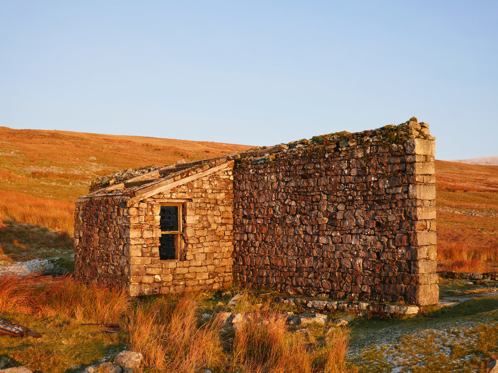
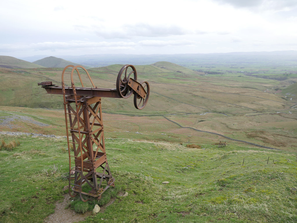
Ore was originally hauled down the fellside by an inclined plane, with trucks running on rails; this was superseded from 1939 by an aerial ropeway, buckets suspended from a cable running over at least seventeen iron pylons of at least two different designs — the best-preserved a Y-shaped type on a stone-and-concrete base, others simpler frames further up the fell. A stone-built brake house near the foot of the ropeway controlled its speed. Later working, after the mine's reopening, switched to opencast methods with ore processed at an on-site mill rather than sent down by ropeway.
Closure
The mine and its ropeway closed in the 1960s: Wikipedia gives 1966, the Archaeology Data Service 1964, and other accounts say the mine was worked until 1963. Silverband was later worked by opencast methods in the 1970s and 1980s, with ore then milled on site and taken down the fell by lorry.
What remains
A Scheduled Monument. The brake house has lost its roof and partly collapsed, and the ropeway was damaged when salvage was attempted at closure. A 2022 Historic England Level 2 survey found enough evidence of the original form and function of the features to interpret them, and the site is to be conserved. At least seventeen pylon positions survive in varying states, some toppled or twisted, others standing with wheel mechanisms intact.
Seventeen or more ropeway pylons in varying states of collapse, a partially standing stone-built brake house, sections of the earlier inclined plane's trackbed running parallel to the ropeway, and a mound of crushed ore of unknown function survive on the fellside; no comparable remains have been recorded at the former mill site at Milburn Grange.
Related mines
- Hartside Mine — Laporte trucked crude barytes from Hartside to the Silverband processing plant until 1946.
Nearby mines
- Upper Slatesike Mine — 2.9 miles (4.6 km) N
- Cash Well Mine — 3.3 miles (5.3 km) N
- New Stamphill Mine, Kirkby Thore — 3.5 miles (5.6 km) SW
- Kirkby Thore Gypsum Mines — 4.0 miles (6.5 km) SW
- Longriggs Mine, Appleby — 4.1 miles (6.6 km) SW
Straight-line distance, within 9 miles (15 km). Show on the map.
What's uncertain
Points where sources disagree or the record could not be settled; both accounts are kept. All open questions in the archive.
- The mine closed in 1964 according to the Archaeology Data Service and in 1963 according to the Buddlepit database. (disputed) 6,8
Recorded claims
Individual factual claims, each attached to the source(s) that support it below. Where sources disagree, both are kept.
- The London Lead Company worked Silverband Mine, on the south-western slopes of Great Dun Fell, periodically for galena during the 19th century, part of a wider tradition of lead mining in the area dating back to at least the 14th century. 1,2
- A small amount of barytes was raised between 1914 and 1918, but production increased dramatically once the La Porte Chemical Company took over the mine in 1939, going on to produce 215,000 tons (211,603 tonnes) of dressed barytes ore between 1939 and 1963. 1
- An aerial ropeway installed by La Porte almost immediately after their 1939 takeover used buckets on a cable running over at least seventeen iron pylons to move ore off the fellside, superseding an earlier inclined plane down which ore-filled trucks ran on rails; a stone-built brake house controlled the ropeway's speed. 1
- The ropeway ran a total of some 5.6km down to a mill at Milburn Grange, from where a second ropeway carried the finished product on to Long Marton railway station; parts of the ropeway were transferred to the Aviemore Ski Centre in Scotland in 1963, according to a 2011 Northern Mine Research Society study. 3
- The mine and ropeway closed in the 1960s (1966, per Wikipedia's account of Great Dun Fell), before Silverband reopened later in the 20th century and was worked intermittently by opencast methods, ore then being milled on site and taken down the fell by lorry. 4,5
- The surviving ropeway, brake house and inclined plane are a Scheduled Monument, which Historic England describes as the best-surviving example of an aerial ropeway used in a metal-mining context in England. 1
- The London Lead Company worked Silverband from 1821 to 1879, the Silverband Mining Co. Ltd from 1884 to 1890, and B. Laporte Ltd from 1939, succeeded by Laporte Chemicals Ltd. 6
- Silverband was worked by opencast methods in the 1970s and 1980s. 6,7
- The mine closed in 1964 according to the Archaeology Data Service and in 1963 according to the Buddlepit database. (disputed) 6,8
- The ropeway was damaged by attempts to salvage and remove it when the mine closed. 8
- In March 2022 Natural England commissioned a survey of the brake house and ropeway ahead of a Conservation Management Plan; the digital archive was released in February 2023. 8
- Laporte trucked crude barytes from the Hartside mine to the Silverband processing plant until 1946, when a large deposit was found at Silverband. 9
- The British Geological Survey catalogues plans and sections of Silverband Mine, including a 1847 plan of the lead mine. 10
Photographs & further reading
Note on the 2022 Historic England Level 2 survey of the scheduled ropeway and brake house and its online archive.
View sourceDatabase entry with owners from 1821 to 1962, grid reference and references to the mine's literature.
View sourceGazetteer entry for the mine at Milburn on Great Dun Fell.
View sourceSources
- (primary) Silverband mine aerial ropeway, brake house and inclined plane, Milburn — Historic England (Scheduled Monument listing 1021009)
- (secondary) Silverband Mine — co-curate.ncl.ac.uk (Newcastle University)
- (secondary) Silverband Mine aerial ropeway, Great Dun Fell — Geograph Britain and Ireland (James T M Towill, citing Smith & Murphy 2011, British Mining No. 91, NMRS)
- (secondary) Barytes — Industrial History of Cumbria
- (secondary) Great Dun Fell — Wikipedia
- (secondary) Silverband Mine - Buddlepit Mine Database — Buddlepit Mine Database
- (secondary) Old Cumbria Gazetteer - Silverband Mine, Milburn — Old Cumbria Gazetteer
- (secondary) Collection Feature: Silverband Mine Brake House and Aerial Ropeway (Archaeology Data Service) — Archaeology Data Service
- (observational) Report - Mines 54 - Hartside Barytes Mine (Cumbria 2025) (28DaysLater) — 28DaysLater
- (primary) BGS / Mining Remediation Authority mine plans: SILVERBAND MINE (item 18930) — British Geological Survey
Record created: 27 August 2026 · Last researched: 30 September 2026