 MineArchive
Seathwaite Wad Mine
| Location | Seathwaite, Borrowdale, Cumbria — 54.5024, -3.1867 (exact) |
|---|---|
| Commodity | Graphite |
| Type | Mineral |
| Worked | 15th century (earliest indirect evidence)–1891 |
| Maximum depth | shallow, following graphite pockets |
Overview
The world's first significant source of commercial graphite, mined on a remote Borrowdale fellside from at least the 16th century — a deposit so pure, and so valuable, that Parliament made stealing it a felony.
History
Graphite was being extracted at Seathwaite by the early 16th century at the latest, with the earliest firm documentary references dating from 1540-41 and indirect evidence pushing plausible working back into the 15th century. Known locally as 'wad' — also called plumbago or black lead — it had long been used by Cumberland farmers to mark sheep before its real value was recognised: uniquely pure, solid graphite that could be sawn into sticks, it made vastly better crucible linings and, from the 1560s, the first true pencils. Its earliest major industrial use, though, was military — moulding smoother, more accurate cannonballs — reportedly giving the Royal Navy a real edge in gunnery over less well-supplied rivals. Wad's value rose so high — some thirty shillings a pound by 1779 — that theft and armed raids on the mine became a serious problem, leading Parliament to pass an act in 1752 making the theft of graphite a felony, and mine owners to employ armed guards and strip-search departing workers. The Keswick pencil industry, which grew into the world-famous Derwent Pencils firm, was built directly on Seathwaite's graphite. Production expanded through the 18th and early 19th centuries, including a purpose-built grinding mill from 1887 to process lower-grade material recovered from Robson's Level, but the deposit was worked out and the mine finally abandoned in 1891.
Geology
The graphite occurs as an unusual and highly localised association with volcanic rock, in veins and nodules linked to chlorite within the Borrowdale Volcanic Group — a formation process not clearly duplicated anywhere else in Britain, which is why the deposit's purity was never matched elsewhere in the country.
Workings
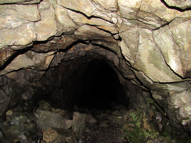
Workings followed the graphite pockets and veins as shallow levels driven into the fellside, of which Gilbert's Level — driven 1798-1800 to drain the main body of the mine — is the best known, with the remains of a guard lodge still visible at its entrance. The site also includes a grinding mill, a sawpit, guardhouses, spoil heaps and trackways.
Closure
Production expanded through the 18th and early 19th centuries, a purpose-built grinding mill being added from 1887.
What remains
The site is owned by the National Trust, and several of the old workings remain open. A 2021 exploration report recorded roughly 75 yards of passage beyond the main entrance, with further sections beyond that.
The grinding mill, guardhouses, spoil heaps, trackways and several open adits survive as a scheduled monument, alongside boundary stones marking the site's historic extent.
Nearby mines
- Dubs Quarry — 0.7 miles (1.1 km) NW
- Honister Slate Mine — 0.7 miles (1.1 km) NW
- Yew Craggs Quarry — 0.9 miles (1.4 km) N
- Rigg Head Quarry — 1.7 miles (2.8 km) N
- Bank Wood Quarry — 2.1 miles (3.3 km) NE
Straight-line distance, within 9 miles (15 km). Show on the map.
Recorded claims
Individual factual claims, each attached to the source(s) that support it below. Where sources disagree, both are kept.
- A December 2021 exploration report described roughly 75 yards of easy walk-in passage from the main entrance, small crawl-throughs, and further roped sections reaching worked-out graphite veins, with some passages avoided due to steep drops. 1
- The Geological Conservation Review site at NY 234 127 records graphite as replacement mineralisation in a dolerite intrusion into the Borrowdale Volcanic Group, in eight veins and inclined pipes one to three metres across running from two to over a hundred metres deep, confined to 400 metres of the vein system and richest at the junction with the volcanic rocks; the deposit is remarkably pure, with no counterpart in Britain or elsewhere, and the mine, worked from 1540 to final abandonment in 1891, was probably the world's first commercial producer of graphite. 2
- The British Geological Survey holds a surface plan of the black lead mines at Seathwaite from the Cumbria Amenity Trust's collection (CT264), which can be viewed online. 3
- In the seventeenth century the mine was worked only for short periods to keep supplies short and prices high, yet Borrowdale became the world's leading supplier; Laurence Nowell used its graphite on a map of about 1565-6 now in the British Library. 4
Photographs & further reading
The scanned surface plan, viewable online.
View sourceSources
- (observational) Mines 10 - Borrowdale Graphite (Cumbria, Dec, 2021) — 28DaysLater
- (secondary) Seathwaite Graphite Mine, Cumbria — GeoGuide (Scottish Geology Trust)
- (primary) Plan of the black lead mines at Seathwaite in Borrowdale, CT264 (BGS mine plans catalogue, Cumbria Amenity Trust collection) — British Geological Survey
- (secondary) The Seathwaite Plumbago Mine Background Above Derwent — Cumbria County History Trust
- (primary) Borrowdale graphite mines and associated grinding mill, 660m north west of Seathwaite, Borrowdale — Historic England
Record created: 21 August 2026 · Last researched: 24 September 2026