 MineArchive
Saltwick Nab Alum Quarries
| Also known as | Saltwick Alum Works |
|---|---|
| Location | Saltwick Bay, near Whitby, North Yorkshire — 54.4883, -0.5887 (approximate) |
| Commodity | Alum |
| Type | Quarry |
| Worked | 1649–1791 |
| Maximum depth | A quarry face 35 m high; there were no underground workings. |
| Operators | Sir Hugh Cholmley (1649–?) |
Overview
Alum shale quarries on the headland at the west end of Saltwick Bay, two kilometres east of Whitby, opened in 1649 and worked on and off until 1791. The quarry face, its steeping pits and cisterns, and a stone slipway on the foreshore survive; the alum house of 1770 to the east is being taken by the sea.
History
Alum was first quarried at the west end of Saltwick Bay in 1649 — the first recorded quarrying being by Sir Hugh Cholmley of Whitby Abbey — and work continued intermittently until it ceased in 1791. For most of that time the quarry was only the first stage of the process: the shale was calcined in heaps on the site and steeped in stone-lined pits, and the raw liquor was shipped to South Shields to be made into alum, until an alum house was built east of the quarry in 1770 and the liquor could be sent to it along timber troughs. Quarries were opened on the promontories at both ends of the bay, the western and earlier one being the site now scheduled. Digging into the cliff turned up the fossils the bay is now known for, and a horse skeleton found some thirty yards underground in the workings about 1764 was recorded in the histories of Whitby. Work stopped in 1791, more than half a century before the Yorkshire alum trade as a whole gave way to cheaper sources.
Geology
The quarry was cut into the north slope of the headland through the Lower Jurassic cliffs of the Whitby district, the lower 20 m of its 35 m face being the grey alum shale. The same beds are rich in ammonites and marine reptiles, and the bay gives its name to the Saltwick Formation.
Workings
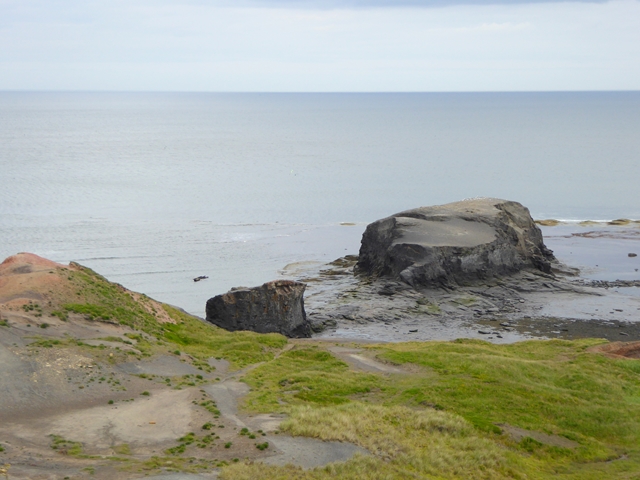
The working face runs up to 180 m along the headland and stands 35 m high, with a terrace at its foot marking the last stage of quarrying. On the quarry floor are areas of burnt shale from calcination, stone-lined steeping pits on the east side, and the remains of workshops, offices, stores and a laboratory. On the foreshore south of the promontory is a slipway of large stone blocks, no longer joined to the land, with rutways worn by horse-drawn waggons running out across the intertidal rock on either side.
Closure
Quarrying ceased in 1791. The alum house built in 1770 stood only twenty years in use and its remains are now being destroyed by coastal erosion.
What remains
The quarry face and floor, and the slipway, are a scheduled monument in two areas; the alum house is not scheduled because the sea is destroying it. A 2011 visitor account notes the red of burnt shale across the site, a stone ramp on the shore, and the remains of buildings and wooden pits on the flat ground inland of the Nab, all heavily eroded and hard to read on the ground though clear on the first-edition Ordnance Survey maps.
The quarry face and terrace, spreads of burnt shale, stone-lined steeping pits, building footings on the quarry floor, the stone-block slipway and the waggon rutways on the foreshore.
Redevelopment
None. The headland is open cliff top and foreshore.
Nearby mines
- Whitby Jet Workings — 2.1 km W
- Woodsmith Mine — 6.7 km S
- Aislaby Quarry — 6.9 km W
- Goldsborough Ironstone Mine — 8.2 km W
- Kettleness Alum Works — 9.6 km NW
Straight-line distance, within 15 km. Show on the map.
Recorded claims
Individual factual claims, each attached to the source(s) that support it below. Where sources disagree, both are kept.
- Alum was first quarried at the west end of Saltwick Bay in 1649 and this continued intermittently until operations ceased in 1791. 1,2
- The first recorded quarrying at Saltwick Bay was by Sir Hugh Cholmley of Whitby Abbey in the 17th century. 2
- The alum house was erected in 1770 to the east of the quarry; before that the alum liquor was shipped to South Shields for processing. 1,3
- The quarry face is up to 180 m long and 35 m deep, the lower 20 m in grey alum shale. 1,2
Photographs & further reading
A short 2011 site visit with photographs of the burnt shale, the shore ramp and the eroded remains inland of the Nab.
View sourceSources
- (primary) Saltwick Nab alum quarries, Hawsker-cum-Stainsacre (List entry 1017779) — Historic England
- (secondary) Saltwick Bay — Wikipedia
- (observational) Saltwick Nab – Alum Quarry — Hidden Teesside
Record created: 22 September 2026 · Last researched: 22 September 2026