 MineArchive
Rheidol United Mines
| Also known as | Rheidol United Mine, Nantglas Mine, Erwtomau Mine, Rhiwrugos Mine, Alltddu Mine |
|---|---|
| Location | South side of the Rheidol valley, a little above Rheidol Falls, Ceredigion |
| Commodities | Lead, Zinc |
| Type | Metal |
| Worked | 1853–1925 |
| Maximum depth | 63 fathoms (the Nantglas deep adit level, about 115 m) |
The Rheidol United mines were a group of at least five sets of lead and zinc workings on four lodes, on the south side of the Rheidol valley a little above Rheidol Falls. They lay nearly due west of Caegynon. Worked separately as Nantglas, Gwaithgoch, Rhiwrugos and Alltddu, they made returns under the united name from 1855 to 1889. The Rhiwrugos workings were reopened for blende as the Erwtomau mine in the early twentieth century, and the last plans were abandoned in 1925.
History
Four lodes cross the hillside here, and each had its own mine before they were worked as one. Nantglas, the chief of them, was stoped from two cross-cut adits right up to the surface. A report of 1858 found its lode 20 to 26 feet wide at the deep adit but split up, hard, and carrying only strings of lead ore with blende and spar, not enough to pay. Gwaithgoch, beside it on the north-east, worked a shoot of ore from two more cross-cuts, the upper of which was carried on for nearly 120 fathoms to reach the Rhiwrugos lode.
The earliest returns are from the outliers of the group: Penclayen in 1853 and Foxpath from 1853 to 1855. Under the name Rheidol United lead ore was returned from 1855 to 1861, 1865 to 1868, in 1876 and 1877 and from 1882 to 1889, 584 tons in all, with small parcels under the name Gothic in the 1860s.
Rhiwrugos was different. The same report of 1858 found far more blende there than galena, two tons and more to the fathom, at a time when it was lead that was wanted. Years later the adit was reopened to take out the blende that had been left standing, and the workings became known as the Erwtomau mine, which made small returns of lead ore in 1915 and 1916. The plans of the Rheidol United mines were deposited as abandoned in 1925.
Geology
From north to south the lodes are Gwaithgoch, running east and west and dipping north at 70 to 75 degrees; Nantglas, parallel and about 60 yards south, traced for more than three-quarters of a mile; Rhiwrugos, striking west-south-west and dipping north at about 80 degrees; and Alltddu, the least important, which alone dips south. A fault cuts the Nantglas and Gwaithgoch lodes near the railway, and Nantglas was not productive east of it. All three main lodes converge towards Caegynon, and the great south-dipping Castell lode, which ought to pass this way, has never been met in any of the cross-cuts.
Geological setting: Veins and Lodes (well documented example)
Workings
Nantglas was worked from an upper adit, at about 730 feet above sea level, and a deep adit at about 380 feet, the 63-fathom level; its ore body, 60 to 80 fathoms long near the surface, narrowed quickly downward. Gwaithgoch has an upper cross-cut at about 320 feet and a deep adit, the 52-fathom level, at about 250 feet. On the Rhiwrugos lode an upper adit at about 480 feet was driven some 100 fathoms west, with a winze and a 10-fathom level below it joined to the Gwaithgoch cross-cut, and a deep adit was driven 90 fathoms from the level of the river with an engine shaft 12 fathoms below it. Alltddu has two adits and a shaft. A long cross-cut, the Foxpath, was driven to the Nantglas lode further west.
Closure
The last return under the name Rheidol United is for 1889 and the last from Erwtomau for 1916; the mine plans are catalogued as abandoned in 1925.
What remains
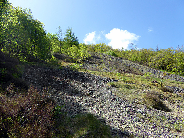
Banks of bare grey mine spoil lay among the trees on the valley side in 2018, on the ground of the old Gwaithgoch mine.
Spoil tips and the open-cut workings on the outcrop of the Rhiwrugos lode.
Further reading
The catalogue entry for the sections of the Gwaith Coch, Nantglas, Rhiwrugos and Alltddu lodes held by the British Geological Survey.
View sourceSources
- (primary) Lead and Zinc: The Mining District of North Cardiganshire and West Montgomeryshire (Special Reports on the Mineral Resources of Great Britain, vol. XX), O. T. Jones, 1922 — Memoirs of the Geological Survey
- (primary) Mine plan: Sections of the Rheidol United Mines lodes, Cardiganshire (Gwaith Coch, Nantglas, Rhiwrhugus, Rhiwrhugus South and Allt a Du lodes) — British Geological Survey
- (primary) Mine plan: Rheidol United Mines, abandoned 1925 (KP23331) — British Geological Survey
- (observational) Mining spoil, Rheidol United mine (Geograph photograph 5771789, 2018) — Geograph
Record created: 18 November 2026 · Last researched: 18 November 2026