 MineArchive
Ramsley Mine
| Location | South Zeal, near Okehampton, Devon — 50.7260, -3.9110 (approximate) |
|---|---|
| Commodity | Copper |
| Type | Metal |
| Worked | Trial working from 1851; main development from 1858–c.1911-12 |
| Maximum depth | Engine (Lamberts) Shaft reached 170 fathoms below adit |
| Operators | Fursdon Mining Company (1859–1870) |
Overview
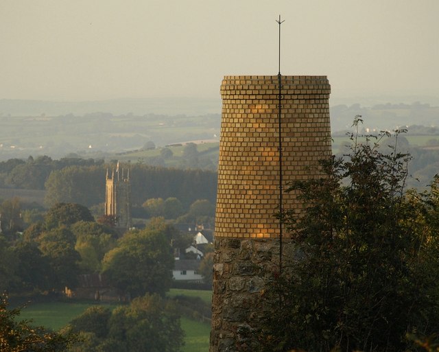
A Dartmoor-fringe copper mine above South Zeal, worked under a shifting cast of companies from 1851 to 1912, whose lodes were split from those of neighbouring Belstone Mine by movement on the Sticklepath Fault — and whose surviving chimney, brought down by a lightning strike in 1998, was rebuilt by the parish the same year.
History
Rich copper mineralisation was noticed at Ramsley Hill during construction of the Exeter-to-Okehampton turnpike road in 1829, but organised mining did not begin until 1851, when a local syndicate drove an exploratory adit and sank a shaft 10-20 fathoms deep; this first venture closed after only three years. The ground was tried again in 1856 as the Devon Copper and Silver Lead Mine, and more seriously from 1858 under the Ramsley Hill Mining Company Ltd, renamed the following year as the Fursdon Mining Company after George Fursdon, Lord of the Manor, who celebrated the installation of a 50ft waterwheel in February 1860 with a performance by the South Tawton Silver Band at the Oxenham Arms. Under resident manager Captain John Collins and managing director M.E. Jobling — presented with silver pieces in 1870 in recognition of his management — the mine grew steadily: 45 workers and a 45-fathom shaft by 1862, a 55-fathom shaft and 45ft crushing wheel by 1868. The Fursdon Great Consolidated Mining Company took over in 1870, and the concern was renamed again in 1876 as Wheal Emily, before that company was wound up in 1883. Further reincarnations followed in quick succession — Emily Copper Mines from 1881, Emily Copper Mines Ltd from 1882, South Tawton Copper Mines Ltd from 1888 — before the Ramsley Exploration Company took over in January 1900 and drove the mine's most productive final phase, raising 3,752 tons of copper ore worth almost £21,000 between 1901 and 1909 with a workforce of around 60, split evenly between surface and underground work. Mining finally ended around 1911-12; a 1916 inspection found the site still being looked after, with notices warning against damage, and by 1920 much of the surface plant — a winding house with its steam engine, headgear, and the Cornish lift pump's waterwheel — survived in fair condition, though the connecting rods and balance bobs had been removed for scrap in the intervening years. The ground was briefly prospected again in 1951, without result. The mine's most distinctive surviving feature, a tapered brick chimney on Ramsley Common that once carried fumes from the mine's steam engine — and doubled, via the connecting flue running through an adjoining shed, as a place for miners to dry their wet clothes — was itself struck by lightning on 3 January 1998, scattering stone and brick over a wide area and leaving the remains unsafe; South Tawton Parish Council had it rebuilt the same year.
Geology
Ramsley Hill sits east of the Sticklepath Fault, on a spur of Dartmoor granite at its junction with the surrounding killas (clay slate) of the Carboniferous Lower Culm Measures. Its three principal lodes — North, Middle and South, running broadly east-west — are the same mineralised beds worked at neighbouring Belstone Mine, but displaced from them by movement on the Sticklepath Fault: the Greenhill section of the lode system slid north while the Ramsley section slid south, leaving the two related deposits separated by roughly 2,000 yards along the fault line. Ore minerals recovered included chalcopyrite, arsenopyrite (mispickel) and pyrite, typically yielding 4-5% copper, alongside axinite and actinolite in the mine's spoil.
Workings
A deep shaft mine developed through two principal shafts — the Engine (or Lamberts) Shaft, reaching 170 fathoms below adit level, and the Western (or Joblings) Shaft, 73 fathoms deep some 70 fathoms to the west-southwest — worked via an adit itself sunk 32 fathoms below surface. Power came from a succession of waterwheels fed by a leat carried across the Throwleigh road on an aqueduct, supplemented from 1900 by steam power in dry seasons; surface plant included a winding house, boiler house, sawmill for underground timber, powder house and, from the 1900s, covered dressing floors.
Closure
Mining ended around 1911-12; the site was still being maintained as late as 1916, and much of its surface plant survived into the 1920s before being progressively stripped for scrap. A brief prospecting attempt in 1951 came to nothing.
What remains
A tapered brick chimney stack on Ramsley Common, east of the main workings, remains the site's most visible feature — struck by lightning on 3 January 1998 and rebuilt the same year by South Tawton Parish Council. Shaft remnants, one or two ruined buildings, and extensive reddish-brown spoil heaps sloping toward the road survive nearby, though the old leat is now dry and only faintly traceable.
The rebuilt chimney stack, shaft remnants, ruined buildings and spoil heaps survive on Ramsley Common above South Zeal; Dartmoor's Sticklepath Fault split the same mineral lodes worked here as at neighbouring Belstone, and the derelict brick flues are still crusted white with mineral deposits.
Nearby mines
- Meldon Quarry — 8.7 km W
- Golden Dagger Mine — 13.6 km S
- Vitifer Mine (Birch Tor and Vitifer) — 14.4 km S
Straight-line distance, within 15 km. Show on the map.
The old shafts and ruined buildings are hazardous — this entry describes history and general location only, not an access guide.
What's uncertain
Points where sources disagree or the record could not be settled; both accounts are kept. All open questions in the archive.
- A Mining Remediation Authority abandonment plan for Ramsley, seam 'Copper Ore', gives an abandonment date of 9 December 1909 -- earlier than, but broadly consistent with, the wider c.1911-12 closure given by the mine's other sources; the plan most likely records a specific shaft or section abandoned while work continued elsewhere on the site for a further two years. (uncertain) 4
Recorded claims
Individual factual claims, each attached to the source(s) that support it below. Where sources disagree, both are kept.
- An exploratory adit and shaft were driven from 1851 by a local syndicate, closing after three years; renewed working from 1858 under the Ramsley Hill Mining Company, renamed the Fursdon Mining Company in 1859 after Lord of the Manor George Fursdon. 1,2
- Ramsley's North, Middle and South lodes are the same mineralised beds worked at Belstone Mine, displaced by around 2,000 yards through movement on the Sticklepath Fault. 1
- Under the Ramsley Exploration Company from 1900 the mine raised 3,752 tons of copper ore worth almost £21,000 between 1901 and 1909 with a workforce of around 60; mining ended around 1911-12. 1,2
- The mine's chimney stack on Ramsley Common was severely damaged by a lightning strike on 3 January 1998, scattering debris over a wide area, and was rebuilt by South Tawton Parish Council the same year. 3
- A Mining Remediation Authority abandonment plan for Ramsley, seam 'Copper Ore', gives an abandonment date of 9 December 1909 -- earlier than, but broadly consistent with, the wider c.1911-12 closure given by the mine's other sources; the plan most likely records a specific shaft or section abandoned while work continued elsewhere on the site for a further two years. (uncertain) 4
Photographs & further reading
Devon Historic Environment Record entry for the mine.
View sourceSouth Tawton local history account of the mine.
View sourceSources
- (secondary) Ramsley Mine (Gerald Bastable) — South Tawton and District Local History Group
- (secondary) Ramsley Mine — Mining in Devon Database
- (primary) Ramsley Copper Mine (MDV6940) — Devon Historic Environment Record
- (primary) BGS/Mining Remediation Authority abandonment plan: RAMSLEY (Copper Ore) — Mining Remediation Authority (via BGS OGC API)
Record created: 27 August 2026 · Last researched: 27 August 2026