 MineArchive
Monktonhall Colliery
| Location | Danderhall / Millerhill, Midlothian — 55.9205, -3.0872 (exact) |
|---|---|
| Commodity | Coal |
| Type | Coal |
| Worked | 1953 (sinking)–April 1997 |
| Maximum depth | c. 1,000m (two shafts) |
| Operators | Waverley Mining Finance (1994–1997) |
Overview
A National Coal Board colliery near Danderhall, Midlothian, sunk from 1953 and opened in 1965, at its peak served by daily trains to both Cockenzie and Longannet power stations. Closed in 1989, it was reopened in June 1992 by its own miners as a co-operative — one of the more remarkable episodes of the post-nationalisation coal industry — before financial difficulty and flooding from older workings finally ended production in April 1997. A proposed scheme to heat the new Shawfair development using the flooded mine's warm water was later abandoned.
History
Sinking of Monktonhall's two shafts began in 1953, and the colliery was opened by the National Coal Board in 1965, on the west side of the newly built Millerhill Marshalling Yard. At its productive height the colliery ran eight trains a day of coal to Cockenzie Power Station and two a day to Longannet, with 1969 recorded as its peak year of output. The colliery closed in 1989 as it became increasingly difficult to sell its coal to the South of Scotland Electricity Board, though the site was not demolished.
What followed was, in the words of one contemporary account, 'both unusual and very impressive': in June 1992, using redundancy and other money, the colliery's own miners leased the mine and formed a co-operative, reopening and working it for two years as one of Britain's few miner-owned deep coal mines. In 1994 the venture was taken over by Waverley Mining Finance. The colliery finally closed in April 1997, defeated by water flooding in from older, adjacent workings; its closure left Longannet as the only working colliery in Scotland. The No. 2 winding tower was demolished in November 1997, followed by the No. 1 tower in February 1998, and the wider site has since been cleared.
The colliery's flooded underground workings were later examined as a possible source of geothermal heat for Shawfair, a new town planned largely on the former colliery site. A feasibility study found genuine potential in using mine water and heat-pump technology for a scheme to warm homes, and a 2003 grant application to the European Commission secured £3.5 million; the temperature at the workings' 1,000-metre depth is around 25°C, which heat pumps could raise to 40-60°C. Further UK and Scottish government funding applications failed, however, in part over unresolved questions of who owned the mine water as an energy resource, and the scheme was abandoned. The Coal Authority has continued an ongoing commitment to pumping mine water from Monktonhall to control water levels in the flooded workings.
Geology
Coal of the Midlothian field: the Four Foot (Claiknowes), Splint, Parrot and other seams recorded in the abandonment plans. The mine water carries enough iron to stain the settling ponds rust-coloured.
Workings
The colliery was worked from two shafts sunk to around 1,000 metres, giving access to an underground footprint of some 11 square kilometres. The BGS/Coal Authority mine plans catalogue records plans for the Four Foot (Claiknowes), Splint (recorded jointly as Stoneyhill/Monktonhall), Parrot, Peacock and Gillespie seams, together with a separate 'Inveresk/Monktonhall — Old Shafts' record indicating the site incorporated or overlapped older workings pre-dating the 1953-65 sinking.
Closure
Closed in 1989 as it became increasingly difficult to sell its coal to the South of Scotland Electricity Board.
What remains
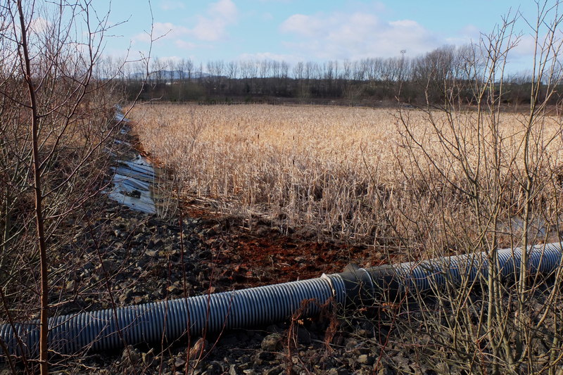
A 2013 observational report described dry settling ponds and reed beds left rust-coloured by the iron content of the mine water, a derelict lime-dosing building stripped of most equipment, and the main shaft, water-filled and not fully capped. The adjoining former Millerhill marshalling yard sidings were by then derelict and reclaimed by self-seeded birch woodland. The wider site has since been developed as part of the Shawfair new town.
Nearby mines
- Woolmet Colliery — 1.0 miles (1.6 km) SW
- Newcraighall Colliery — 1.0 miles (1.7 km) N
- Niddrie Colliery — 1.1 miles (1.8 km) NW
- Gilmerton Colliery — 2.0 miles (3.2 km) SW
- Smeaton Colliery — 2.0 miles (3.3 km) E
Straight-line distance, within 9 miles (15 km). Show on the map.
Recorded claims
Individual factual claims, each attached to the source(s) that support it below. Where sources disagree, both are kept.
- Sinking of the colliery's two shafts began in 1953; it was opened by the National Coal Board in 1965, on the west side of the newly built Millerhill Marshalling Yard. 1
- The colliery closed in 1989 without being demolished; in June 1992 its own miners leased the mine using redundancy and other funds, forming a co-operative that reopened and worked it for two years before Waverley Mining Finance took over in 1994. 1
- The colliery closed in April 1997, defeated by water flooding in from older adjacent workings; its closure left Longannet as Scotland's only working colliery. The No. 2 winding tower was demolished in November 1997 and the No. 1 tower in February 1998. 1
- A feasibility study found potential for a community heating scheme using minewater and heat-pump technology from the flooded colliery, with a 2003 EC grant of £3.5 million secured; further UK and Scottish government funding failed, in part over ownership of the mine water as an energy resource, and the scheme was abandoned. 2
- The BGS/Coal Authority mine plans catalogue holds records for the Four Foot, Splint, Parrot, Peacock and Gillespie seams, plus a separate record for older shafts pre-dating the 1950s-60s sinking. 3
Sources
- (secondary) Monktonhall Colliery — RAILSCOT
- (primary) Potential for Deep Geothermal Energy in Scotland: study, volume 2 — Scottish Government
- (primary) Monktonhall mine plan records — British Geological Survey / Coal Authority mine plans catalogue
Record created: 26 August 2026 · Last researched: 26 August 2026