 MineArchive
Loscoe Colliery
| Also known as | Old Loscoe |
|---|---|
| Location | Loscoe, near Heanor, Derbyshire — 53.0227, -1.3701 (exact) |
| Commodity | Coal |
| Type | Coal |
| Worked | c.1830 (sinking)–1933 |
| Maximum depth | Unknown. |
| Operators | Goodwin and Griffin (1830–1840), E. D. Whittingstall (1840–1856), Butterley Company (1856–1933) |
Overview
A pit at Loscoe, near Heanor, sunk by Goodwin and Griffin in the early 1830s to the Deep Hard and Deep Soft seams, worked by the Butterley Company from 1856 and closed in 1933 when the seams were exhausted.
History
Loscoe Colliery was sunk in the early 1830s by Goodwin and Griffin to work the Deep Hard and Deep Soft seams. It was taken over in 1840 by E. D. Whittingstall and in 1856 by the Butterley Company, which added it to its growing group of collieries; a Midland Railway branch served it from the Langley Mill to Heanor and Ripley line. With Ormonde, Bailey Brook and New Langley it later formed the Butterley Company's group known as the New Langley Collieries. In 1849 three men were killed in a shaft accident, and in 1852 two died when a pit rope broke (see Disasters, below).
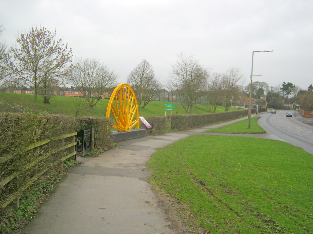
Through the 1890s and 1900s the colliery employed between about 240 and 310 men in the Deep Soft and Deep Hard seams, rising to 330 in 1923. When the Butterley Company sank Ormonde Colliery in 1906, its two shafts were put down through the old Deep Soft and Deep Hard workings of Loscoe Pit. Loscoe Colliery closed in 1933, its seams exhausted: the abandonment plans of its Deep Hard and Deep Soft workings are dated 4 August 1933. It was one of the three pits, with Bailey Brook and Ormonde, that made Loscoe a mining village, and its site is now common land, with a winding-wheel memorial beside Heanor Road.
Geology
The Deep Hard and Deep Soft seams of the Derbyshire coalfield.
Workings
Shafts to the Deep Hard and Deep Soft seams, served by a Midland Railway branch from the Langley Mill to Heanor and Ripley line.
Closure
Closed in 1933 when the seams were exhausted; the Deep Hard and Deep Soft were abandoned on 4 August 1933.
What remains
The site is common land beside the Red River nature area.
A winding wheel erected as a memorial to the colliery beside the A6007 Heanor Road.
Redevelopment
Common land.
Related mines
- Ormonde Colliery — Ormonde's shafts were sunk in 1906 through Loscoe Pit's old Deep Soft and Deep Hard workings; both Butterley Company pits at Loscoe.
Nearby mines
- Ormonde Colliery — 0.2 miles (0.4 km) E
- Denby Hall Colliery — 1.0 miles (1.7 km) W
- Ripley Colliery — 1.9 miles (3.1 km) NW
- Brinsley Colliery — 2.7 miles (4.3 km) E, Nottinghamshire
- Britain Colliery — 2.8 miles (4.5 km) N
Straight-line distance, within 9 miles (15 km). Show on the map.
Disasters & major incidents
-
Loscoe Colliery rope accident, 1852
5 October 1852 · Winding / Shaft Accident · 2 fatalities
An iron splicing-plate in the hemp winding rope at E. F. Whittingstall's Loscoe Colliery, near Heanor, snapped over the pulley on 5 October 1852, dropping the cage and two men down the shaft; the safety catch failed to hold it.
Recorded claims
Individual factual claims, each attached to the source(s) that support it below. Where sources disagree, both are kept.
- Sunk by Goodwin and Griffin in the early 1830s to work the Deep Hard and Deep Soft seams; taken over by E. D. Whittingstall in 1840 and by the Butterley Company in 1856. 1
- Closed in 1933. 2,1,3
- The Deep Hard and Deep Soft workings were abandoned on 4 August 1933. 4
- Ormonde Colliery's shafts, sunk in 1906, passed through the old Deep Soft and Deep Hard workings of Loscoe Pit. 2
- Employed 246 in 1894, 294 in 1910 and 330 in 1923, working the Deep Soft and Deep Hard seams for the Butterley Company. 5
- Formed part of the Butterley Company's New Langley Collieries with Ormonde, Bailey Brook and New Langley. 6
- Loscoe was a mining village whose three mines were Old Loscoe, Bailey Brook and Ormonde. 7
Sources
- (observational) Loscoe Colliery Memorial (Geograph 3748961) — Geograph
- (secondary) Ormonde Colliery — Heanor and District Local History Society
- (observational) Byway at Loscoe Fields (Geograph 3762617) — Geograph
- (primary) BGS mine plan: Loscoe, Ormonde, Robey Fields, Deep Hard (abandoned 4 August 1933) — British Geological Survey / Mining Remediation Authority
- (primary) Loscoe Colliery — Durham Mining Museum
- (secondary) Loscoe Colliery (Picture the Past DCAV000348) — Picture the Past
- (secondary) Loscoe — Heanor & District Local History Society
Record created: 17 October 2026 · Last researched: 17 October 2026