 MineArchive
Longwitton Colliery
| Also known as | Long Witton Colliery |
|---|---|
| Location | North-west of Longwitton, near Hill Top, Northumberland — 55.2002, -1.9002 (approximate) |
| Commodities | Coal, Fireclay |
| Type | Coal |
| Worked | c. 1874–before 1897 |
| Maximum depth | Unknown. |
| Operators | Longwitton and Greenleighton Coal and Lime Company Ltd, Sir W. C. Trevelyan, Cecil Spencer Percival, William Wilkinson |
Overview
A small Trevelyan estate colliery north-west of Longwitton, worked from the 1870s by the Longwitton and Greenleighton Coal and Lime Company and linked by tramway to Longwitton station; it raised coal and fireclay and was disused by 1897.
History
Longwitton Colliery lay north-west of Longwitton, near Hill Top, in Hartburn parish near Morpeth. Nothing is marked on the site on the Ordnance Survey six-inch map of 1863. The Longwitton and Greenleighton Coal and Lime Company was set up about 1874 to work the colliery together with Greenleighton quarry and lime works. Sir W. C. Trevelyan owned the colliery, and later Cecil Spencer Percival; the North of England mining institute's Forster papers hold three volumes of letters and plans about it from 1874 to 1894, much of them with Thomas Gow, the Trevelyans' agent.
A tramway linked the colliery to the railway at Longwitton station, at Rothley Shield East on the Rothbury branch. The station had opened in 1870 as Rothley, a private halt for the Trevelyan estate, and took the name Longwitton in 1875; it served a limestone quarry and a colliery into the 1920s.
The company was still recorded as running the pit in the 1880s. It raised coal and fireclay in 1882 and coal for landsale in 1888. A plan of the workings in the Longwitton seam is dated June 1886, and the colliery's abandonment plan appears in the list of 1893. William Wilkinson is named as owner in the 1890s. The 25-inch Ordnance Survey of 1897 marks the colliery as disused, as does the edition of 1921. There were colliery buildings and miners' cottages, and aerial photographs show a number of coal shafts to the north and west.
Geology
The Longwitton seam.
Workings
Shafts, with a number of further coal shafts to the north and west of the colliery buildings.
Closure
A plan of the Longwitton seam is dated June 1886 and the abandonment plan is in the 1893 list; the colliery is shown disused on the 1897 Ordnance Survey.
What remains
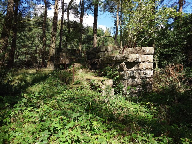
Stone remains of the colliery stand in woodland.
Masonry walls among trees; aerial photographs show a number of coal shafts to the north and west.
Nearby mines
- Chirm Colliery — 4.4 miles (7.1 km) NE
- Forrestburn Colliery — 4.6 miles (7.4 km) N
- Healey Cote Colliery — 7.4 miles (12.0 km) NE
- Kirkheaton Colliery — 8.0 miles (12.8 km) S
- Elsdon Colliery — 8.3 miles (13.4 km) W
Straight-line distance, within 9 miles (15 km). Show on the map.
Recorded claims
Individual factual claims, each attached to the source(s) that support it below. Where sources disagree, both are kept.
- The Longwitton and Greenleighton Coal and Lime Company, set up about 1874, worked Longwitton Colliery and was recorded running it in the 1880s. 1,2,3
- A tramway linked Longwitton Colliery to the railway at Longwitton station. 2,3
- Longwitton Colliery raised coal and fireclay in 1882. 1
- A plan of Longwitton workings in the Longwitton seam is dated June 1886, and the abandonment plan is in the 1893 list. 4,5
- Longwitton Colliery is marked disused on the 25-inch Ordnance Survey map of 1897. 6
Photographs & further reading
Newcastle University's page on the colliery, its Trevelyan owners and its tramway to Longwitton station.
View sourceThe Historic Environment Record entry for the colliery buildings, cottages and shafts.
View sourceSources
- (primary) Longwitton Colliery — Durham Mining Museum
- (secondary) Longwitton Colliery — North East Heritage Library (Coals Archive)
- (secondary) Longwitton Colliery (Co-Curate) — Co-Curate, Newcastle University
- (primary) Longwitton Colliery: catalogue of plans of abandoned mines — Durham Mining Museum
- (primary) BGS / Mining Remediation Authority mine plan 21923990: Longwitton, Longwitton seam, 1 June 1886 — British Geological Survey
- (observational) Longwitton Colliery Remains (Geograph photograph 8112977) — Geograph
Record created: 23 October 2026 · Last researched: 23 October 2026