 MineArchive
Lanterdan Quarry
| Location | On the coast west of Treknow, between Tintagel and Trebarwith Strand, south of Caroline Quarry and above Vean Hole and Hole Beach., Cornwall — 50.6500, -4.7589 (approximate) |
|---|---|
| Commodity | Slate |
| Type | Slate |
| Worked | Late 15th century–Early 20th century |
| Maximum depth | Unknown. |
Overview
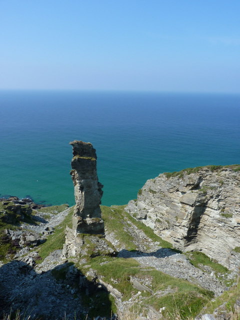
The oldest and largest of the Tintagel coastal slate quarries, worked from the end of the fifteenth century into the twentieth, and left with a 25-metre pinnacle of slate standing in the middle of it because the stone in it was not good enough to take.
History
Slate was cut from the cliffs west of Treknow from about the end of the fifteenth century, which makes Lanterdan the oldest of the Tintagel coastal quarries as well as the largest. At least seven separate quarries were cut into the cliff here, their boundaries now hard to tell apart from those of Caroline and West quarries next door. In 1883 the whole place employed one man, Thomas Sweet; the 1907 Ordnance Survey map still shows it in use. Waste went into the sea at first, and as the working moved inland tramways carried it to the cliff edge to be tipped; later the earlier workings were backfilled, burying some of the older buildings. The quarry never reached the shoreline, because a fault along its base brought up the volcanic lava of the Trambley Cove Formation, which was no use to the quarrymen. What everyone remembers is the pinnacle: a tower of slate about 25 metres high left standing in the middle of the workings because its stone was too poor for roofing. Shorter ones were left for the same reason in West Quarry, and locally such lumps of inferior slate were called scullocks.
Geology
Upper Devonian and Lower Carboniferous slates of an olive-green or blue-black colour, worked mostly for roofing with the rubble used as building material. A fault along the base of the quarry, the Trambley Cove Formation, is volcanic lava. The quarry carries brachiopod fossils and the rare mineral monazite, which holds rare-earth metals.
Workings
The quarry covers about 200 m of coastline, runs up to 80 m inland and stands around 30 m high, without reaching the water's edge, so that it resembles the inland workings at Prince of Wales and Bowithick rather than the sea-cliff quarries either side of it. Horses and ponies powered whim pulleys that lifted slate up and down the quarry walls.
Closure
Working ran on into the early twentieth century; the quarry is shown still in use on the 1907 Ordnance Survey map.
What remains
Disused and in the care of the National Trust, clearly visible from the South West Coast Path and reachable over the rocks from Trebarwith Strand and Hole beaches.
More ruined buildings than any other of the Tintagel coastal quarries: mostly temporary shelters and tool sheds, some probably shelters for the horses that worked the whim pulleys, and four part-buried splitting cabins swallowed by backfill as the working moved inland. Later use by children, anglers and campers has made the original purpose of several of them hard to establish.
Related mines
- Bagalow Quarry — A neighbouring quarry on the same coast.
- Dria Quarry — Another of the nine quarries on the Tintagel to Trebarwith coast.
- Lambshouse and Gull Point Quarry — Another of the coastal slate quarries on this stretch.
- Long Grass Quarry — Another of the coastal quarries on the same stretch; Long Grass was the last of them at work.
- Prince of Wales Quarry — An inland Tintagel slate quarry the sources compare Lanterdan with, both working back from the cliff rather than down to the sea.
- Tintagel Slate Quarries — Lanterdan is the largest of the coastal slate quarries covered by the Tintagel record.
Nearby mines
- Tintagel Slate Quarries — 0.0 km W
- Bowithick Quarry — 0.2 km S
- Dria Quarry — 0.6 km S
- Bagalow Quarry — 0.9 km S
- Lambshouse and Gull Point Quarry — 1.0 km N
Straight-line distance, within 15 km. Show on the map.
Recorded claims
Individual factual claims, each attached to the source(s) that support it below. Where sources disagree, both are kept.
- Lanterdan is the oldest and largest of the Tintagel coastal slate quarries, worked from the end of the fifteenth century until the early twentieth. 1
- A pinnacle of slate about 25 m high was left standing in the quarry because the stone in it was not good enough for roofing; locally such inferior slate was called scullocks. 1,2,3
- The workings cover about 200 m of coastline, extend up to 80 m inland and reach about 30 m in height, without reaching the water's edge. 1
- In 1883 the quarry employed a single worker, Thomas Sweet, and the 1907 Ordnance Survey map still shows it in use. 1
- The workings never reached the shoreline because a fault along the base of the quarry, the Trambley Cove Formation, is volcanic lava that was no use to the quarrymen. 3
- The quarry is of geological interest for its brachiopod fossils and for monazite, a rare mineral containing rare-earth metals. 3
- Lanterdan has more ruined buildings than any other of the Tintagel coastal quarries, among them four part-buried splitting cabins and probable shelters for the horses that worked the whim pulleys. 1
Photographs & further reading
The quarry's age, extent and pinnacle, the single worker recorded in 1883 and what the 1990 archaeological survey made of its ruined buildings.
View sourceWhy the pinnacle was left, what scullocks were, and the fault of volcanic lava that stopped the workings short of the sea.
View sourceSources
- (secondary) Lanterdan Quarry — Wikipedia
- (secondary) Tintagel Slate Quarries, Cornwall — Cornwall Calling
- (secondary) Lanterdan Quarry — iWalk Cornwall
Record created: 24 September 2026 · Last researched: 24 September 2026