 MineArchive
East Harptree Lead Works
| Also known as | Smitham Chimney |
|---|---|
| Location | Smitham Hill, East Harptree Woods, just outside East Harptree, in the parish of Priddy, Somerset — 51.2879, -2.6395 (exact) |
| Commodity | Lead |
| Type | Metal |
| Worked | 1867–1875 |
| Maximum depth | Unknown. |
Overview
A short-lived Victorian venture on Smitham Hill above East Harptree, set up by Cornish engineers in 1867 to re-smelt the old Mendip slag; it closed in 1875 and left Smitham Chimney, the last lead-smelting chimney standing on Mendip.
History
The Harptree area was an old lead and zinc district, with lead ore taken from veins in the Carboniferous Limestone around Gibbets Brow and Lamb Leer and manganese and zinc from the Dolomitic Conglomerate around Harptree Combe. In 1867 a group of Cornish engineers came to revive the worked-out mines and re-smelt the old slag heaps, forming the East Harptree Lead Works Company and building ore-dressing and smelting works on Smitham Hill, where much of the district's ore was processed. By 1870 the works were producing 1,000 tons a year.
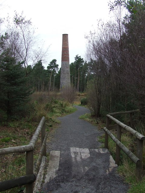
The company was largely unsuccessful and closed in 1875. In 1876 all its buildings were pulled down except the chimney. Smitham Chimney fell into disrepair; Somerset County Council proposed to demolish it in 1973, but it was saved and restored by the Mendip Society in the early 1970s, and is listed at Grade II. Lead in the ground around the site now supports the rare lead moss Ditrichum plumbicola.
Geology
Old lead slag and waste from earlier Mendip working; lead veins in the Carboniferous Limestone around Gibbets Brow and Lamb Leer, with manganese and zinc in the Dolomitic Conglomerate of Harptree Combe.
Workings
Ore-dressing floors, a smelting furnace with flues and its chimney, and reservoirs for the dressing water.
Closure
Closed in 1875; all buildings except the chimney were demolished in 1876.
What remains
Smitham Chimney stands, restored and listed at Grade II, in East Harptree Woods; the earthworks of the buildings, furnace, flues and reservoirs remain.
Smitham Chimney, a circular chimney with two kinds of red brick in its upper part, and earthworks of the works, furnace, flues and reservoirs.
Redevelopment
Woodland.
Related mines
- Chewton Mineries — Mendip lead works that re-treated old slag and waste in the nineteenth century.
- Priddy (St Cuthbert's) Lead Works — Mendip lead works that re-treated old slag and waste in the nineteenth century.
Nearby mines
- Chewton Mineries — 1.7 miles (2.8 km) S
- Priddy (St Cuthbert's) Lead Works — 2.2 miles (3.5 km) S
- Blackmoor Rake — 3.0 miles (4.9 km) W
- Ubley Rake — 3.2 miles (5.1 km) W
- Grebe Swallet Mine — 3.2 miles (5.2 km) W
Straight-line distance, within 9 miles (15 km). Show on the map.
Recorded claims
Individual factual claims, each attached to the source(s) that support it below. Where sources disagree, both are kept.
- The East Harptree Lead Works Company was set up in 1867 by Cornish engineers to rework old mines and re-smelt the slag heaps. 1,2
- Ore-dressing and smelting works were built on Smitham Hill in 1867, and Smitham Chimney dates from then. 2,3
- By 1870 the works were producing 1,000 tons a year. 2
- The venture closed in 1875 and all its buildings except the chimney were demolished in 1876. 1
- Smitham Chimney, restored by the Mendip Society in the early 1970s and listed at Grade II, is the last old lead-smelting chimney standing on Mendip. 1,2,3
Sources
- (primary) History of lead mining — British Geological Survey (Foundations of the Mendips)
- (secondary) Smitham Chimney, East Harptree — Wikipedia
- (secondary) Harptree and Smitham Hill — British Geological Survey (Foundations of the Mendips)
Record created: 19 October 2026 · Last researched: 19 October 2026