 MineArchive
Cwm Bychan Copper Mine
| Also known as | Nantmor Mine |
|---|---|
| Location | Cwm Bychan, above Nantmor near the Aberglaslyn Pass, south of Beddgelert, Gwynedd — 53.0043, -4.0841 (approximate) |
| Commodity | Copper |
| Type | Metal |
| Worked | from 1720 |
| Maximum depth | Unknown. |
Overview
A copper mine in Cwm Bychan above Nantmor, recorded from 1720 and revived in 1925 by the Nantmor Copper Co, whose aerial ropeway carried ore 1.4 km down to a mill by the Welsh Highland Railway; its steel pylons still stand.
History
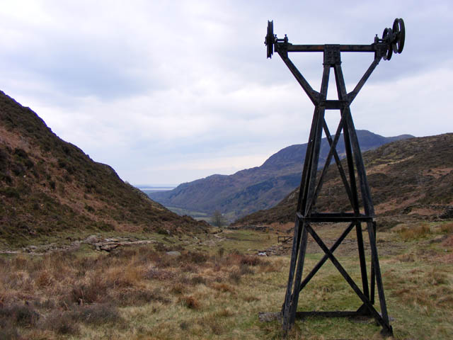
Copper has been worked in Cwm Bychan, above Nantmor, since at least 1720, and by the early eighteenth century a scatter of levels and trials had been opened on four lodes near the head of the valley; the Ordnance Survey map of 1889 marks old levels and trial levels there. The most prominent remains belong to a late revival begun in 1925 by the Nantmor Copper Co., which set out to win the ore left in the spoil tips of the nineteenth-century workings.
The company's equipment was modern for its day: an aerial ropeway about 4,500 feet long on eleven pylons, dropping 168 metres, carried buckets of ore from a terminal station near the lodes down to a processing plant with crushing tanks and buddles by the Welsh Highland Railway, just outside a tunnel mouth. The ropeway had a short life; its filled buckets tended to hit the ground, and the whole enterprise was eventually abandoned. The National Trust has since consolidated the site.
Geology
Four copper lodes near the head of Cwm Bychan.
Workings
Old levels and trials, including an adit about 50 metres long; in the 1920s an aerial ropeway of about 1.4 km on eleven pylons to a mill with crushing tanks, buddles and ore platforms.
Closure
The 1920s working was short-lived and was abandoned after trouble with the ropeway.
What remains
Four steel pylons near the top station, the terminal wheel, lengths of cable and the concrete foundations of the mill survive; the National Trust has consolidated the site.
Ropeway pylons and terminal station, cable, a large mineral-stained spoil tip with huts, and the mill's concrete platforms, buddles and tanks beside the Welsh Highland Railway.
Redevelopment
Unknown.
Nearby mines
- Fron-Boeth and Pant Mawr Quarry — 0.6 miles (0.9 km) S
- Sygun Copper Mine — 0.8 miles (1.3 km) N
- Gorseddau Quarry — 2.2 miles (3.6 km) SW
- Prince of Wales Quarry — 3.3 miles (5.3 km) W
- Croesor Quarry — 3.6 miles (5.7 km) E
Straight-line distance, within 9 miles (15 km). Show on the map.
What's uncertain
Points where sources disagree or the record could not be settled; both accounts are kept. All open questions in the archive.
- The aerial ropeway was built in 1927. (uncertain) 4
Recorded claims
Individual factual claims, each attached to the source(s) that support it below. Where sources disagree, both are kept.
- Mining has been recorded at Cwm Bychan since 1720. 1,2
- The modern working was started in 1925 by the Nantmor Copper Co. 3
- The aerial ropeway was built in 1927. (uncertain) 4
- The aerial ropeway, about 1.4 km long on eleven pylons, carried ore from the lodes at the head of Cwm Bychan to a processing plant near Nantmor beside the Welsh Highland Railway. 1,2,3
- The ropeway was built to work the ore left in the spoil tips of the nineteenth-century mine, and had a short life. 5
- The ropeway's buckets tended to hit the ground, and the enterprise was abandoned. 5,4
- A deposited plan covers the Cwm Bychan or Nantmor Mine at SH 602 472. 6
Sources
- (secondary) Cwm Bychan Copper Mine and Aerial Ropeway, Beddgelert (NPRN 33771) — Coflein (RCAHMW)
- (secondary) Aberglaslyn Cwm Bychan Area of Copper Mining (NPRN 413267) — Coflein (RCAHMW)
- (secondary) Beddgelert and its railways (Section 22) — Jaggers Heritage
- (observational) Cwm Bychan Aerial Ropeway Pylons — Komoot
- (secondary) Aberglaslyn Cwm Bychan Aerial Cableway and Processing Plant (NPRN 413266) — Coflein (RCAHMW)
- (primary) BGS mine plan: Cwm Bychan or Nantmor Mine (NGR SH602472) — British Geological Survey / Mining Remediation Authority
Record created: 19 October 2026 · Last researched: 19 October 2026