 MineArchive
Carnarvon Colliery
| Also known as | Baccas Colliery, Caernarfon Coal Pit |
|---|---|
| Location | Bynea, near the Loughor estuary, Llanelli, Carmarthenshire — 51.6665, -4.0995 (exact) |
| Commodity | Coal |
| Type | Coal |
| Worked | 1775–1927 |
| Maximum depth | Over 190 ft (58 m), to the Penbryn Vein |
| Operators | Llangennech Colliery Co. (1838–?) |
Overview
An old colliery at Bynea on the Loughor estuary, begun in the late eighteenth century and worked on and off by different owners until 1927; an explosion in 1868 killed four with afterdamp, and its brick chimney still stands.
History
Carnarvon Colliery lay near the Loughor estuary at Bynea, east of Llanelli. Coflein dates the coal pit to 1775; Welsh Coal Mines has two shafts sunk in the 1790s with little success, first 120 feet to the Carnarvon Old Vein, then 150 feet to the Carnarvon New Vein, and finally to the Penbryn Vein at over 190 feet. In 1838 the mine was bought by the Llangennech Colliery Company, which worked it for some years.
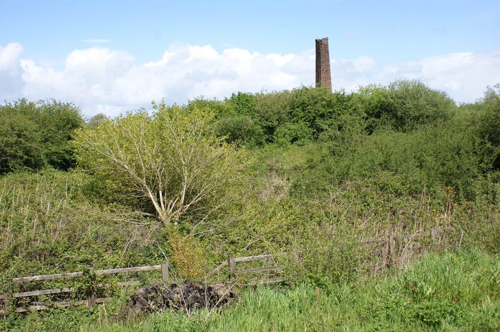
On 12 May 1868 an explosion filled the workings with afterdamp, which killed four miners: David Bowen, 64, John Hopkins, 34, Thomas Phillips, 27, and Thomas Richard, 20. The colliery, sometimes called Baccas, had a chequered life, worked intermittently by a succession of owners, and finally closed in 1927. An abandonment plan groups it with Tirbach and the Caedu pits in the Rosy, Fiery, Golden and Bushy seams of the Llanelli district. The site has since been cleared apart from a tall brick chimney, seen from the A484 above a partly overgrown spoil heap.
Geology
South Wales Coalfield, Llanelli district: the Carnarvon Old and New Veins and the Penbryn Vein; plans record the Rosy, Fiery, Golden and Bushy seams.
Workings
Two shafts, to the Carnarvon Old Vein at 120 ft, the Carnarvon New Vein at 150 ft and the Penbryn Vein at over 190 ft.
Closure
Worked intermittently by different owners until it closed in 1927.
What remains
The site is cleared except for a brick chimney; the spoil heap is partly overgrown.
A tall brick chimney, the only surviving surface building, and a spoil heap.
Redevelopment
Unknown.
Nearby mines
- Glynea Colliery — 0.4 miles (0.7 km) N
- Genwen Colliery — 0.7 miles (1.1 km) N
- Pencoed Colliery — 0.9 miles (1.5 km) N
- Broad Oak Colliery, Loughor — 1.3 miles (2.1 km) E, Swansea
- Glanmwrwg Colliery — 1.6 miles (2.6 km) NW
Straight-line distance, within 9 miles (15 km). Show on the map.
What's uncertain
Points where sources disagree or the record could not be settled; both accounts are kept. All open questions in the archive.
- The Caernarfon coal pit dates from 1775. (disputed) 1
- Two shafts were sunk in the 1790s, to the Carnarvon Old Vein at 120 ft, the Carnarvon New Vein at 150 ft and the Penbryn Vein at over 190 ft. (disputed) 2
Recorded claims
Individual factual claims, each attached to the source(s) that support it below. Where sources disagree, both are kept.
- The Caernarfon coal pit dates from 1775. (disputed) 1
- Two shafts were sunk in the 1790s, to the Carnarvon Old Vein at 120 ft, the Carnarvon New Vein at 150 ft and the Penbryn Vein at over 190 ft. (disputed) 2
- In 1838 the mine was bought by the Llangennech Colliery Company. 2
- On 12 May 1868 four miners died of afterdamp after an explosion. 2
- Worked on and off by different people, it finally closed in 1927. 2,3
- The site is destroyed apart from a brick stack; the spoil heap is partially overgrown. 1,3
- An abandonment plan covers Carnarvon, Tirbach and Caedu Nos. 1 and 2 in the Rosy, Fiery, Golden and Bushy seams. 4
Sources
- (secondary) Caernarfon Coal Pit (NPRN 33387) — Coflein (RCAHMW)
- (secondary) Carnarvon Colliery, Bynea — Welsh Coal Mines
- (observational) Chimney of the former Carnarvon Colliery — Geograph
- (primary) BGS mine plan: Carnarvon, Tirbach, Caedu No 1, Caedu No 2, unnamed pits (Rosy, Fiery, Golden, Bushy seams) — British Geological Survey / Mining Remediation Authority
Record created: 17 October 2026 · Last researched: 17 October 2026