 MineArchive
Caldon Low Quarry
| Also known as | Cauldon Low Quarry, Caldon Quarry |
|---|---|
| Location | Caldon Low, near Cauldon and Waterhouses, Staffordshire Moorlands, Staffordshire — 53.0430, -1.8760 (approximate) |
| Commodity | Limestone |
| Type | Quarry |
| Worked | Before 1776–Still active |
| Maximum depth | An open limestone quarry worked in benches; no shaft depth applies. |
| Operators | London, Midland and Scottish Railway (1923–1934) |
Overview
A limestone quarry high in the Staffordshire Moorlands whose stone fed the Potteries and the lime kilns of the Churnet valley. Limestone had been got here by small concerns for years before the Trent & Mersey Canal Company obtained an Act in 1776 for a branch canal to Froghall with a railway onward to the quarry — the canal could not climb 700 feet in four miles, so a plateway was built instead and opened in 1777. Four successive tramways served the quarry over the next seventy years; the last, a cable-worked line of 1849, ran until 1920. The quarry is still working.
History
Limestone had been quarried at Caldon Low by various small concerns for many years before the canal age reached it. On 13 May 1776 the Trent & Mersey Canal Company obtained an Act for a branch canal from the main line at Etruria to Froghall, with a railway thence to Caldon Low. The original intention was to serve the quarries by canal, but a rise of 700 feet in four miles proved impracticable to overcome by locks, and a railway was chosen as far simpler. The first line opened in 1777. It was replaced three times. The 1783 line aimed at a more gradual rise from Froghall on better-engineered track, running up Harston Wood near the valley bottom and climbing a neck of the wood to emerge in open fields above Whiston; it lasted until 1802, when a further line brought in cast-iron plates with an inner flange to guide the wagons. In January 1847 the North Staffordshire Railway acquired the Trent & Mersey Canal, and in 1849 built a three-foot-six-inch gauge line from Froghall Basin to Caldon Low, worked on the self-acting principle by cables in four sections. That line ran until 1920 — the weighbridge house at Froghall still carries the notice "NSR. This incline will be closed for traffic from the 25th of March 1920". Under the LMS the quarry was worked directly until the end of 1934, raising around 200,000 tons a year in the early LMS period, falling to just over 165,000 tons in 1929 and to 27,000 tons a year by 1953.
Geology
Carboniferous limestone at the south-western edge of the Peak, standing high above the Churnet valley — which is the whole difficulty of the place. The stone was abundant and good, and it sat 700 feet above the nearest navigable water. Every transport scheme built here for a century and a half was an answer to that gradient.
Workings
Open quarrying on the hilltop, with the stone taken down to Froghall by successive tramways: the plateway of 1777, the regraded line of 1783, the flanged-plate line of 1802 and the cable-worked line of 1849. The last was heavily engineered but simple to run, going practically dead straight across country on steadily rising gradients, with all four of its inclines worked by balancing loaded wagons against empty ones — the cable wound round a drum on the site of the first Froghall plane of 1802, the second incline about seventy chains long with its drum at Oldridge above Whiston. At Froghall Basin there were marshalling roads and sidings to the kilns on one flank and a crushing plant on the other.
Closure
The quarry has not closed. What closed was the system that served it: the 1849 cable line shut to traffic on 25 March 1920, and the LMS worked the quarry itself only to the end of 1934. Output fell heavily thereafter — 27,000 tons a year by 1953 against 200,000 in the early 1920s — but the quarry survived and is worked today.
What remains
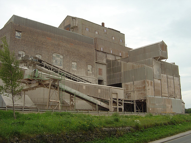
A working quarry with modern crushing plant on site and a rail connection. The stone has a reddish cast that gives the quarry buildings a distinctive colour.
The formations of the successive tramways down to Froghall, including embankments of the 1785 line and the incline routes of 1849, and at Froghall Basin the kilns, the weighbridge house with its 1920 closure notice, and the site of the crushing plant.
Nearby mines
- Brown End Quarry — 0.6 miles (1.0 km) NE
- Thorswood Mines — 2.3 miles (3.7 km) SE
- Bincliff Lead Mines — 4.0 miles (6.4 km) N
- Ecton Copper Mines — 5.5 miles (8.8 km) N
- New Haden Colliery — 5.9 miles (9.6 km) SW
Straight-line distance, within 9 miles (15 km). Show on the map.
Recorded claims
Individual factual claims, each attached to the source(s) that support it below. Where sources disagree, both are kept.
- On 13 May 1776 the Trent & Mersey Canal Company obtained an Act for a branch canal from Etruria to Froghall with a railway thence to Caldon Low. It was originally intended to serve the quarries by canal, but a rise of 700 feet in four miles proved utterly impracticable to overcome by locks, so a railway was chosen as far simpler; the first railway opened in 1777. 1
- The 1783 line aimed at a fairly gradual rise from Froghall on better engineered track and was in use until 1802; the inner flange to the cast-iron strip that guided the wagons did not appear at Froghall until 1802. In 1849 the North Staffordshire Railway built a 3 foot 6 inch gauge line from Froghall Basin to Caldon Low, worked on the self-acting principle by cables in four sections. 1
- The line ran practically dead straight across country on steadily rising gradients, all four inclines worked by balancing the loads, the cable wound round a drum at the site of the first Froghall plane of 1802; the second incline was about 70 chains long with its drum at Oldridge above Whiston. 1
- The weighbridge house at Froghall Basin still stands, bearing the notice "NSR. This incline will be closed for traffic from the 25th of March 1920." 1
- The quarry was worked by the LMS until the end of 1934, and in the early LMS period around 200,000 tons of limestone was quarried annually. This dropped to just over 165,000 tons in 1929 and, by 1953, to 27,000 tons a year. 1
- The Caldon branch of the Trent & Mersey Canal was opened in 1778 to carry limestone quarried at Caldon Low, running from Froghall in the Churnet valley to Etruria in the Potteries. 2
Photographs & further reading
A 1954 paper reconstructing all four tramways between Froghall and the quarry: why a canal was abandoned for a railway in 1776, the route of each successive line, how the 1849 cable inclines were balanced, and the quarry’s output under the LMS.
View sourceSources
- (secondary) The Caldon Low Tramways (LMS Society Occasional Paper No. 6) — Dr J. R. Hollick, via the LMS Society
- (secondary) Caldon Canal — Wikipedia
Record created: 8 September 2026 · Last researched: 8 September 2026