 MineArchive
Brynyrafr Mine
| Also known as | Bryn-yr-Afr Mine, Bryn yr Afr Mine |
|---|---|
| Location | Camdwr valley above Nant-y-moch, about five and a half miles east of Talybont, Ceredigion — 52.4746, -3.8491 (exact) |
| Commodities | Lead, Zinc, Silver |
| Type | Metal |
| Worked | 1879–1912 |
| Maximum depth | 77 fathoms (about 141 m) |
| Operators | Mid-Wales Mines Ltd (owner) — Owner in 1896, when 50 men were employed; John Mitchell's company. |
Brynyrafr was a lead and zinc mine beside the Camdwr stream in the hills east of Talybont, opened in 1879 and worked almost without a break from 1881 to 1912. That made it one of the last successful mines of its district. It returned 4,952 tons of lead ore and 8,116 tons of blende from a shaft 77 fathoms deep. Most of the site now lies under Nant-y-moch reservoir.
Location
Recorded location. The large pin is this mine; the small round markers are the nearest mines on record. Click one for its page. View on full map
History
A group of Liverpool businessmen put up the money to open Brynyrafr in 1879, and a fine lode was soon found. For its first years the mine had no dressing floors of its own and used those of its neighbour, South Cambrian, which had closed in 1881 or 1882; a new floor was added later. By 1884 it was a successful mine.
Ore was returned every year from 1881 to 1912 except 1909. Over those 31 years the mine sold 4,952 tons of lead ore and 8,116 tons of blende, about five tons of blende to every three of galena, and the share of blende rose as the workings went deeper. The best year for lead was 1889, with 359 tons. In 1896, when the mine belonged to John Mitchell's company, Mid-Wales Mines Ltd, 32 men worked underground and 18 at the surface.
By the end there were no reserves of any size above the bottom level, and going deeper meant sinking the shaft and paying more to raise the ore, which was drawn by engine at a mine miles from any railway. Work stopped in 1912. The valley was later dammed, and the mine went under the water.
Geology
The mine lies in the Van formation. The lode carries blende and galena with, in places, a good deal of marcasite and iron pyrites. The ore body lengthens downward, from about 65 fathoms stoped at the adit to 200 fathoms of ore at the 67-fathom level, and east of the shaft it is mainly blende. About 94 fathoms west of the shaft a cross-fault heaves the lode some 5 fathoms to the north. Beds of grit met in driving east almost pinched the lode out, and the shaft seems to have been sunk near the crest of an anticline.
Geological setting: Veins and Lodes (well documented example)
Workings
The mine was worked from a pumping and drawing shaft sunk on the lode to 77 fathoms, with levels at 13, 24, 35, 45, 57, 67 and 77 fathoms. The pump was driven by a large waterwheel near the river through a line of rods about 400 yards long. A shallow adit cross-cut, entering the hill 150 yards south of the shaft, drained the ground to 15 fathoms. The bottom level was driven 105 fathoms each way from the shaft, nearly all of it in ore. Late in the mine's life a new shaft was sunk about 100 yards to the west, into ground where little had been done.
Closure
Work stopped in 1912. No considerable reserves were left above the 77-fathom level, and deeper working would have meant sinking the shaft and higher costs.
What remains
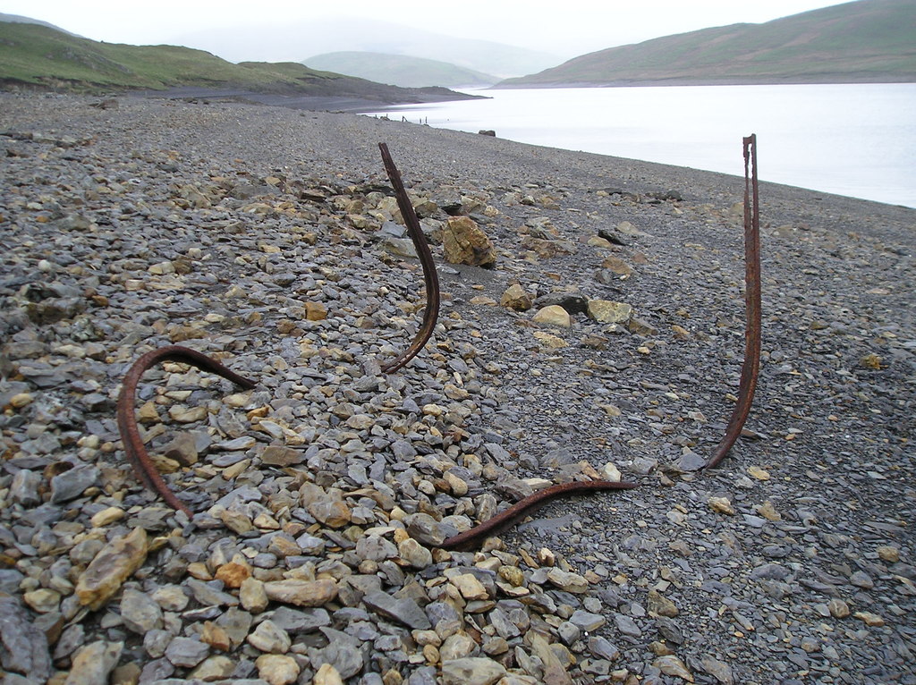
The mine has been almost wholly destroyed: most of its surface features lie under the waters of Nant-y-moch reservoir. Twisted rail from the mine was lying on the reservoir shore in 2010.
Only minor features remain above the water, chiefly the leats that supplied the mine. The long Taylor's leat was tapped for Brynyrafr and a concrete sluice added to control the flow. A breached dam, a reservoir that is now a reed-filled bog and a further leat survive as earthworks in the valley of the Camddwr Bach near by; they may belong either to Brynyrafr or to South Cambrian.
Redevelopment
The valley was flooded to make Nant-y-moch reservoir, which covers most of the mine.
Nearby mines
- Camdwrmawr Mine — 0.4 miles (0.6 km) E
- South Cambrian Mine — 0.5 miles (0.8 km) NW
- Rhyd Fach Mine — 0.6 miles (1.0 km) NW
- Hafan Mine — 0.9 miles (1.5 km) W
- Eaglebrook Mine — 1.0 miles (1.6 km) NW
Straight-line distance, within 9 miles (15 km). Show on the map.
Further reading
The Royal Commission's record of the mine and the leats and reservoirs that survive above the water.
View sourceSources
- (primary) Bryn-yr-Afr Lead Mine (NPRN 268145) — Coflein, Royal Commission on the Ancient and Historical Monuments of Wales
- (primary) Lead and Zinc: The Mining District of North Cardiganshire and West Montgomeryshire (Special Reports on the Mineral Resources of Great Britain, vol. XX), O. T. Jones, 1922 — Memoirs of the Geological Survey
- (primary) Mine plan: Brynyrafr Mine letters, SN78NW 1, 1881-1942 (KP16995) — British Geological Survey
- (observational) Twisted Rail, Nant y Moch Reservoir (photograph, 8 June 2010) — Geograph
Record created: 18 November 2026 · Last researched: 18 November 2026