 MineArchive
Brynarian Mine
| Also known as | Bryn-yr-Arian Mine, Bryn-Arian Mine, Cardigan Bay Consols |
|---|---|
| Location | On the slope east of Tre Taliesin, Llangynfelyn, Ceredigion — 52.5059, -3.9697 (exact) |
| Commodities | Lead, Zinc |
| Type | Metal |
| Worked | 18th century–after 1874 |
| Maximum depth | 30 fathoms below the adit; 50 fathoms at Pensarn |
Brynarian, or Bryn-yr-Arian, was a lead mine on the steep slope east of Tre Taliesin, worked together with the Pensarn mine close by. Its lodes were worked at surface in the eighteenth century. From about 1844 three companies in turn, two from London and one from Leeds, took it up, and the first two lost many thousands of pounds. By 1874 it was called Cardigan Bay Consols. The returns show 294 tons of lead ore.
Location
Recorded location. The large pin is this mine; the small round markers are the nearest mines on record. Click one for its page. View on full map
History
Brynarian was being worked at surface, along a great length and on several lodes, as far back as the 1770s. About 1844 a London company took it up, put in good and powerful machinery and sank on the main lode to 30 fathoms below the adit. The deeper levels gave less lead ore than the shallow workings had, and after a spirited trial of some years the company was wound up with a loss of many thousands of pounds. The mine went by the name of Bryn-Arian, Silver Hill.
About 1859 a party of gentlemen from Leeds tried it again and lost many thousands more. By 1874 the property was Cardigan Bay Consols and in the hands of a third company, from London. Throughout it was held with the Pensarn mine, where an engine shaft was sunk 50 fathoms on rich but short and unreliable bunches of ore.
The returns since 1845 show lead ore in seven years: 294 tons, with 53 tons of blende, and a best year of 95 tons in 1851. This is an old mine, and its whole output may be a good deal more. A further 245 tons returned under the name of Taliesin, in 1854 to 1856 and in 1867, probably came from these workings too.
Geology
The mine is on a group of small lodes crossing the lower beds of the Frongoch formation, here mainly pale greenish, friable mudstones. The veins yielded less lead ore in the deeper levels than near the surface.
Geological setting: Veins and Lodes (historical documentary reference)
Workings
The mine was worked mainly from shafts at about 600 feet above sea level and was partly drained by adits, the lowest at about 240 feet. The main lode was sunk on to 30 fathoms below the adit. The Pensarn mine, about 600 yards to the south-east, has an engine shaft 50 fathoms deep.
Closure
The mine was at work in 1874 under its third company; when that ended is not recorded.
What remains
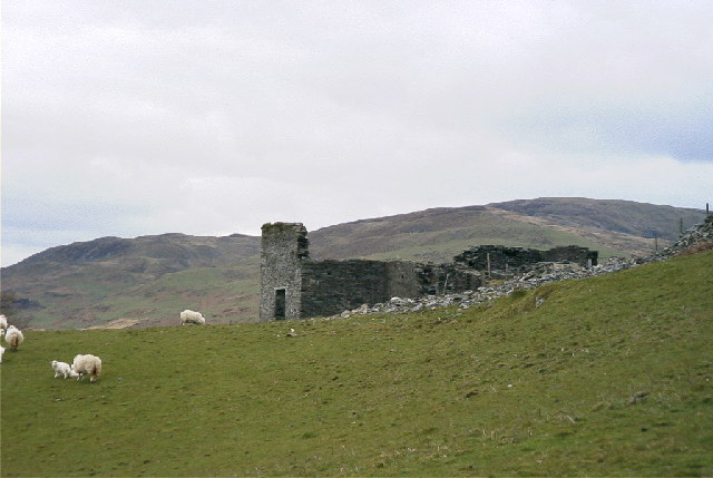
In 2005 the ruined wheelhouse still stood on the hillside: a tall stone end wall with a doorway, and lower walls beside it.
The remains of the wheelhouse and other ruined walls.
Related mines
- Dolclettwr Mine — Both on the Dolyclettwr estate and worked by the same Pwll Roman company from 1853 to 1860.
- Llancynfelyn Mine — Lead ore returned under the name of Taliesin in 1854-56 and 1867 may have come from either mine, more probably from Brynarian.
Nearby mines
- Dolclettwr Mine — 0.3 miles (0.5 km) NW
- Llancynfelyn Mine — 0.8 miles (1.4 km) W
- Erglodd Mine — 1.1 miles (1.7 km) SW
- Penpontbren Mine — 1.1 miles (1.7 km) S
- Loveden Mine — 1.5 miles (2.4 km) N
Straight-line distance, within 9 miles (15 km). Show on the map.
Further reading
The Royal Commission's site record and map position, with aerial photographs of 2007 and 2010.
View sourceA mining agent's account of Cardigan Bay Consols and its three companies, transcribed by the community's history site.
View sourceSources
- (primary) Lead and Zinc: The Mining District of North Cardiganshire and West Montgomeryshire (Special Reports on the Mineral Resources of Great Britain, vol. XX), O. T. Jones, 1922 — Memoirs of the Geological Survey
- (secondary) History of the Cardiganshire Mines, from the Earliest Ages to A.D. 1874, by Absalom Francis (extract for the Llangynfelyn district) — Llangynfelyn community website
- (secondary) Excavations at Erglodd, Llangynfelyn, Ceredigion: prehistoric/Roman lead smelting site and medieval trackway, N. Page, G. Hughes, R. Jones and K. Murphy (Archaeologia Cambrensis 161, 2012) — Cambrian Archaeological Association
- (primary) Bryn-yr-Arian Lead Mine [Disused], SE of Tre'r-Ddol (NPRN 402009) — Coflein, Royal Commission on the Ancient and Historical Monuments of Wales
- (observational) Wheelhouse, Bryn-yr-Arian Mine (Geograph photograph 9664, 2005) — Geograph
Record created: 18 November 2026 · Last researched: 18 November 2026