 MineArchive
Barbush Pits
| Location | Barbush estate, north of Johnstone, Kilbarchan parish, Renfrewshire — 55.8419, -4.5084 (approximate) |
|---|---|
| Commodities | Ironstone, Coal, Oil Shale |
| Type | Ironstone |
| Worked | Early 1850s–1881 |
| Operators | W. S. Dixon (?–1881) — Proprietors of the Govan Ironworks; worked the Barbush ironstone from the early 1850s (Scottish Shale; 1873 list of mines) |
W. S. Dixon's ironstone pits on the Barbush estate north of Johnstone, worked from the early 1850s for the Govan Ironworks, which also raised coal and oil shale and were abandoned in stages between 1874 and 1881.
Location
Approximate location. The large pin is this mine; the small round markers are the nearest mines on record. Click one for its page. View on full map
History
W. S. Dixon, proprietors of the Govan Ironworks in Glasgow, began working ironstone on the Barbush estate, north of Johnstone in the parish of Kilbarchan, in the early 1850s. The pits at work when the first Ordnance Survey was made, about 1858, were named on the map after the neighbouring farms, and none was called Barbush; the precise sites of the Barbush pits and the bounds of the mineral field are unknown. The later pits were numbered. The Bridge of Weir Railway Bill of 1862 included a branch of 19 chains to the lands of Barbush, and Airey's railway map of 1875 showed sidings to Barbush No. 4 and No. 5 pits.
The 1873 list of mines records three Barbush entries under W. S. Dixon, for ironstone, shale and coal, and the mineral statistics list Barbush as a colliery in 1874. In 1866 the workers at the Elderslie and Barbush collieries sent a collection to Paisley Infirmary through Andrew Bennie, manager to William Dixon, and in 1877 contractors were sought to work the ironstone at No. 6 pit. Shaft work was dangerous: in July 1856 a young miner being drawn up in the creel was caught by the signal gear and fell to the bottom.
Sandholes pit was abandoned in 1874, and the Barbush coal pit and the Linwood Clayband ironstone at Nos. 4 and 6 in 1875. The Johnstone Clayband at No. 6, the Tree pit, followed in August 1881, the year of the plan of Barbush Colliery on the lands of Milliken, and working seems to have ended about then. The mineral rights passed to the Clippens Oil Company in 1882, and the Glasgow and South Western Railway resolved in 1889 to abandon the disused Barbush branch.
Geology
Clayband ironstone of the Renfrewshire coalfield: the abandonment plans name the Linwood Clayband and the Johnstone Clayband. Coal and oil shale were raised as well.
Workings
Numbered pits, at least Nos. 4, 5 and 6, and a Sandholes pit. No. 4 was served by a siding from the Bridge of Weir branch east of Houstoun station, whose disused course still showed on the Ordnance Survey of about 1894; No. 6 was also known as the Tree pit.
Closure
Sandholes pit was abandoned in 1874, the coal pit and the ironstone at Nos. 4 and 6 in 1875, and the ironstone and shale at No. 6 in 1881. The Clippens Oil Company acquired the mineral rights in 1882 but is not known to have worked them.
What remains
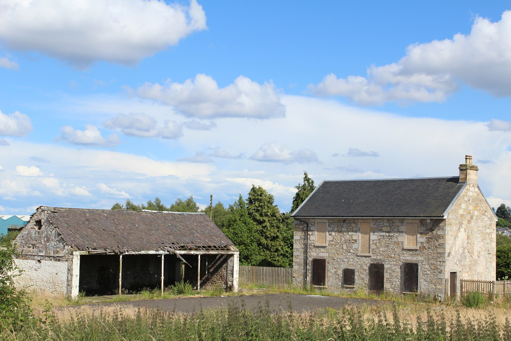
The sites of the pits are uncertain. Barbush Farm survives in part: only the farmhouse and one shed were standing in 2014.
Related mines
- Cleland Colliery — Both were worked by W. S. Dixon of the Govan Ironworks: Cleland for coal from 1862 to 1878, Barbush for ironstone, shale and coal.
Nearby mines
- Clippens Pits — 0.4 miles (0.7 km) NE
- Abercorn Pits — 1.1 miles (1.8 km) NE
- Blackstoun Pits — 1.2 miles (1.9 km) NE
- Blackstone Pits — 2.3 miles (3.8 km) NE
- Walkinshaw Pits — 2.5 miles (4.1 km) NE
Straight-line distance, within 9 miles (15 km). Show on the map.
Further reading
History, maps and newspaper reports of the Barbush ironstone pits.
View sourceThe 1873 list of mines, with the three Barbush entries under W. S. Dixon.
View sourceSources
- (secondary) Barbush pits (Scottish Shale, Museum of the Scottish Shale Oil Industry) — Museum of the Scottish Shale Oil Industry
- (secondary) List of Mines in Scotland 1873, Part 5 (Scottish Mining Website) — Scottish Mining Website
- (primary) BGS / Mining Remediation Authority mine plan 21861748: Barbush Nos. 4 and 6, Linwood Clayband ironstone, abandoned 15 July 1875 — British Geological Survey
- (primary) BGS / Mining Remediation Authority mine plan 21874456: Barbush Nos. 4 and 6 (Tree), Johnstone Clayband ironstone, abandoned 13 August 1881 — British Geological Survey
- (primary) BGS / Mining Remediation Authority mine plan 16080: Barbush Colliery, lands of Milliken, abandoned 1881 — British Geological Survey
Record created: 5 November 2026 · Last researched: 8 November 2026