 MineArchive
Appletree Mine
| Also known as | South Crinnis Mine, Hwel Avalen |
|---|---|
| Location | Appletree Point, between Charlestown and Carlyon Bay, St Austell, Cornwall — 50.3358, -4.7461 (exact) |
| Commodity | Copper |
| Type | Metal |
| Worked | By 1840–1866 |
| Maximum depth | Unknown. |
Overview
A coastal copper mine between Charlestown and Carlyon Bay, also called South Crinnis, bounded by West Crinnis, Great Crinnis, Wheal Polmear and the sea, which sold 16,575 tons of copper ore between 1840 and 1866 from hot, badly ventilated workings and closed in 1866; the ground is now built over.
History
Appletree Mine, or South Crinnis, lay on the cliffs immediately south of West Crinnis, between the eastern beach at Charlestown and Crinnis Beach at Carlyon Bay. Its sett was bounded on the north by West Crinnis, on the east by Great Crinnis, on the west by Wheal Polmear and on the south by the sea. It opened many years after Joshua Rowe's great discovery at Crinnis in 1811, with returns from 1840, and was a cost-book company of 128 shares. The Mining Journal's 1856 directory gives its purser as J. Petherick of St Austell and its captain as Francis Barrett.
In 1855 the mine sold 1,772 tons of copper ore for £13,843 9s 6d and paid £7,680 in dividends, £60 a share. Over its life, from 1840 to 1866, it returned 16,575 tons of copper ore at seven per cent, with 483 tons of pyrite, 234 tons of blende and a ton of 75 per cent lead ore: 6,097 tons of copper ore worth £44,950 between 1849 and 1856, and 10,478 tons worth £59,534 between 1857 and 1866. The workings were poorly ventilated, with temperatures reported at 90 to 100 degrees Fahrenheit, and the men worked stripped to the waist; lung disease and consumption were serious among the workforce. The Mining Journal index for 1860 records an accident at the mine without detail.
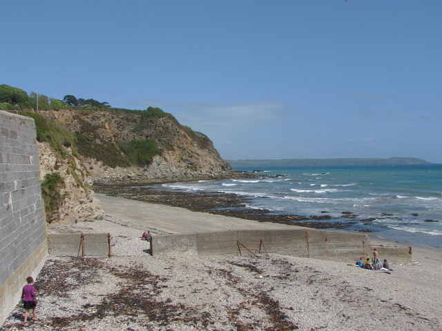
Appletree closed in 1866. The Ordnance Survey of 1888 marked it as a disused copper mine, and one database lists a later working from 1901 to 1910 without detail. The main workings must have been extensive, but the only ones now visible are short levels in the base of the cliff at Appletree Cove, the first bay east of Charlestown's eastern beach, which do not connect with them. The surface has since been built over.
Geology
Copper lodes in the coastal killas of St Austell Bay, the same ground as the Crinnis mines to the east and north, carrying pyrite, blende and a little galena with the copper ore.
Geological setting: Veins and Lodes (historical documentary reference)
Workings
A cost-book copper mine of 128 shares whose main workings, said to have been extensive, ran under the cliff-top between West Crinnis and the sea; short levels driven into the base of the cliff at Appletree Cove are separate from them. The levels were hot and badly ventilated.
Closure
Returns ended in 1866 and the mine closed that year; the 1888 Ordnance Survey marked it disused. A working of 1901 to 1910 is listed by one database without detail.
What remains
The site is built over; short adit mouths remain in the base of the cliff at Appletree Cove.
Short levels in the cliff at Appletree Cove; nothing of the main mine survives at surface.
Redevelopment
The mine's ground is covered by later building.
Related mines
- Great Crinnis Mine — Adjoining setts on the Crinnis copper ground, South Crinnis bounded on the east by Great Crinnis; Lyndon Allen's account maps the workings of the two mines together.
Nearby mines
- West Crinnis Mine — 0.1 miles (0.2 km) N
- Wheal Regent — 0.3 miles (0.4 km) NE
- Cuddra Mine — 0.3 miles (0.5 km) NE
- Great Crinnis Mine — 0.4 miles (0.7 km) E
- Carclaze Pit — 2.0 miles (3.2 km) NW
Straight-line distance, within 9 miles (15 km). Show on the map.
What's uncertain
Points where sources disagree or the record could not be settled; both accounts are kept. All open questions in the archive.
- Worked from 1901 to 1910. (uncertain) 3
Recorded claims
Individual factual claims, each attached to the source(s) that support it below. Where sources disagree, both are kept.
- South Crinnis Mine, in the parish of St Austell, was bounded on the north by West Crinnis, on the south by the sea, on the east by Great Crinnis and on the west by Wheal Polmear. 1
- In 1855 the mine sold 1,772 tons of copper ore for £13,843 9s 6d and paid dividends of £7,680, or £60 on each of its 128 shares. 1
- In 1856 the purser was J. Petherick of St Austell and the captain Francis Barrett. 1
- Between 1840 and 1866 the mine returned 16,575 tons of seven per cent copper ore, 483 tons of pyrite, 234 tons of blende and one ton of 75 per cent lead ore. 2,3
- Appletree sold 6,097 tons of copper ore for £44,950 between 1849 and 1856 and 10,478 tons for £59,534 between 1857 and 1866. 4
- The workings were poorly ventilated, with temperatures of 90 to 100 degrees Fahrenheit, and lung disease and tuberculosis were serious among the workforce. 4
- Appletree closed in 1866. 4
- Worked from 1901 to 1910. (uncertain) 3
- The Mining Journal index for 1860 lists an accident at Appletree Mine. 5
- Short levels are visible in the base of the cliff at Appletree Cove, the first bay east of Charlestown's eastern beach, and do not connect with the main workings. 2
- The Ordnance Survey of 1888 marked Appletree Mine as a disused copper mine. 6
- The mine is now entirely covered by building. 3
Photographs & further reading
A short page on the mine's position, cliff levels and output.
View sourceLyndon Allen's history of the Crinnis mines, with Appletree's sales, working conditions and closure and a map of the Great Crinnis and Appletree workings.
View sourceDatabase entry with the grid reference and references to Collins (1912) and Dines (1956).
View sourceSources
- (secondary) 1856 Mines in Devon and Cornwall — Grace's Guide
- (secondary) Appletree Mine, Cornwall — Cornwall Calling
- (secondary) Appletree (Buddlepit Mine Database) — Buddlepit
- (secondary) Joshua Rowe and the Great Crinnis Copper Mine 1809 (Lyndon Allen, 2026) — Charlestown Tours
- (secondary) 1860 Mining Journal (index) — Grace's Guide
- (secondary) Appletree Mine / Hwel Avalen (Cornish place-names) — Akademi Kernewek
- (observational) Appletree Point (photograph, 2011) — Geograph
Record created: 18 October 2026 · Last researched: 21 October 2026