 MineArchive
Westwood No. 12 and 13 Pits
| Also known as | Westwood No. 12 Pit, Westwood No. 13 Pit |
|---|---|
| Location | Westwood, near West Calder, West Lothian — 55.8577, -3.5833 (approximate) |
| Commodity | Oil Shale |
| Type | Mineral |
| Worked | By 1870–1887 |
| Maximum depth | 203 feet (No. 13 shaft) |
| Operators | Young's Paraffin Light and Mineral Oil Company — Owners of both pits (Scottish Shale) |
Two Young's oil company shale pits near West Calder, worked together for the Addiewell works from about 1870 until 1887; No. 12 now lies under the Five Sisters bing.
Location
Approximate location. The large pin is this mine; the small round markers are the nearest mines on record. Click one for its page. View on full map
History
Westwood Nos. 12 and 13 were two Fells Shale pits of Young's Paraffin Light and Mineral Oil Company, worked together near the Breich Water north-east of West Calder for the Addiewell Chemical Works. Both were at work by 1870 and carried on into the 1880s. No. 12 was a vertical shaft 144 feet deep and No. 13 one of 203 feet, and both were served by a branch of the Addiewell and Polbeth railway that crossed the Breich Water on a viaduct. Their workings seem to have been linked to Fells Shale workings beneath Tenantsmarch, and through them to the Addiewell and Polbeth pits.
The end came in March 1887, and it came quickly. The men at No. 12 were told on a Saturday morning to lift their graith that afternoon, and over a hundred were thrown idle. The West Calder Miners' Association met the following Monday and resolved to find room in other pits for No. 12's old hands where it could, and to help as many as possible move to other districts for work. The workings of both pits in the Thick Shale were abandoned that year.
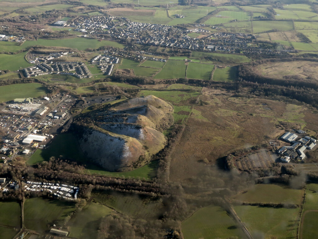
The site of No. 12 now lies buried beneath the southernmost heap of the Five Sisters, the bing of the later Westwood crude oil works. The site of No. 13 is a storage yard.
Geology
The Fells Shale of the West Calder district.
Workings
Two vertical shafts, No. 12 144 feet (24 fathoms) deep and No. 13 203 feet (34 fathoms), served by a railway branch with a viaduct over the Breich Water; workings probably linked to those beneath Tenantsmarch.
Closure
No. 12 was closed in March 1887, putting over a hundred men out of work; the workings of both pits were abandoned in 1887.
What remains
No. 12 lies beneath the Five Sisters bing; the site of No. 13 is the storage yard of a concrete block plant.
None. The Ordnance Survey of about 1897 showed waste bings and a disused shaft at No. 13.
Redevelopment
No. 12 buried by the Westwood bing; No. 13 an industrial storage yard.
Nearby mines
- Westwood No. 1 and 2 Pits — 0.3 miles (0.4 km) N
- Westwood No. 30 Pit — 0.4 miles (0.7 km) NE
- Mid Breich No. 4 Pit — 0.5 miles (0.8 km) NW
- Easter Breich No. 1 and 2 Pits — 0.5 miles (0.9 km) N
- Polbeth No. 7, 7½ and 10 Pits — 0.6 miles (1.0 km) SE
Straight-line distance, within 9 miles (15 km). Show on the map.
Further reading
The Museum of the Scottish Shale Oil Industry's page for No. 12: shaft, railway, workings and the 1887 closure.
View sourceThe Museum of the Scottish Shale Oil Industry's page for No. 13: shaft and site.
View sourceThe national catalogue entry for the joint 1887 abandonment plan.
View sourceSources
- (secondary) Westwood No.12 pit (Scottish Shale) — Scottish Shale
- (secondary) Westwood No.13 pit (Scottish Shale) — Scottish Shale
- (primary) BGS mine plans: Westwood No. 12 and 13, Thick Shale, abandoned 1887 (2130) — British Geological Survey
- (observational) Five Sisters Bing from the air (Geograph) — Geograph
Record created: 20 November 2026 · Last researched: 20 November 2026