 MineArchive
Tunshill Colliery
| Location | Tunshill, near Milnrow, Rochdale, Greater Manchester — 53.6158, -2.0869 (approximate) |
|---|---|
| Commodity | Coal |
| Type | Coal |
| Worked | 1861 to 1864 (sinking)–By 1895 |
| Maximum depth | Unknown. |
| Operators | Richard and William Stott (1861–?), Platt Brothers and Co. Ltd (1881–1895) |
Overview
A colliery at Tunshill, on the Pennine edge above Milnrow, sunk between 1861 and 1864 by Richard and William Stott to work the Lower Mountain Mine and joined by tramway to Butterworth Hall. Three men drowned there in 1867; Platt Brothers reopened it in the 1880s.
History
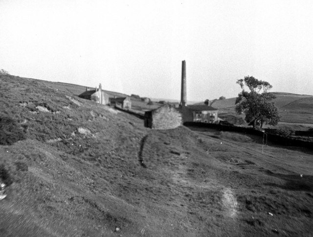
Tunshill Colliery was sunk between 1861 and 1864 by Richard and William Stott, who sank Butterworth Hall Colliery at Milnrow in the same years. It worked the Lower Mountain Mine, and for part of its life a tramway about 1.5 km long joined it to Butterworth Hall. In 1867 three men were drowned in the colliery when underground waters, the same that feed Butterworth Hall Brook, broke through old workings. Abandonment plans of workings in the Mountain and Three Quarters seams are dated 1873. The Stotts worked the colliery until the late 1870s, when it appears to have closed.
Platt Brothers and Company reopened Tunshill between 1881 and 1884. It was inundated on 27 May 1887; it appears to have been recovered, but from 1895 until 1905 it was listed as discontinued. Tunshill was a colliery village, and by 1950 it was largely derelict, the colliery having closed well before the Second World War. The M62 motorway was driven through the area in the 1970s.
Geology
The Lower Mountain Mine; abandonment plans also record workings in the Three Quarters seam.
Workings
Shafts at Tunshill working the Lower Mountain Mine, joined for part of the colliery's life to Butterworth Hall Colliery by a tramway about 1.5 km long.
Closure
Closed in the late 1870s, reopened by Platt Brothers in 1881-84, inundated on 27 May 1887, and listed as discontinued from 1895 to 1905.
What remains
The colliery village was largely derelict by 1950 and the M62 motorway now crosses the area. A capped shaft on Dick Hill nearby is thought to have belonged to the colliery.
The former King's Arms public house of the colliery village survives as a dwelling; a capped shaft on Dick Hill may belong to the colliery.
Redevelopment
The M62 motorway, built through Tunshill in the 1970s.
Nearby mines
- Jubilee Colliery — 1.4 miles (2.3 km) S
- Stockfield Colliery — 5.7 miles (9.1 km) SW
- Chamber Colliery — 5.8 miles (9.3 km) S
- Oak Colliery, Hollinwood — 6.6 miles (10.6 km) S
- Fairbottom Colliery — 7.0 miles (11.3 km) S
Straight-line distance, within 9 miles (15 km). Show on the map.
What's uncertain
Points where sources disagree or the record could not be settled; both accounts are kept. All open questions in the archive.
- A capped shaft on Dick Hill was probably part of Tunshill Colliery. (uncertain) 5
Recorded claims
Individual factual claims, each attached to the source(s) that support it below. Where sources disagree, both are kept.
- Sunk between 1861 and 1864 by Richard and William Stott to work the Lower Mountain Mine. 1
- Three men were drowned in 1867 when underground waters broke through old mine workings. 2
- Abandonment plans of the Mountain and Three Quarters seams are dated 1873. 3
- Reopened by Platt Brothers and Company between 1881 and 1884. 1
- Inundated on 27 May 1887, apparently recovered, and listed as discontinued from 1895 to 1905. 1
- The colliery village of Tunshill was largely derelict by 1950, the colliery having closed well before the Second World War. 4
- A capped shaft on Dick Hill was probably part of Tunshill Colliery. (uncertain) 5
- The M62 motorway was built through Tunshill in the 1970s. 6
Photographs & further reading
The Northern Mine Research Society's page on the colliery, its sinking by the Stotts and its reopening by Platt Brothers.
View sourceSources
- (secondary) Tunshill Colliery (1862-1895) — Northern Mine Research Society
- (secondary) Butterworth Hall Brook — Wikipedia
- (primary) BGS mine plan: Tunshill, Mountain seam (abandoned 1873) — British Geological Survey / Mining Remediation Authority
- (observational) Tunshill Village, near Milnrow, Lancashire (Geograph 306474) — Geograph
- (observational) Capped mine shaft, Dick Hill (Geograph 7941624) — Geograph
- (secondary) Tunshill — Wikipedia
Record created: 17 October 2026 · Last researched: 17 October 2026