 MineArchive
South Pelaw Colliery
| Location | South Pelaw, Chester-le-Street, County Durham — 54.8652, -1.5894 (approximate) |
|---|---|
| Commodity | Coal |
| Type | Coal |
| Worked | 1860 (first shaft)–3 January 1964 |
| Maximum depth | About 623 feet (Busty seam, 1890 section) |
| Operators | Perkins & Co. (1860–?), E. M. Perkins & Partners (?–1886), South Pelaw Coal Co. Ltd. (1890–1947), National Coal Board (1947–1964) |
Overview
A colliery on the northern edge of Chester-le-Street, first worked by the Perkins family from 1860 and re-sunk to the Busty seam in 1890, which closed on 3 January 1964.
History
South Pelaw Colliery lay at South Pelaw, immediately north of Chester-le-Street and about six miles north-north-west of Durham. Boring was going on from the surface on the Low Flatts estate in the township of Harraton as early as 1769. The Perkins family began working here in 1860 with a shaft of 65 fathoms, and the colliery was listed under Perkins & Co. in the 1860s and E. M. Perkins & Partners in the 1880s. Its Low Main and Hutton seams were worked out and abandoned at the end of 1886.
The royalties were re-let in the lower seams in 1890, and the colliery was restarted and sunk from the surface to the Busty seam in 1890-91 for Thomas Gilchrist, leaving the upper seams unworked. The South Pelaw Coal Company worked it from then until nationalisation. Employment grew from 397 in 1894 to a peak of 906 in 1925. The coal went for gas and manufacturing, later for coking and household use, and the colliery was linked by a steep branch from South Pelaw Junction, crossing Pelton Lane on the level. Thomas Armstrong managed it in the 1880s, Edward Watson around 1900 and George A. Gilchrist in the 1910s.
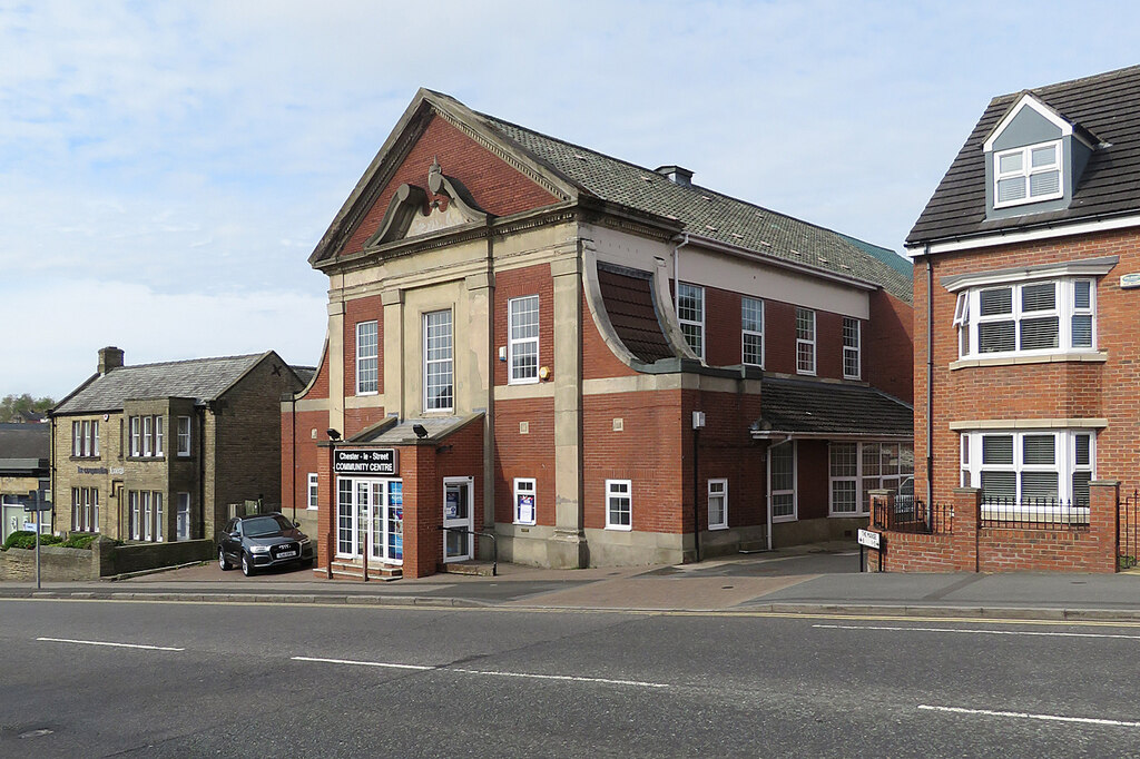
The South Pelaw Colliery Miners' Welfare Hall opened on 30 November 1929, and pit-head baths followed in September 1940, opened by H. Kellett, the colliery's managing director. The National Coal Board took over in 1947, when 732 men raised 150,000 tons. The colliery closed on 3 January 1964 with 377 men, and the welfare hall became a community centre.
Geology
Durham Coal Measures under about 60 feet of clay and gravel. The 1890 section passed the Five Quarter at about 92 feet, the High Main at 186, the Maudlin at 270, the Low Main at 322, the Hutton at 374 and the Harvey at 585, and reached the Busty, 4 feet 7 inches thick, at about 623 feet. The colliery later worked the Busty, Harvey, Maudlin, Five Quarter and Low Main, with some fireclay.
Workings
A single-shaft colliery. The first shaft of 1860 was 65 fathoms deep; the 1890-91 sinking took the colliery to the Busty. Rail traffic left by a steeply graded connection to exchange sidings at South Pelaw Junction, crossing Pelton Lane on the level.
Closure
The colliery closed on 3 January 1964 with 377 men, down from 588 in 1960. The abandonment plans of the Top and Bottom Busty are dated 4 September 1964.
What remains
The colliery's Miners' Welfare Hall on Newcastle Road is now Chester-le-Street Community Centre. The old railway line is part of the Coast to Coast cycle path.
Redevelopment
Unknown.
Nearby mines
- Pelton Colliery — 0.8 miles (1.2 km) SW
- Urpeth Colliery — 1.8 miles (2.9 km) NW
- Handen Hold Colliery — 1.9 miles (3.0 km) W
- Harraton Colliery — 2.0 miles (3.1 km) NE, Tyne and Wear
- Kibblesworth Colliery — 2.7 miles (4.3 km) NW
Straight-line distance, within 9 miles (15 km). Show on the map.
What's uncertain
Points where sources disagree or the record could not be settled; both accounts are kept. All open questions in the archive.
- The colliery employed 353 men in 1896, peaked at 883 in 1930 and had 377 at closure in 1964. (uncertain) 3
Recorded claims
Individual factual claims, each attached to the source(s) that support it below. Where sources disagree, both are kept.
- Boring from the surface was in progress on the Low Flatts estate at South Pelaw, in the township of Harraton, in 1769. 1
- The Perkins family began operations in 1860 with a 65-fathom shaft; a new sinking to the Busty was made in 1890-91 for Thomas Gilchrist. 2
- South Pelaw Colliery opened in 1890 and was closed on 3 January 1964. 1,3
- The Low Main and Hutton seams were abandoned on 31 December 1886 through exhaustion, and the royalties were re-let in the lower seams in 1890. 4
- The 1890 sinking reached the Busty seam, 4 feet 7 inches thick, at 623 feet 4 inches. 5
- The owners were Perkins & Co. in the 1860s, E. M. Perkins & Partners in the 1880s, the South Pelaw Coal Co. Ltd. from the 1890s and the National Coal Board from 1947. 2,3
- Employment was 397 in 1894, 906 in 1925 and 377 in 1964. 1
- The colliery employed 353 men in 1896, peaked at 883 in 1930 and had 377 at closure in 1964. (uncertain) 3
- The South Pelaw Colliery Miners' Welfare Hall opened on 30 November 1929 and became a community centre after the pit closed in 1964. 2,6
- Pit-head baths opened in September 1940, opened by H. Kellett, managing director of South Pelaw Colliery. 2
- Thomas Armstrong was manager from 1882 to 1890, Edward Watson from 1896 to 1900 and George A. Gilchrist in 1910 and 1915. 7
- Plans of the Top and Bottom Busty seams at South Pelaw record their abandonment on 4 September 1964. 8
Photographs & further reading
Owners, output and employment from 1860 to 1964, seams worked, the 1890 shaft section and the names of those killed.
View sourceThe group's summary of South Pelaw Colliery from its 2017 colliery booklets, with the welfare hall and pit-head baths.
View sourceA railway history page on the colliery and its steep connection to South Pelaw Junction, with a 1947 layout plan.
View sourceSources
- (primary) Durham Mining Museum - South Pelaw Colliery — Durham Mining Museum
- (secondary) Collieries Project - Chester-le-Street Heritage Group — Chester-le-Street Heritage Group
- (secondary) South Pelaw Colliery - South Pelaw Junction — South Pelaw Junction
- (primary) Durham Mining Museum - Catalogue of plans of abandoned mines for South Pelaw Colliery — Durham Mining Museum
- (primary) Durham Mining Museum - South Pelaw Colliery: account of strata, 1890 — Durham Mining Museum
- (observational) Chester-le-Street Community Centre, Newcastle Road (Geograph, John Sutton) — Geograph
- (primary) Durham Mining Museum - South Pelaw Colliery: colliery management — Durham Mining Museum
- (primary) BGS mine plans: South Pelaw (Top and Bottom Busty, abandoned 4 Sep 1964) — British Geological Survey / Mining Remediation Authority
Record created: 1 October 2026 · Last researched: 1 October 2026