 MineArchive
Raisby Hill Quarry
| Also known as | Raisby Quarry, Raisby Hill Quarries |
|---|---|
| Location | Raisby Hill, just under 1.2 miles east of Coxhoe, near Ferryhill, County Durham — 54.7116, -1.4738 (site) |
| Commodity | Limestone |
| Type | Quarry |
| Worked | By 1896 in the official lists; quarrying here is older–Still working |
| Operators | Raisby Hill Limestone Co. Ltd |
Overview
A magnesian limestone quarry east of Coxhoe, working since the nineteenth century and working still. It employed over three hundred men in 1897, killed at least thirteen of them over fifty years, and gave its name to a rock formation.
History
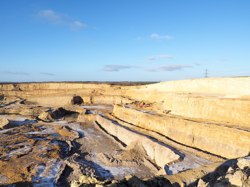
Raisby Hill lies just under two kilometres east of Coxhoe, on the magnesian limestone escarpment that runs down east Durham. The quarry appears in the official Lists of Quarries from 1896 onwards: two hundred and seventy employed that year, three hundred and two in 1897, two hundred and sixty-eight in 1905. Limestone in 1896, limestone and dolomite from 1897, dolomite and limestone in 1922. By then the workforce had fallen to a hundred and eighteen, of whom a hundred and fifteen were returned as below ground. It was dangerous work, and the Mines Inspectors' reports read like a catalogue of falls: Hugh McCutcheon killed in 1900 by a stone thrown sixty yards by a powder shot; Patrick Gavin in 1903, whose pinch bar slipped and who fell seventy feet to the quarry bottom; Michael Roche the same year, jumping back from a fall of baring and going over the edge, a hundred and twenty-eight feet; Richard Mann burnt in 1909 pouring powder into a hole he had cracked minutes before; John Webb in 1913, killed by a small stone thrown a hundred and forty yards by forty-eight pounds of gunpowder while he stood at the face edge watching the effect of his own shot. Henry Robson, who was not employed there at all, climbed the protective fence in 1900 and fell ninety feet. The Raisby Hill Limestone Company held it for most of that period and Raisby Quarries Ltd in the 1980s. It is still a working quarry.
Geology
The quarry exposes a section through the Marl Slate and the Ford and Raisby Formations of the Upper Permian, and is the type locality for the Raisby Formation, a carbonate unit of the English Zechstein sequence. The exposed sequence begins with the Yellow Sands, overlain by the Marl Slate and some two hundred feet of calcareous and dolomitic limestones.
Workings
A large open quarry worked in benches, or posts — the word runs through every inspector's report on the place. Faces of seventy to a hundred and twenty-eight feet are described in the fatality reports. Shot firing with gunpowder in vertical holes; one charge in 1913 was forty-eight pounds in a hole thirteen feet six inches deep.
What remains
A working quarry, and since 1957 a Site of Special Scientific Interest of national importance in the Geological Conservation Review. Until 1984 the designated site included most of what is now the separate Raisby Hill Grassland SSSI.
The quarry is in production; there is nothing disused to record.
Related mines
- Marsden Quarry — Both work the Permian magnesian limestone of east Durham, and both are returned in the official Lists of Quarries with most of their workforce below ground — an oddity of the way this stone was got.
Nearby mines
- Trimdon Grange Colliery — 2.9 km E
- Thrislington Colliery — 3.4 km SW
- Thornley Colliery — 3.5 km NE
- Bishop Middleham Colliery — 4.1 km S
- Fishburn Colliery — 4.2 km SE
Straight-line distance, within 15 km. Show on the map.
Recorded claims
Individual factual claims, each attached to the source(s) that support it below. Where sources disagree, both are kept.
- The quarry exposes a section through the Marl Slate and the Ford and Raisby Formations of the Upper Permian. It is the type locality for the Raisby Formation, a carbonate unit of the English Zechstein sequence. The exposed sequence commences with the Yellow Sands, overlain by the Marl Slate and some two hundred feet of calcareous and dolomitic limestones. 1
- The official Lists of Quarries give 270 employed in 1896, 302 in 1897 and 268 in 1905, falling to 118 by 1922, of whom 115 were returned as below ground. The stone is limestone in 1896 and limestone and dolomite from 1897 onwards. 2
- Thirteen deaths are recorded at Raisby Hill between 1900 and 1951, most of them falls from the posts or stone thrown by shots. John Webb, killed in 1913, and another workman had fired a charge of forty-eight pounds of gunpowder early in the morning, then gone a hundred and forty yards along the top of the face to watch the effect; a small stone struck him on the head and killed him instantly. The inspector noted they could have sheltered in a cabin in the quarry and should in any case have retired from the face edge. 2
- Raisby Hill Quarry is a Site of Special Scientific Interest, established in 1957 and covering 52.42 hectares. The site is a working quarry and has been designated as of national importance in the Geological Conservation Review. Until 1984 it included most of the area that now forms the Raisby Hill Grassland SSSI. 1
- The Geological Conservation Review describes Raisby Quarries as amongst the largest man-made excavations in northern England, and the type locality of the Raisby Formation, the whole of which is exposed in the north face at perhaps 58 m thick. The Marl Slate, 0.2 to 0.9 m, underlies it, with the basal beds of the Ford Formation at the top of the main face and Basal Permian Yellow Sands in part of the quarry. 3
- Raisby Quarries are well known because the Raisby Formation here contains a thick mass of limestone in place of the more usual dolomite rock, with diagenetic breccias through part of the sequence. A substantial range of secondary minerals has been reported from the quarries, including small amounts of native copper. Westphalian B Coal Measures have been temporarily exposed and worked in the quarry floor. 3
Photographs & further reading
The returns from 1896 to 1984 and thirteen named dead, each with the inspector's account of how it happened.
View sourceThe SSSI designation and the geology — the Marl Slate, the Ford and Raisby Formations, and why this is the type locality for the Raisby Formation.
View sourceThe formal site account behind the SSSI: the section, the thickness of the Raisby Formation, the anomalous limestone, the secondary minerals and the literature.
View sourceSources
- (secondary) Raisby Hill Quarry — Wikipedia
- (secondary) Raisby Hill Quarry (Limestone) — Durham Mining Museum
- (primary) Raisby Quarries, Geological Conservation Review site account — Joint Nature Conservation Committee
Record created: 11 September 2026 · Last researched: 11 September 2026