 MineArchive
Rainford Colliery
| Also known as | Brynn Hall Colliery |
|---|---|
| Location | Rainford, near St Helens, Merseyside — 53.5114, -2.8108 (approximate) |
| Commodity | Coal |
| Type | Coal |
| Worked | Mid 1860s–c. 1928 or 1929 |
| Maximum depth | 200 yards (Nos. 3 and 4, to the Arley) |
| Operators | Rainford Coal Co. Ltd (1892–1903), Bromilow, Foster and Co. Ltd (1903–1929) |
Overview
Two pairs of shafts beside the railway west of Rainford Junction, sunk from the mid-1860s. Seven or more men died in a shaft fire during the 1869 deepening. Worked by the Rainford Coal Company and then Bromilow, Foster and Co., it closed in the late 1920s.
History
Rainford Colliery, also called Brynn Hall, lay about a mile west of Rainford Junction, beside the Wigan-Liverpool line and just west of the St Helens-Ormskirk road. Nos. 1 and 2 were sunk in the mid-1860s through sixteen feet of wet gravel and sand to the Seven Feet (Lindsay) at 160 yards. Nos. 3 and 4, about 200 yards away, went to the Arley at 200 yards.
In January 1869, during the deepening, a fire in the shaft pillars killed nine men (see Disasters, below). The Rainford Coal Company held the colliery in 1892 and went into liquidation in September 1903. Bromilow, Foster and Co. restarted it that December. In 1923 Nos. 1 and 2 employed 455, working the Arley, Rushy Park and Seven Feet. Decline followed the 1926 strike, and the colliery closed around 1928-29. A square brick chimney still stood in the 1950s.
Geology
Lancashire Coal Measures beneath wet glacial gravel and sand: Seven Feet (Lindsay or Haigh Yard) at 160 yards, Rushy Park, and Arley at 200 yards.
Workings
Nos. 1 and 2 (to the Seven Feet) and Nos. 3 and 4 (to the Arley), 200 yards apart; flat-rope and drum winders; flat-rod pumping in two bucket lifts; endless-rope and compressed-air haulages; Schiele fans; Galloway, Lancashire and egg-end boilers; a sawmill.
Closure
Restarted after the 1903 liquidation; declined after the 1926 strike and closed around 1928-29. The reason given locally is the 1926 strike.
What remains
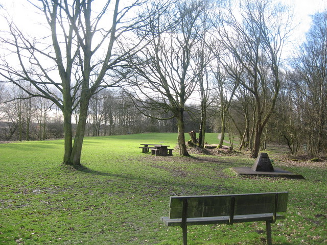
A Geograph photograph shows the site as the Siding Lane Local Nature Reserve.
Redevelopment
The colliery site is the Siding Lane Local Nature Reserve.
Nearby mines
- Bickerstaffe Colliery — 1.8 miles (2.8 km) NW, Lancashire
- Holland Colliery — 2.4 miles (3.9 km) E, Lancashire
- Blaguegate Colliery — 3.5 miles (5.6 km) N, Lancashire
- Tawd Vale Colliery — 3.6 miles (5.7 km) N, Lancashire
- Alexandra Colliery — 5.4 miles (8.7 km) SE
Straight-line distance, within 9 miles (15 km). Show on the map.
Disasters & major incidents
-
Rainford Colliery shaft fire, 1869
8-9 January 1869 · Fire · 9 fatalities
In January 1869 the ventilating furnace at Rainford Colliery set fire to the coal pillars left to support the shafts, which were being deepened. Seven men preparing to put the fire out with water were fatally burned when the flame turned on them. The next night two enginemen fell to their deaths when the scaffold over the shaft gave way.
What's uncertain
Points where sources disagree or the record could not be settled; both accounts are kept. All open questions in the archive.
- Final closure about 1929. (disputed) 1
- The shaft was sunk in 1860 through sixteen feet of wet gravel and sand; the colliery declined after the 1926 strike and closed in 1928. (disputed) 3
Recorded claims
Individual factual claims, each attached to the source(s) that support it below. Where sources disagree, both are kept.
- Nos. 1 and 2 were sunk in the mid-1860s to the Seven Feet at 160 yards. 1
- Nos. 1 and 2 employed 455 in 1923. 2
- Final closure about 1929. (disputed) 1
- The shaft was sunk in 1860 through sixteen feet of wet gravel and sand; the colliery declined after the 1926 strike and closed in 1928. (disputed) 3
- Its plans show the Rushy Park, Seven Feet (Haigh Yard) and Arley. 4
Photographs & further reading
Both pairs of shafts, winding, pumping, ventilation, the 1869 fire and closure, from the G. Hayes collection.
View sourceOwners, seams, employment and fatalities.
View sourceSources
- (secondary) Rainford (Brynn Hall) Collieries — Northern Mine Research Society
- (primary) Rainford Colliery — Durham Mining Museum
- (observational) Site of Rainford Colliery (Siding Lane Local Nature Reserve) (photograph) — Geograph
- (primary) Mine plan: Rainford, Rushy Park — British Geological Survey
Record created: 2 October 2026 · Last researched: 2 October 2026