 MineArchive
Porthgain Quarries
| Also known as | Porth-gain Quarries, Penclegyr Quarry, St Brides Quarries |
|---|---|
| Location | Porthgain, Llanrhian, Pembrokeshire — 51.9481, -5.1811 (exact) |
| Commodities | Slate, Whinstone |
| Type | Quarry |
| Worked | 1831–1931 |
| Operators | United Stone Firms Ltd (1913–?, owner) — Owners in the 1913 accident return; their vessels loaded roadstone until the 1930s Porthgain Quarries Ltd (owner) — Owners in the 1906 accident return |
The slate pit, brickworks and dolerite quarries at Porthgain on the north Pembrokeshire coast, whose stone left by sea from 1851 until the crushing plant closed in 1931.
Location
Recorded location. The large pin is this mine; the small round markers are the nearest mines on record. Click one for its page. View on full map
History
Porthgain, on the north Pembrokeshire coast, grew up around a slate quarry. The pit behind the harbour, part of the St Brides quarries, opened in 1831 by one account, though the scheduling record has quarries in the area working from at least 1800. Its slate came down an incline to a mill near the harbour driven by a water wheel, and the harbour itself was built in about 1850-51 to ship slate from Porthgain and from Abereiddi, two miles to the south. As the pit deepened, steam and then a ropeway hauled the slate up, and later a tunnel driven below the pit floor let wagons be loaded by chute.
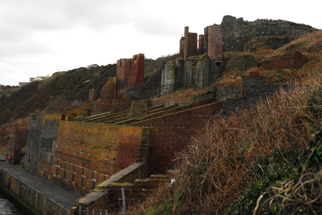
By the end of the century the slate was turning to shale, and only four men worked the pit in 1898. The company found a use for the waste all the same. From about 1889 it turned the slate waste into bricks, an unusual process in Britain at the time; in 1909 there were 600,000 bricks in the yard. The brickworks closed in 1911 and slate working stopped in 1910. Meanwhile the dolerite of the headland to the west, at Penclegyr, was quarried for roadstone and crushed stone, exported from about 1878. A locomotive railway brought it to a crushing plant above the harbour, and brick hoppers along the quay fed the company's six 350-ton coasters. The harbour was enlarged between 1902 and 1904, and in the summer of 1909 alone 101 cargoes, 13,000 tons, went out.
Porthgain Quarries Ltd owned the works in 1906, when a foreman was killed by a charge of gelignite, probably frozen, that went off as he and his son lit it, and United Stone Firms Ltd had them by 1913. Trade never recovered after the First World War, and the crushing plant closed in 1931. The harbour, hoppers and crushing plant were scheduled as an ancient monument in 1972, and in the 1980s the village became a conservation area, its industrial land bought by local residents and the National Park Authority.
Geology
Ordovician slate in the pit behind the harbour, deteriorating to shale; dolerite on the headland to the west worked for roadstone.
Workings
A slate pit with incline, mill, ropeway and a tunnel below the pit floor; two adjacent coastal stone quarries on two levels, the lower about 150 by 100 metres, with a cable incline, a locomotive railway to a crushing plant and brick storage hoppers on the quay.
Closure
Slate working stopped in 1910, the brickworks closed in 1911 and the crushing plant in 1931.
What remains
A scheduled monument and conservation area: the harbour and its brick hoppers, the crushing plant ruins, the slate pit and the coastal quarries survive, and the harbour is used by fishing boats.
The brick storage hoppers, the remains of the crushing and grading plant, the harbour quays and pilot house, the slate pit and its tunnel, the brickworks building, the stone quarries, railway and weighbridge remains and quarrymen's cottages.
Redevelopment
The industrial land was bought by local residents and the Pembrokeshire Coast National Park Authority in the 1980s; the harbour serves fishing and pleasure boats.
Related mines
- Abereiddi Slate Quarry — The Abereiddi pit was worked with the Porthgain quarries: its slate went by the Porthgain to Abereiddi tramway to Porthgain harbour, and the 1907 map names it the Porth-gain Slate Quarries (Coflein, NPRN 40620 and 400060).
Nearby mines
- Abereiddi Slate Quarry — 1.4 miles (2.2 km) SW
- Trefrane Cliff Colliery — 8.4 miles (13.5 km) S
Straight-line distance, within 9 miles (15 km).
Further reading
The Royal Commission's record of the Porthgain industrial complex: exports, harbour enlargement, shipments in 1909 and closure in 1931.
View sourceCadw's scheduling report for the harbour, crushing plant and hoppers.
View sourceSources
- (primary) St Brides Quarries (Coflein, NPRN 420734) — RCAHMW
- (primary) Porthgain Quarry and Harbour (Cadw scheduled monument report) — Cadw
- (primary) Porthgain Harbour (Coflein, NPRN 34343) — RCAHMW
- (primary) Porthgain Brickworks (Coflein, NPRN 40815) — RCAHMW
- (secondary) Porthgain (Wikipedia) — Wikipedia
- (primary) Porthgain (Coflein, NPRN 33206) — RCAHMW
- (observational) Abereiddi and Porthgain, Pembrokeshire, August 2013 (Derelict Places) — Derelict Places
- (secondary) NMRS deaths and injuries database: Porthgain Quarry, 1906 — Northern Mine Research Society
- (secondary) NMRS deaths and injuries database: Porthgain Quarry, 1913 — Northern Mine Research Society
- (primary) Porthgain Stone Quarry (Coflein, NPRN 420705) — RCAHMW
Record created: 20 November 2026 · Last researched: 20 November 2026