 MineArchive
Kepier Colliery
| Also known as | Florence Pit, Kepier |
|---|---|
| Location | North of the Sunderland road, Gilesgate, on the eastern edge of Durham City, County Durham — 54.7806, -1.5514 (approximate) |
| Commodity | Coal |
| Type | Coal |
| Worked | from By 1818 |
| Maximum depth | 557 ft (170 m), Florence Pit No. 2 shaft |
| Operators | Wear Coal Company |
Overview
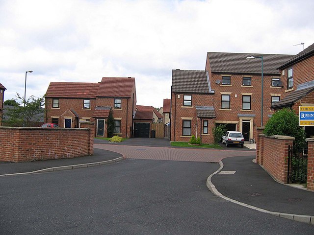
A colliery on the Sunderland road at the eastern edge of Durham, near Gilesgate, worked by 1818, with a branch to the railway at Gilesgate station. The Wear Coal Company sank its Florence Pit to the Busty seam in the 1870s; the site later became a green known locally as 'the Duffy' and is now housing.
History
Kepier Colliery lay just north of the Sunderland road on the eastern edge of Durham, north of Glue Garth near Gilesgate, one of a group of collieries round Kepier with Kepier Grange and Grange. Its first shaft was sunk through 60 feet of clay to the Hutton seam at about 264 feet, and in 1818 a boring was put down below the Hutton without finding anything worth working. Plans of its Hutton workings date from 1837 and of its Low Main from 1849, and in 1852 borings were made to prove the Busty. Ralph Dixon owned the colliery in the 1850s and John Thwaites in the 1860s; it had a branch line to the Newcastle and Darlington Junction railway at Gilesgate station.
Its Hutton and Low Main workings had been abandoned before 1872, when the Wear Coal Company began the Florence Pit; its No. 2 shaft was sunk to the Busty seam and reached 557 feet. A boring at the Kepier New Pit in 1876 to prove the lower seams gave disappointing results. Hewers and putters were killed by falls of stone there from 1847 to 1871, among them two boys of 14 and 16. One local history has the colliery closing in the early 1900s. In later years its site was a green, known locally as 'the Duffy', and it is now covered by housing.
Geology
Durham coalfield: the Low Main, Brass Thill and Hutton seams, and the Busty below.
Workings
A shaft to the Hutton, the Engine, Mary and Florence pits, the Florence Pit's No. 2 shaft to the Busty, and a branch line to Gilesgate station.
Closure
One local history gives the early 1900s; the Durham Mining Museum records output only to 1873.
What remains
The site is covered by modern housing.
Redevelopment
A green known locally as 'the Duffy', then housing.
Nearby mines
- Houghall Colliery — 1.6 miles (2.5 km) S
- Framwellgate Moor Colliery — 1.8 miles (2.9 km) NW
- Shincliffe Colliery — 1.9 miles (3.0 km) S
- Cocken Colliery — 2.8 miles (4.5 km) N
- Bearpark Colliery — 2.8 miles (4.6 km) W
Straight-line distance, within 9 miles (15 km). Show on the map.
What's uncertain
Points where sources disagree or the record could not be settled; both accounts are kept. All open questions in the archive.
- The colliery closed in the early 1900s. (uncertain) 1
Recorded claims
Individual factual claims, each attached to the source(s) that support it below. Where sources disagree, both are kept.
- Kepier Colliery was north of Glue Garth on the Sunderland road, with a branch line to the Newcastle and Darlington Junction railway at Gilesgate station. 1,2
- A boring was put down below the Hutton seam at Kepier Colliery in 1818; nothing was found. 3,4
- The No. 2 shaft of the Florence Pit was sunk to the Busty seam, reaching 557 feet. 3,5
- Ralph Dixon owned the colliery in the 1850s, John Thwaites in the 1860s and the Wear Coal Company in the 1870s. 3
- Kepier's Hutton and Low Main workings were abandoned before 1872. 6
- The colliery closed in the early 1900s. (uncertain) 1
- In more recent times a green known as 'the Duffy' occupied the colliery site, now built over. 7
- Plans of Kepier workings in the Hutton are dated 1837, in the Low Main 1849, and in the Low Main again 1872. 8
Photographs & further reading
Owners, pits, borings and the men killed at the colliery, 1847-1871.
View sourceSources
- (secondary) Gilesgate — Durham City Tales
- (secondary) Local History — Belmont Parish Council
- (primary) Kepier Colliery — Durham Mining Museum
- (primary) Kepier Colliery: strata sunk through at Kepier Colliery — Durham Mining Museum
- (primary) Kepier Colliery: strata sunk through in No. 2 Shaft, Florence Pit — Durham Mining Museum
- (primary) Kepier Colliery: catalogue of plans of abandoned mines — Durham Mining Museum
- (observational) Mackintosh Court (Geograph 485196) — Roger Smith via Wikimedia Commons
- (primary) BGS mine plan: Kepier, Hutton, abandoned 1837 — BGS / Mining Remediation Authority mine plans

Record created: 5 October 2026 · Last researched: 5 October 2026