 MineArchive
Holme Bank Chert Mine
| Also known as | Bakewell Chert Mine, Smith's Mine, Castle Hill Mine, Holme Hall Chert Mine |
|---|---|
| Location | Castle Hill and Holme Bank, Bakewell, Derbyshire — 53.2190, -1.6803 (exact) |
| Commodity | Chert |
| Type | Mineral |
| Worked | 1832–1959–1961 |
| Maximum depth | Adits into the hillside from a quarry face about 5 metres deep; no shaft. |
Overview
An underground chert mine at Bakewell, worked for the stone that ground flint for the pottery industry. The technology for using chert to crush flint was developed in the mid-eighteenth century and Bakewell chert was in the Potteries from about that time; the Holme Bank quarry is first documented by name in 1832 and underground working had begun by the middle of the century. Holme Bank and the neighbouring Holme Hall mine worked under different ownerships but shared surface works and, for much of their later history, an entrance. The chert industry peaked at the end of the nineteenth century and declined rapidly; small-scale production continued to 1960 and the mine closed between 1959 and 1961.
History
Chert was worked into tools in prehistory, but the industry here rests on an eighteenth-century discovery: that chert, ground wet, made a better mill-stone for crushing calcined flint than flint itself. Calcined flint was the whitening agent in earthenware, and the Potteries needed it in quantity. The technology was developed in the mid-eighteenth century and chert from the Bakewell area was certainly in use in the Potteries from around that time. When work started at Holme Bank itself is uncertain. The quarry is first documented by name in 1832, and underground working must have begun by the mid-nineteenth century, because the neighbouring Holme Hall mine is first documented in 1853. The two were separate concerns mining under land in different ownerships, but they shared the same surface works and over much of their later history a shared entrance. The quarry was being worked before 1880, when it was known as Bakewell Chert Mine and also as Smith’s Mine. The chert industry reached its peak at the end of the nineteenth century and declined rapidly afterwards, though small-scale production from the mines continued from the 1920s until 1960. The mine closed between 1959 and 1961.
Geology
Beds of chert within the Carboniferous limestone of the Derbyshire Dome. Chert is a dense, fine-grained silica rock — the same material as flint but bedded rather than nodular — and it is its hardness and even texture that made it valuable: a chert runner grinding calcined flint wears slowly and sheds nothing that would discolour the body. That is why the Potteries bought Derbyshire chert rather than using flint on flint.
Workings
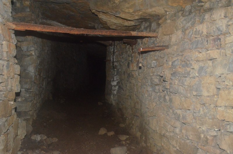
Adits driven into the north-east face of a quarry, leading to extensive underground workings. Eight entrances are known, the main ones in the old quarry. The surface works were shared with the Holme Hall mine, and the quarry retains buildings and equipment from nineteenth and twentieth-century chert working, including the remains of a water pump and railway lines.
Closure
The chert trade did not so much end as dwindle: peak at the close of the nineteenth century, rapid decline after it, and then four decades of small-scale production before the mine shut between 1959 and 1961. Synthetic and imported grinding media, and changes in pottery manufacture, removed the market.
What remains
The dominating surface feature is a large disused quarry with an exposed rock face about five metres deep; in its north-east face are the entrances of two adits leading to the extensive underground workings. The quarry contains a number of buildings and items of equipment associated with nineteenth and twentieth-century chert mining. Parts of the workings are flooded and have been used by cave divers for training.
The quarry face and its adit entrances, buildings and equipment from the working period, and the remains of a water pump and railway lines recorded underground.
Nearby mines
- Maypit Mine — 1.5 miles (2.3 km) S
- Dirty Red Soil Mine — 1.5 miles (2.4 km) S
- Great Red Soil Mine — 1.5 miles (2.4 km) S
- Horsesteps Mine — 1.5 miles (2.5 km) S
- Mandale Mine — 2.2 miles (3.5 km) SW
Straight-line distance, within 9 miles (15 km). Show on the map.
Recorded claims
Individual factual claims, each attached to the source(s) that support it below. Where sources disagree, both are kept.
- The Holme Bank chert quarry and mine and the Holme Hall chert mine shared the same surface works, but each mined underground under land in different ownerships; over much of their later history they had a shared entrance. 1
- When work started here is uncertain. The technology for using chert to crush flint for the pottery industry was developed in the mid-18th century, and chert from the Bakewell area was certainly in use in the Potteries from around this time. The first documentation of the Holme Bank quarry by name is 1832, and underground working must have begun by the mid-19th century, as the Holme Hall mine is first documented in 1853. 1
- The quarry was being worked before 1880, when it was known as Bakewell Chert Mine and also as Smith’s Mine. 1
- The chert industry reached a peak at the end of the 19th century but declined rapidly after that; small-scale production from the mines continued from the 1920s until 1960. The mine closed between 1959 and 1961. 1
- The dominating surface feature is a large disused quarry with an exposed rock face about 5 metres deep; in its north-east face are the entrances of two adits leading to extensive underground chert mine workings. Eight entrances are known. The quarry contains buildings and equipment associated with 19th and 20th century chert mining, and the remains of a water pump and railway lines have been recorded. 1
Photographs & further reading
The county monument record: the relationship between the two mines, the documented dates, the rise and decline of the chert trade, and what survives above and below ground.
View sourceSources
- (primary) MDR12988 — Holme Bank chert quarry mine and Holme Hall chert mine, Bakewell — Derbyshire Historic Environment Record
- (observational) Holme Bank Chert Mine, Bakewell — exploration reports — 28DaysLater
Record created: 8 September 2026 · Last researched: 8 September 2026