 MineArchive
Gregory Mine
| Location | Ravensnest, Gin Lane, Ashover, Derbyshire — 53.1519, -1.4835 (exact) |
|---|---|
| Commodity | Lead |
| Type | Metal |
| Worked | Early 1700s–1806 |
| Maximum depth | 120 yards (110 m) at the shaft north-west of Ravensnest House |
Overview
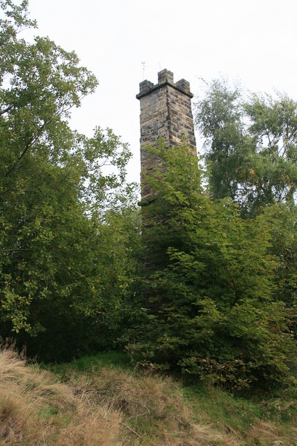
The richest lead mine of the Ashover orefield, worked as the Gregory partnership from 1758 to 1806, which raised about 511 tons of ore a year and cleared £100,000 for its shareholders; its crenellated engine chimney still stands at Ravensnest.
History
The Gregory vein at Ashover was being worked at least fifty years before 1758, when a partnership of the Banks-Hodgkinson family, the ironmaster Isaac Wilkinson and others began the mine under the Gregory name, taken from the Gregory family of Ravensnest near Overton. Francis Thompson installed a pumping engine in 1774, and in 1782 the company made heavy payments to both Thompson and Boulton & Watt, probably for a new engine and pump shaft. Several steam engines were worked by the Thompson family, and the shaft north-west of Ravensnest House was 120 yards deep.
Between 1758 and 1806 the mine raised an average of 511 tons of ore a year, and its shareholders made a clear profit of £100,000 after spending £23,000 prospecting for a new vein. It closed in 1806. Its waste heaps, known locally as the White Hillocks, later carried a fluorspar treatment plant, which the Peak District Mines Historical Society bought, recorded and dismantled in 1999-2000 for storage underground at Middleton.
Geology
The Gregory vein, a lead vein of the Ashover orefield.
Workings
Shafts on the Gregory vein, one 120 yards deep, pumped by several steam engines; a sough ran from the mine to the River Amber.
Closure
The mine closed in 1806.
What remains
A square crenellated gritstone chimney, listed at Grade II, waste heaps known as the White Hillocks and the pools of run-in shafts mark the site.
The engine-house chimney with an inclined flue, waste heaps and collapsed shafts.
Redevelopment
A fluorspar treatment plant later stood on the White Hillocks; it was dismantled in 1999-2000.
Nearby mines
- Clay Cross Colliery — 3.0 miles (4.8 km) E
- Dimple Mine — 3.2 miles (5.2 km) W
- Stone Edge Smelt Mill — 3.3 miles (5.3 km) N
- Riber Mine — 3.4 miles (5.4 km) SW
- Gentlewoman's Pipe — 3.5 miles (5.6 km) SW
Straight-line distance, within 9 miles (15 km). Show on the map.
Recorded claims
Individual factual claims, each attached to the source(s) that support it below. Where sources disagree, both are kept.
- The mine dates under the Gregory name from 1758, when a partnership of the Banks-Hodgkinson family, Isaac Wilkinson and others was formed; the Gregory vein had been worked at least fifty years earlier. 1
- Between 1758 and 1806 the mine yielded an average of 511 tons of ore a year, and shareholders made a clear profit of £100,000. 1
- Francis Thompson installed a pumping engine in 1774, and in 1782 the company paid heavily to Thompson and to Boulton & Watt, probably for a new engine and pump shaft. 1,2
- The Gregory Mine closed in 1806. 1
- The engine-house chimney of the Gregory Mine at Ravensnest is listed at Grade II as the major mining monument of the Ashover orefield. 1,3
- A section of the strata at Gregory's Mine, Ashover, is among the deposited mine plans. 4
Sources
- (secondary) MDR5080 Gregory Mine, Ravensnest Cottages, Ashover — Derbyshire Historic Environment Record
- (secondary) Gregory Lead Mine — Grace's Guide
- (secondary) Chimney at Ravensnest, Ashover (Historic England list entry 1291915) — British Listed Buildings
- (primary) BGS mine plan: Section of the strata at Gregory's Mine, Ashover — British Geological Survey / Mining Remediation Authority
Record created: 19 October 2026 · Last researched: 19 October 2026