 MineArchive
Cornelly Quarries
| Also known as | Cornelly and Grove Quarries, South Cornelly Quarries |
|---|---|
| Location | South Cornelly, west of Bridgend — 51.5116, -3.6995 (exact) |
| Commodity | Limestone |
| Type | Quarry |
| Worked | from From the Industrial Revolution |
| Operators | Tarmac (2000–?) |
Overview
The largest producer of high-quality limestone in South Wales, and the reason Port Talbot can make steel — over a million tonnes a year of stone so pure that half of it goes not as aggregate but as flux.
History
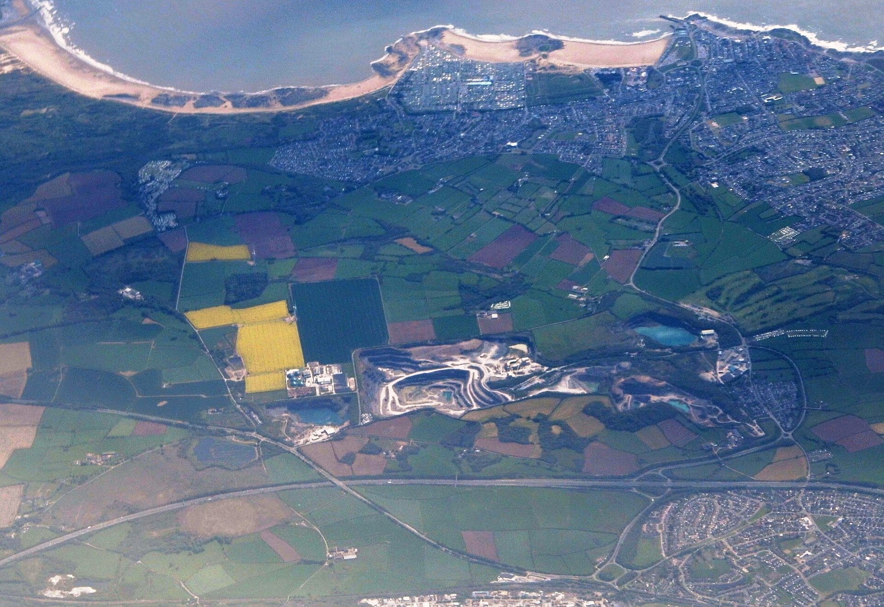
Limestone has been taken from the common west of Bridgend for a very long time, but large-scale exploitation came with the Industrial Revolution and the enormous appetite of the South Wales iron industry for flux. The furnaces at Cefn Cribwr, Aberkenfig and Maesteg wanted lime, and their successors at Port Talbot and Briton Ferry wanted more of it — which is why the ground around Cornelly is an extensive landscape of abandoned quarries with a few very large working ones among them. Cornelly and its neighbour Grove are still going. Lime-burning on Stormy Down began in a small way in the middle of the seventeenth century, when coal became cheap enough to fire kilns: groups of two or three men opened small quarries and built kilns, selling lime for fertiliser, mortar and limewash. Large-scale working came with the ironworks at Cefn Cribwr, Aberkenfig and Maesteg, which needed lime as a flux, and was carried on by their successors at Port Talbot and Briton Ferry; the scarred valley running up the western slope of Stormy Down, with the flooded Pant Mawr quarry known locally as the Blue Lagoon, is the result. The modern Cornelly, Grove and Gaens quarries work under consents that pre-date the planning system and an Interim Development Order of the 1940s. Their periodic review began with applications in 1997 that the Welsh Office called in in 1998, an environmental impact assessment in 2003, a further review application in 2009 called in by the Welsh Government in 2010 and an environmental statement in 2014, leading to a public inquiry; the main issue throughout has been the effect on groundwater at the Kenfig dunes.
Geology
The stone is Carboniferous limestone, and the point about it is purity: the majority of the Bridgend reserves run better than 97 per cent calcium carbonate. That is what separates a flux quarry from an aggregate quarry. Ordinary limestone can be crushed for roadstone; only very pure limestone can be ground into the 'sinter' that a blast furnace needs to carry impurities out of the iron as slag, and it is the high-purity reserves that give Cornelly its national importance rather than its size alone. The quarry is the type section of the Cornelly Oolite Formation: thick-bedded, cross-bedded pale grey ooid grainstones of Arundian to Holkerian age, 135 to 180 metres thick across the Vale of Glamorgan, lying between the High Tor Limestone below and the Stormy Limestone above.
Geological setting: Sedimentary Beds and Seams (well documented example)
Workings
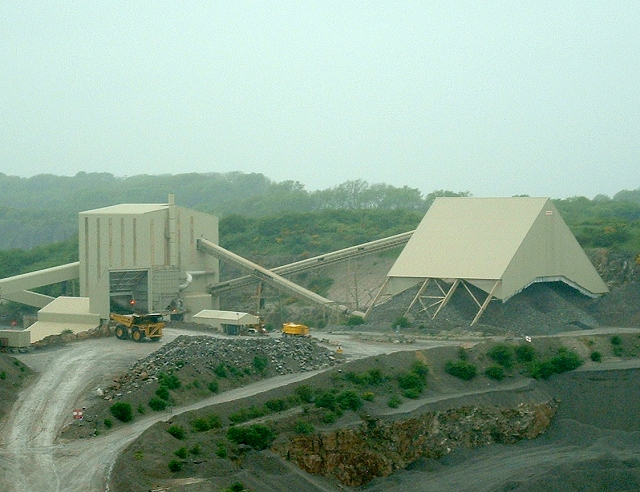
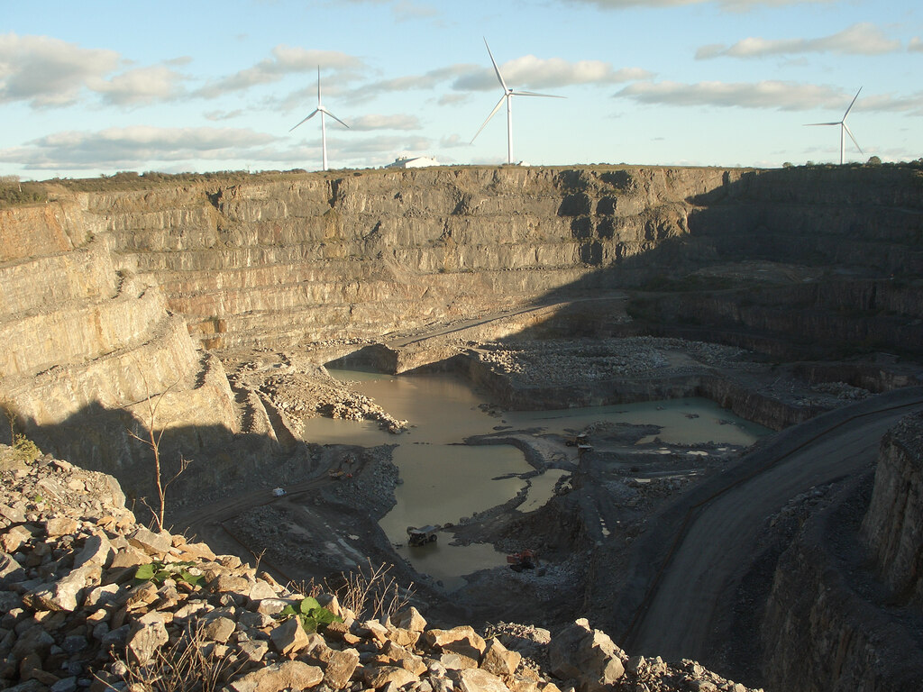
Large open quarries worked by drilling and blasting, with crushing and grinding plant on site. Cornelly is worked together with the adjoining Grove quarry; between them and Gaens they account for effectively all of Bridgend's crushed rock aggregate output. Roughly half of Cornelly's production between 2010 and 2018 went as non-aggregate — high-grade ground limestone for industry rather than stone for roads.
Closure
Cornelly has not closed and shows no sign of doing so: the council's own minerals assessment put the non-aggregate reserves alone at enough for at least 45 years from 2018.
What remains
A large working quarry, not accessible to visitors. The abandoned quarries around it are a conspicuous feature of the landscape between Cornelly and Kenfig.
The working faces and plant, and an extensive spread of older abandoned quarries across the common.
Redevelopment
None — still in production, with a 200 m buffer zone maintained between the quarries and nearby settlement.
Nearby mines
- Cribbwr Fawr Colliery — 1.7 miles (2.7 km) N
- Newlands Colliery — 2.0 miles (3.1 km) N
- Bryndu Colliery — 2.1 miles (3.5 km) NE
- Aberbaiden Colliery — 3.1 miles (5.0 km) NE, Neath Port Talbot
- Ton Phillip Colliery — 3.7 miles (5.9 km) NE
Straight-line distance, within 9 miles (15 km). Show on the map.
Recorded claims
Individual factual claims, each attached to the source(s) that support it below. Where sources disagree, both are kept.
- The Bridgend Carboniferous limestone is mostly over 97 per cent pure, which is what makes it valuable as steelmaking flux rather than merely as aggregate. 1
- Large-scale working came with the Industrial Revolution and the demand for lime as a flux from the ironworks at Cefn Cribwr, Aberkenfig and Maesteg, and later Port Talbot and Briton Ferry. 1
- Roughly half of Cornelly's output between 2010 and 2018 was non-aggregate — high-grade ground limestone for industry. 1
- Cornelly/Grove and Gaens together account for effectively all of Bridgend's crushed rock aggregate production, and the county's limestone quarries supply about 8.7 per cent of the South Wales total. 1
- Non-aggregate reserves at Cornelly were assessed in 2018 as sufficient for at least 45 years. 1
- Cornelly Quarry is the type section of the BGS's Cornelly Oolite Formation, pale grey ooid grainstones 135 to 180 m thick between the High Tor and Stormy Limestone formations. 2
- Gaens, Grove and Cornelly quarries operate under consents pre-dating the planning system and a 1940s Interim Development Order; review applications of 1997 and 2009 were called in by the Welsh Office and Welsh Government, with environmental assessments in 2003 and 2014 and a public inquiry. 3
- Lime-burning on Stormy Down began in the mid-seventeenth century with small quarries and kilns worked by two or three men, and grew with the demand for flux from the Cefn Cribwr, Aberkenfig and Maesteg ironworks. 4
Photographs & further reading
The Kenfig heritage site's account of lime-burning on Stormy Down from the seventeenth century to the modern quarry, its wildlife and the Blue Lagoon.
View sourceSources
- (primary) Bridgend Replacement LDP background paper 14: Minerals — Bridgend County Borough Council
- (primary) BGS Lexicon of Named Rock Units: Cornelly Oolite Formation — British Geological Survey
- (primary) Review of Old Mineral Planning Consents (ROMP): Cornelly Quarries — Bridgend County Borough Council
- (secondary) Cornelly Quarry — Kenfig: The Complete History — Kenfig.org
- (primary) Geology of the South Wales Coalfield: Bridgend, sheets 261 and 262 — British Geological Survey
Record created: 24 August 2026 · Last researched: 8 September 2026