 MineArchive
Bretby Colliery
| Also known as | Newhall Park Colliery |
|---|---|
| Location | Newhall Park, Park Road, Stanton, west of Swadlincote, Derbyshire — 52.7768, -1.5966 (exact) |
| Commodities | Coal, Fireclay |
| Type | Coal |
| Worked | 1872–May 1962 |
| Maximum depth | 171 yards (156 m), the deepest of its three shafts |
| Operators | Hall's Collieries Ltd (1920–1947), National Coal Board (1947–1962) |
Overview
The colliery at Newhall Park, west of Swadlincote, sunk in 1872-76 for the Countess of Chesterfield and worked for 86 years. The Earl of Carnarvon owned it from 1890 and Hall's Collieries from 1920; closed as unprofitable in 1928, it reopened and worked on until the Nether Main was exhausted in May 1962.
History
A shaft was first sunk on the Newhall Park site about 1790. An earlier Bretby No. 1, sunk in 1854, worked the Eureka, Woodfield and Stanhope seams until 1886, and a Bretby Colliery No. 1 named on the 1884 map beside the Bretby Colliery branch railway had given way to a saw mill by 1924. The main colliery, at Newhall Park south-west of Newhall, was sunk in 1872-76 for the Countess of Chesterfield; it appears as Newhall Park Colliery on the Ordnance Survey of about 1880 and as Bretby Colliery by about 1900. The Earl of Carnarvon took it over in 1890 and made a new sinking of Nos. 1 and 2 pits in 1893-94; its three shafts were 90, 144 and 171 yards deep.
The colliery employed 579 in 1894 and between about 360 and 580 for the next fifty years, in the Eureka, Stanhope, Nether, Woodfield, Kilburn and Deep Hard seams, with fireclay by 1915. Hall's Collieries took it over in 1920. It was closed in 1928 as unprofitable but reopened, and passed to the National Coal Board in 1947, when 446 people raised 220,000 tons. The Great Newhall Sough, a brick-lined drain some two and a half miles long, was cleaned out regularly in the 1950s to keep its water out of the colliery.
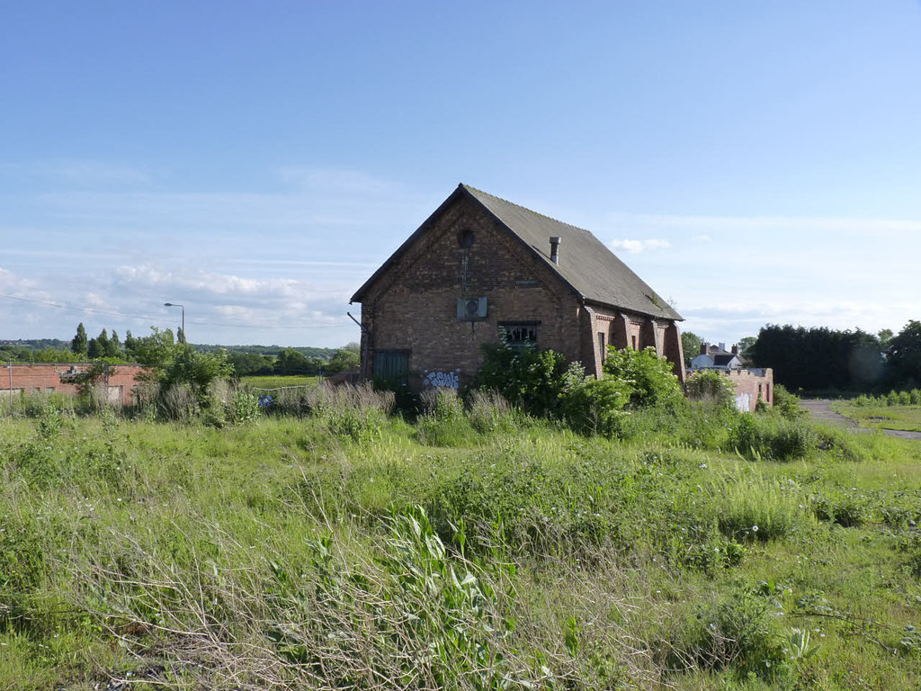
The Kilburn seam, worked on and off since 1922, was finally closed by underground water, and the Nether Main, reopened in December 1958, was exhausted in May 1962, ending the colliery after 86 years. Its buildings found further use as industrial premises; the former winding house is the last of them standing.
Geology
South Derbyshire coalfield: the Eureka, Stanhope, Nether, Woodfield, Stockings, Main, Kilburn and Deep Hard seams, with fireclay.
Workings
Three shafts of 90, 144 and 171 yards; Nos. 1 and 2 pits newly sunk in 1893-94; an earlier Bretby No. 1 (1854-1886).
Closure
Closed in May 1962 when the Nether Main was exhausted; the Stockings plans are dated 29 July 1961. Earlier closed in 1928 and reopened.
What remains
The pithead site is occupied by works and a depot in light industrial use.
The former winding house survives, the last colliery building on the site; a brick building of Bretby Colliery No. 1 stands on Ashby Road East.
Redevelopment
Unknown.
Related mines
- Swadlincote Colliery — Hall's Collieries pits.
Nearby mines
- Cadley Hill Colliery — 0.6 miles (1.0 km) SE
- Swadlincote Colliery — 1.2 miles (1.9 km) E
- Granville Colliery — 2.1 miles (3.3 km) E
- Netherseal Colliery — 2.9 miles (4.6 km) S
- Moira Collieries — 4.0 miles (6.4 km) SE, Leicestershire
Straight-line distance, within 9 miles (15 km). Show on the map.
Recorded claims
Individual factual claims, each attached to the source(s) that support it below. Where sources disagree, both are kept.
- Bretby Colliery at Newhall Park was sunk in 1872-1876 for the Countess of Chesterfield. 1
- Bretby's owners were the Earl and Countess of Chesterfield, the Earl of Carnarvon from 1890 and Hall's Collieries Ltd from 1920. 2,1
- The colliery appears as Newhall Park Colliery on the Ordnance Survey of about 1880 and as Bretby Colliery by about 1900. 3
- Bretby employed 579 in 1894 and 446 in 1947, when it raised 220,000 tons. 2
- Bretby closed in May 1962 after 86 years. 4,1
- Bretby Colliery No. 1, named on the 1884 map, was a saw mill by 1924; one of its brick buildings survives. 5
- Bretby's Stockings workings were abandoned on 29 July 1961. 6
- The former winding house is the last surviving colliery building. 7
Photographs & further reading
Owners, employment, seams and those killed.
View sourceBob Bradley's notes on the sinkings, seams and manpower.
View sourceThe colliery site on successive Ordnance Survey maps.
View sourceSources
- (secondary) 1962 - B (Bob Bradley) — Healey Hero
- (primary) Bretby Colliery — Durham Mining Museum
- (secondary) MDR6965 - Bretby Colliery (site of), Park Road, Stanton — Derbyshire Historic Environment Record
- (secondary) NCB Collieries - England (Northern Mine Research Society) — Northern Mine Research Society
- (secondary) MDR7994 - Bretby Colliery No. 1 (site of), Ashby Road East, Bretby — Derbyshire Historic Environment Record
- (primary) BGS mine plan: Bretby, Stockings, abandoned 29 July 1961 — BGS / Mining Remediation Authority mine plans
- (observational) Former winding house, Bretby Colliery (Geograph 4034800) — Geograph
Record created: 4 October 2026 · Last researched: 4 October 2026