 MineArchive
Breich No. 1 and 2 Pits
| Also known as | Mid Breich, Mid Breich Pits Nos 1 and 2, Breich Mine |
|---|---|
| Location | Mid Breich, Livingston parish, West Lothian, south of Seafield, West Lothian — 55.8673, -3.5907 (approximate) |
| Commodity | Oil Shale |
| Type | Mineral |
| Worked | 1912–1961 |
| Maximum depth | 72 fathoms (132 m) to the Dunnet Shale |
| Operators | Pumpherston Oil Company (1903–1961, owner) — Bought the Breich mineral rights after the New Hermand company's 1903 liquidation and sank the pits (Scottish Shale) |
The Pumpherston Oil Company's deep shale pits at Mid Breich, West Lothian, sunk to the Dunnet Shale by 1912 and among the first in the shale field to wind and ventilate by electricity. They supplied Seafield and then Westwood oil works until 1961.
Location
Approximate location. The large pin is this mine; the small round markers are the nearest mines on record. Click one for its page. View on full map
History
The shale under Breich was held by the New Hermand Oil Company until it went into liquidation in 1903. The Pumpherston Oil Company bought the rights, and in September 1903 it was reported to be sinking a new pit near its works at Breich. In 1911 two shafts were going down to the Broxburn and Dunnet shales, and in May 1912 the company reported the sinking at Mid Breich complete. The pits were among the first in the West Lothian shale field to use electricity for winding and ventilation, with power carried from a generating station at Deans oil works, and their shale went by an overground haulage to the company's Seafield Crude Oil Works, about a mile to the north.
Recorded output was 136,017 tons in 1916 and stayed between about 127,000 and 171,000 tons a year through the 1920s. By the mid-1920s some of the workings had grown very steep and hard to carry on, and in 1925 an upset had to be driven for ventilation. Seafield works closed in 1926; by one account the pits closed with it, in 1927, and reopened in the 1930s, though yearly output ran on without a break. Before the Second World War the pits were rebuilt with mechanical shale cutters and shaking conveyors, and a new haulage took the shale south to the new Westwood Crude Oil Works. Output peaked at 198,060 tons in 1943 and was still around 65,000 tons a year in 1957 to 1960. The pits, also known as Mid Breich, were abandoned in 1961, shortly before the industry closed.
Geology
Oil shales of the West Lothian shale field: the Broxburn Shale at 21 fathoms and the Upper Dunnet and Dunnet Shale at 63 and 72 fathoms, with the Barracks Shale also worked.
Workings
Two vertical shafts with electric winding engines, one the downcast for men and shale and the other an upcast with a fan drift; mechanised cutters and shaking conveyors from the late 1930s; an overground haulage to Seafield and later to Westwood.
Closure
Abandoned in 1961, near the end of the Scottish shale oil industry.
What remains
The engine house, substation and other pit buildings survive in commercial use; the original winding engine house was a sculptor's workshop in 2012.
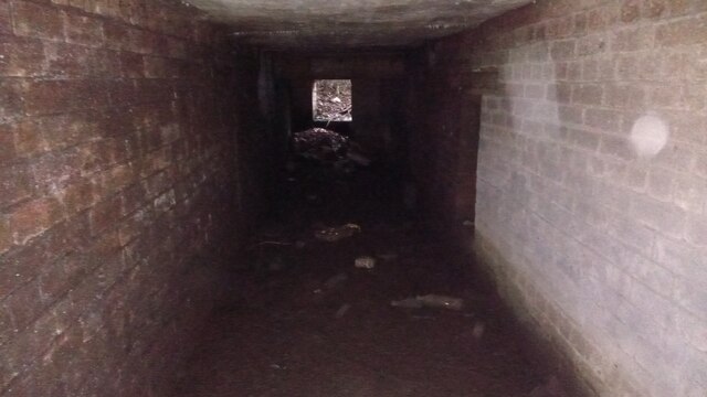
The winding engine house, a building rebuilt on the site of the electricity substation, and the short brick-lined tunnel that carried the Westwood haulage line under the B7015.
Redevelopment
The surviving buildings are used as commercial premises and a home or office.
Nearby mines
- Easter Breich No. 1 and 2 Pits — 0.4 miles (0.7 km) E
- Mid Breich No. 4 Pit — 0.4 miles (0.7 km) S
- Westwood No. 1 and 2 Pits — 0.6 miles (0.9 km) SE
- Westwood No. 30 Pit — 0.6 miles (0.9 km) SE
- Seafield No. 3 Mine — 0.7 miles (1.1 km) N
Straight-line distance, within 9 miles (15 km). Show on the map.
Further reading
The Museum of the Scottish Shale Oil Industry's page on the pits, with production figures, seam sections, archive photographs and newspaper extracts.
View sourceSources
- (secondary) Breich No. 1 & 2 pits (Scottish Shale, Museum of the Scottish Shale Oil Industry) — Museum of the Scottish Shale Oil Industry
- (secondary) Photo - pithead buildings at Breich, LVSAV2019.058 (Scottish Shale) — Museum of the Scottish Shale Oil Industry
- (primary) BGS mine plan: BREICH NO.1 2 3, Broxburn, abandoned 1927 — British Geological Survey
- (observational) Short Tunnel under B7015 (Geograph 6937743, Ian Dodds, 2021) — Geograph
- (primary) Mid Breich (Oil shale) (Durham Mining Museum) — Durham Mining Museum
- (primary) BGS / Mining Remediation Authority mine plan 21939285: Mid-Breich, Broxburn shale, abandoned 1961 — British Geological Survey
- (primary) BGS / Mining Remediation Authority mine plan 21939283: Mid-Breich, Dunnet Shale, abandoned 1961 — British Geological Survey
Record created: 5 November 2026 · Last researched: 6 November 2026