 MineArchive
Tintern Quarry
| Location | Above the River Wye opposite Tintern, near Tidenham, Forest of Dean, Gloucestershire — 51.6794, -2.6581 (exact) |
|---|---|
| Commodity | Limestone |
| Type | Quarry |
| Worked | 1931–1981 |
| Maximum depth | Unknown. |
Overview
A limestone quarry on the Gloucestershire side of the River Wye, opposite Tintern, whose ballast trains kept the southern end of the Wye Valley Railway working until December 1981, nearly eighteen years after the line closed to other goods.
History
Tintern Quarry lies in the Forest of Dean district of Gloucestershire, on the opposite side of the River Wye from the village of Tintern and just north of the northern portal of Tidenham tunnel, about two miles from the junction of the Wye Valley Railway with the main line. One account says it worked from 1931 to 1981; another describes it as served by the Wye Valley Railway from the line's opening in 1876 until it closed in 1981.
Limestone ballast from the quarry was the largest freight handled at Tintern station. Empty wagons were left at the quarry and the loaded ones taken to the Tintern sidings, to be collected by the returning goods train. When the Wye Valley Railway closed to goods in January 1964, the southern part of the line, including the 1,188-yard Tidenham tunnel, was kept as a private siding to serve Tintern and Dayhouse quarries. Open wagons gave way to 'dogfish' ballast hoppers loaded under the quarry's hoppers; in the late 1970s and early 1980s a class 37 locomotive brought about twenty of them at a time, leaving half at Tidenham before running through the tunnel to Tintern. The last train through the tunnel to Tintern Quarry ran in December 1981. The quarry is now disused.
Geology
Limestone; the Tidenham tunnel immediately to the south was cut mainly through Carboniferous limestone.
Workings
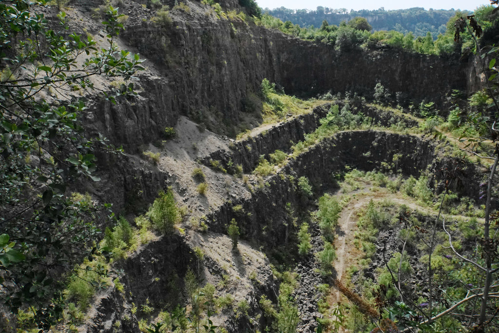
A large hillside quarry worked in terraces, with loading hoppers over rail sidings reached through Tidenham tunnel.
Closure
Closed in 1981; the last ballast train through Tidenham tunnel to the quarry ran in December 1981.
What remains
Disused; the large hole it has made in the hillside is well screened from the surrounding country.
Quarry terraces and faces, and the track that led down to the former railway loading point.
Redevelopment
Unknown.
Nearby mines
- Norchard Colliery — 6.2 miles (10.0 km) NE, Forest of Dean
- Clearwell Caves — 6.6 miles (10.6 km) N
- Saint Vincent's Colliery — 7.0 miles (11.3 km) NE, Forest of Dean
- Princess Royal Colliery — 7.2 miles (11.6 km) NE, Forest of Dean
- Dark Hill Colliery — 7.6 miles (12.2 km) N
Straight-line distance, within 9 miles (15 km). Show on the map.
What's uncertain
Points where sources disagree or the record could not be settled; both accounts are kept. All open questions in the archive.
- Worked from 1931 to 1981. (disputed) 2
- Served by the Wye Valley Railway from 1876 until it closed in 1981. (disputed) 1
Recorded claims
Individual factual claims, each attached to the source(s) that support it below. Where sources disagree, both are kept.
- The quarry lies opposite Tintern, just north of the northern portal of Tidenham tunnel, about two miles from the Wye Valley Railway's main-line junction. 1,2
- Worked from 1931 to 1981. (disputed) 2
- Served by the Wye Valley Railway from 1876 until it closed in 1981. (disputed) 1
- Limestone ballast from the quarry was the largest freight handled at Tintern station. 3
- After the railway closed to goods in January 1964 the southern section and Tidenham tunnel stayed open as a private siding for Tintern and Dayhouse quarries; the last train to Tintern Quarry ran in December 1981. 2,4
- Ballast was loaded into 'dogfish' wagons under hoppers at the quarry. 2
- The quarry is now disused. 1,5
Sources
- (secondary) Tintern Quarry — Wikipedia
- (secondary) Quarry Traffic (History of the Wye Valley Railway) — Wye Valley Greenway
- (secondary) Freight (History of the Wye Valley Railway) — Wye Valley Greenway
- (secondary) Tidenham Tunnel — Forest of Dean Local History Society
- (observational) Tintern Quarry (Geograph 5970856) — Geograph
Record created: 17 October 2026 · Last researched: 17 October 2026