 MineArchive
Port Mulgrave Mine
| Location | Port Mulgrave, between Staithes and Runswick Bay, North Yorkshire — 54.5490, -0.7580 (approximate) |
|---|---|
| Commodity | Iron |
| Type | Ironstone |
| Worked | 1856–1870s |
| Maximum depth | Unknown. |
| Operators | Palmers Shipbuilding and Iron Company (1856–1934) |
Overview
A Rosedale Wyke ironstone mine opened by Sir Charles Palmer in 1856-57 alongside a purpose-built harbour, exporting ore to his Jarrow ironworks until richer seams at Grinkle, three miles east, were connected to the same workings by an extended tunnel.
History
Port Mulgrave Mine was opened in the Rosedale Wyke seam by the shipbuilder and ironmaster Sir Charles Palmer in 1856-57, alongside a purpose-built harbour at the settlement then renamed Port Mulgrave (after the local landowner, the Earl of Mulgrave) to avoid confusion with the better-known ironstone district of Rosedale in the North York Moors. Tunnelling into the cliff began in 1854, two years ahead of the harbour itself, and ironstone was shipped out to supply Palmers Shipbuilding and Iron Company at Jarrow on the Tyne. By the 1870s the Rosedale Wyke seam was running out, and richer ground was found three miles to the east at Grinkle; rather than build a second harbour, the company extended the original tunnel a further mile to connect the two workings, so Grinkle's ore could still be shipped out through Port Mulgrave. A narrow-gauge railway was also built in 1875 to serve Grinkle directly. Port Mulgrave's own harbour remained a busy shipping point for around forty years, but became redundant by 1920 once a rail link and cheaper imported ironstone undercut it; Grinkle Mine itself was abandoned in 1934, and the harbour's remaining loading equipment was later sold for scrap, with its gantry destroyed by an accidental fire.
Geology
The Rosedale Wyke ironstone seam, worked on the Yorkshire coast from 1856-57.
Workings
Tunnelled into the cliff from 1854, working the Rosedale Wyke seam; from the 1870s extended a further mile to connect to the richer Grinkle workings three miles east, so both could be shipped out through the same harbour.
Closure
The original Rosedale Wyke workings were superseded in the 1870s once richer ground was found at Grinkle, though ore continued to be shipped out through the same harbour until it became redundant by 1920; the connected Grinkle Mine was abandoned in 1934.
What remains
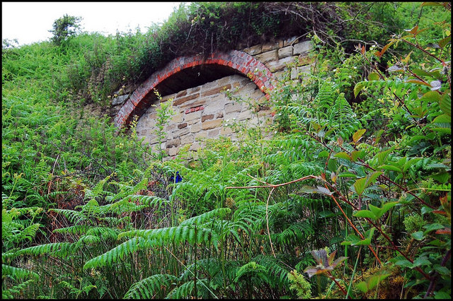
The blocked-up mine entrance survives around 50 feet above high water near the harbour remains; the harbour's own loading gantry was destroyed by fire after being sold for scrap.
A blocked-up mine entrance above the harbour, and the ruined remains of the harbour itself.
Related mines
- Grinkle Mine — Joined by the extended tunnel in the 1870s so Grinkle's ore could ship through Port Mulgrave.
Nearby mines
- Kettleness Alum Works — 2.1 miles (3.4 km) SE
- Boulby Mine — 2.7 miles (4.3 km) W
- Grinkle Mine — 2.6 miles (4.3 km) W
- Goldsborough Ironstone Mine — 3.1 miles (5.0 km) SE
- Boulby Alum Quarries — 3.3 miles (5.3 km) W
Straight-line distance, within 9 miles (15 km). Show on the map.
Recorded claims
Individual factual claims, each attached to the source(s) that support it below. Where sources disagree, both are kept.
- Port Mulgrave Mine and its harbour were opened by Sir Charles Palmer in 1856-57, tunnelling begun 1854, to supply ironstone to Palmers Shipbuilding and Iron Company at Jarrow. 1
- From the 1870s the original tunnel was extended a further mile to connect to the richer Grinkle ironstone workings three miles east, with a narrow-gauge railway also built to serve Grinkle in 1875. 2
- Hidden Teesside records the mine, begun by Charles Mark Palmer in the 1850s and first called Far Rosedale or Rosedale on the Coast, as working the Main Seam below sea level from shore shafts since lost to landslips and the Top Seam from upper workings whose shaft fed a wooden gantry to the harbour; the tunnel was extended in the 1870s to Grinkle by way of Dalehouse, and the bricked entrance served as a pillbox in the Second World War. 3
- Mining began in 1857 by shafts to the Main seam 60 feet below sea level; a new jetty of 1860 gave access to the Dogger seam, worked by drifts, and a wooden gantry ran from the entrance to the pier, where the tubs were tipped into bunkers for loading into the boats. 4
Photographs & further reading
A fuller history of the harbour and its connection to the Grinkle workings.
View sourceSources
- (secondary) Port Mulgrave, North Yorkshire — Wikipedia
- (secondary) Grinkle Mine — Wikipedia
- (secondary) Port Mulgrave Ironstone Mine (Hidden Teesside, 31 December 2012) — Hidden Teesside
- (observational) Mine Entrance, Port Mulgrave (Geograph, Mick Garratt, 2005) — Geograph Britain and Ireland
Record created: 1 September 2026 · Last researched: 24 September 2026