 MineArchive
Plump Hill Dolomite Quarry
| Location | Plump Hill, about a mile south of Mitcheldean, beside the A4136, Forest of Dean — 51.8519, -2.4928 (approximate) |
|---|---|
| Commodity | Limestone |
| Type | Quarry |
| Worked | Late 1800s–Early 1900s |
| Maximum depth | Unknown. |
Overview
A dolomite and limestone quarry on Plump Hill, a mile south of Mitcheldean, worked in the late nineteenth and early twentieth centuries for road metal and kiln lime, with a short tramway to a limekiln across the road. It has been a nature reserve since 1982.
History
Plump Hill, above Mitcheldean on the eastern side of the Forest of Dean, was one of the places where limestone was quarried extensively and burnt for lime. The Plump Hill Dolomite Quarry, beside what is now the A4136 between Cinderford and Mitcheldean, was worked extensively in the late nineteenth and early twentieth centuries for road metal and for kiln lime. In its last years of working, in the early 1900s, it was linked by a short tramway to a limekiln on the other side of the road; the kiln has long since gone.
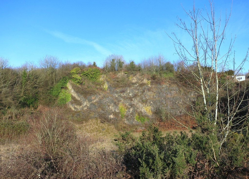
The quarry left three steep rock faces round a floor lying below the level of the road, the northern face up to about 100 feet high and still largely bare rock. They expose the Lower Dolomite Formation and, on the west side, a transition to the Crease limestone. Limestone grassland plants colonised the floor, among them autumn lady's-tresses, and in 1982 the quarry became a Gloucestershire Wildlife Trust nature reserve under an agreement with the Forestry Commission, enlarged in 1987. The Trust has since given up its management of the reserve.
Geology
Carboniferous Lower Dolomite Formation, with a transition to the Crease limestone on the west side.
Workings
An open quarry with three steep faces, the northern one up to about 100 feet; a short tramway to a limekiln across the road.
Closure
Last worked in the early 1900s.
What remains
Overgrown round the edges, with open limestone grassland on the quarry floor.
The quarry faces and floor; the limekiln has been removed.
Redevelopment
A nature reserve from 1982, a Key Wildlife Site in the Forest of Dean Local Plan.
Related mines
- Westbury Brook Ironstone Mine — Neighbouring workings on Plump Hill, south of Mitcheldean.
Nearby mines
- Westbury Brook Ironstone Mine — 0.3 miles (0.5 km) S
- Addis Hill Colliery — 0.7 miles (1.2 km) SW, Gloucestershire
- Speedwell Newbridge Colliery — 1.2 miles (1.9 km) W, Gloucestershire
- All Profit Colliery — 1.5 miles (2.4 km) SW, Gloucestershire
- Haywood Colliery — 1.6 miles (2.6 km) S, Gloucestershire
Straight-line distance, within 9 miles (15 km). Show on the map.
Recorded claims
Individual factual claims, each attached to the source(s) that support it below. Where sources disagree, both are kept.
- The quarry was worked extensively in the late nineteenth and early twentieth centuries for road metal and kiln lime. 1
- Last worked in the early 1900s, it was linked by a short tramway to a limekiln across the road. 2
- Limestone was quarried extensively and burnt on Plump Hill above Mitcheldean. 3
- The quarry became a nature reserve in 1982. 1,2
- The faces expose the Lower Dolomite Formation with a transition to the Crease limestone on the west side. 1
Photographs & further reading
The quarry's working, geology and flora.
View sourceThe quarry today, its tramway and limekiln, and its plants.
View sourceSources
- (secondary) Plump Hill Dolomite Quarry — Wikipedia
- (secondary) Plump Hill Dolomite Quarry Nature Reserve, Gloucestershire — UK Southwest
- (secondary) A History of the County of Gloucester: Volume 5, Bledisloe Hundred, St Briavels Hundred, the Forest of Dean — Industry — Victoria County History / British History Online
Record created: 4 October 2026 · Last researched: 4 October 2026