 MineArchive
Magheramorne Quarry
| Also known as | Magheramorne Cement Works |
|---|---|
| Location | Ballylig, Glynn, on the west shore of Larne Lough, County Antrim — 54.8210, -5.7571 (approximate, low confidence) |
| Commodities | Chalk, Limestone |
| Type | Quarry |
| Worked | Early 19th century–1980 (quarrying) |
| Maximum depth | Quarry faces up to 120 m high around a pit that is now deep and partly flooded. |
| Operators | Magheramorne Lime Company (?–1911), British Portland Cement Manufacturers (1911–1980) |
Overview
A vast chalk quarry on the western shore of Larne Lough, worked for lime from the early nineteenth century and then, from 1911, as the raw material for one of Ireland's largest cement works. To reach the chalk the quarrymen stripped away up to 100 m of overlying basalt and tipped it into the lough, building a peninsula of 70 hectares that is still there. Quarrying stopped in 1980 and the pit has flooded; its white-painted faces later stood in for the Wall in Game of Thrones.
History
Lime was burnt and shipped from Magheramorne on a considerable scale for more than a century before the cement industry arrived, the quarried rock being made into lime and exported to the Clyde for use in smelting. Quarrying was already under way when the Geological Survey of Ireland first visited in 1867, whose field notes record 20 m of chalk exposed and 14 m of overlying basalt already stripped. The Magheramorne Lime Company held the site until 1911.
In 1911 the British Portland Cement Manufacturers bought it — later Blue Circle — and began building a cement plant immediately. The first rotary kiln started in October 1914. The chalk was at first taken from the outcrop at the foot of the Antrim plateau, but was afterwards won by stripping back the basalt above it, which was tipped into Larne Lough. From 1925 the works also made calcium aluminate cement in a small water-cooled blast furnace fed with chalk, Antrim bauxite and lump coke, producing metallic iron as a by-product; the local bauxite's high iron content had already caused the aluminium industry to abandon it, and the product probably suffered by comparison with Lafarge's.
The plant was entirely electrically powered from the outset by its own turbo-generators, switching to purchased power from Larne around 1932. It stood on the Belfast–Larne coastal railway and had a deep-water wharf on the lough, so it could import and export in quantity. The start-up of Platin A2 in the Republic in 1977 forced a retrenchment; the escalating cost of quarrying made an upgrade to a competitive low-cost process unviable, and the last kiln stopped in 1980. The plant carried on grinding surplus clinker shipped from Plymstock until 1984, when shipping ready-ground cement proved cheaper, and then served as an import terminal until 2001.
Geology
The quarry cuts a full section through the Antrim succession. At the bottom, now submerged by the flooding, are some 3 m of calcareous mudstones, sandstones and green glauconitic sandstones of the Hibernian Greensands Formation. Above them 31 m of Late Santonian to Early Campanian chalk of the Ulster White Limestone Formation were measured — divided into the Cloghfin Sponge Beds, Creggan, Boheeshane, Larry Bane, Ballintoy and Glenarm chalks. The top surface of the chalk dips eastwards at 5 to 10 degrees and carries a pronounced karst topography that developed before the first lavas arrived: over about 400 m it changes from an almost flat surface into pinnacles and dolines with more than 15 m of relief, partly filled with Clay-with-Flints. Above all this lie five basalt flows of the Lower Basalt Formation of the Antrim Lava Group, about 70 m thick in total — the overburden the quarry had to remove to get at the chalk.
Geological setting: Sedimentary Beds and Seams (well documented example)
Workings
An enormous open pit with faces up to 120 m high. The economics rested on stripping: up to 100 m of basalt had to be taken off the chalk, and the waste was tipped into Larne Lough to form a spoil peninsula running about 1.5 km out from the shore and covering some 70 hectares of reclaimed ground. The works had four rotary kilns, the first running from October 1914 to April 1978, and raw milling plant that from 1953 included two 900 kW Vickers Armstrong ball mills installed in the quarry itself. Rail served the plant on the Belfast–Larne line and a deep-water wharf served it from the lough.
Closure
Chalk production ceased in 1980 when quarrying stopped and the last cement kiln was shut down. Grinding of imported clinker continued to 1984 and the site worked as a cement import terminal until 2001, shipping at the Magheramorne berth ending about 2002.
What remains
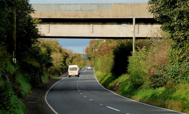
The quarry is deep and now partly flooded, with some of the raw milling plant standing half submerged. The production part of the plant has been cleared, though many features remain identifiable, and the cement handling plant still stands. The basalt waste peninsula reaching 1.5 km into Larne Lough is the most conspicuous result of the whole operation. The site is private and derelict, has been used for off-road driving, and the old structures are decaying; a 2020 exploration report describes the cement works buildings and machinery, the two flooded pools, the bridge carrying the site over the Larne road and railway, and a tunnel between the two halves.
Cement handling plant, derelict works buildings and machinery, half-submerged raw mills, the connecting bridge and tunnel between the two parts of the site, and the reclaimed basalt peninsula in the lough.
Redevelopment
A proposal to use the quarry for Belfast's waste was refused. Outline planning permission was obtained in September 2009 for redevelopment including an eco-village and a cycling centre in the quarry, with housing at the western end of the waste dump. The quarry was one of the principal Northern Ireland filming locations for Game of Thrones, its rock faces painted white to stand in for the Wall, with sets for Castle Black and Hardhome built into the natural contours; more recent proposals have envisaged opening the filming location as a visitor attraction.
Nearby mines
- Kilroot Salt Mine — 6.1 miles (9.8 km) S
Straight-line distance, within 9 miles (15 km). Show on the map.
Recorded claims
Individual factual claims, each attached to the source(s) that support it below. Where sources disagree, both are kept.
- Quarrying was already under way when the Geological Survey of Ireland recorded the site in 1867, its field notes giving 20 m of chalk exposed and 14 m of basalt already stripped from above it. 1
- British Portland Cement Manufacturers bought the site in 1911 and began building the cement plant immediately; the first rotary kiln ran from October 1914. 2
- The chalk was won by stripping back up to 100 m of overlying basalt, which was tipped into Larne Lough to form what is now a 70-hectare peninsula of reclaimed land extending about 1.5 km from the shore. 2,1
- From 1925 the works made calcium aluminate cement using a small water-cooled blast furnace fed with chalk, Antrim bauxite and lump coke, which produced metallic iron as a by-product and so reduced the iron content of the low-purity local bauxite. 2
- The last kiln stopped in 1980; the plant went on grinding surplus clinker from Plymstock until 1984 and then operated as an import terminal until 2001. 2
- Approximate total clinker production over the plant's life was 11.0 million tonnes, ranking it 37th among British and Irish cement works. 2
- The quarry exposes about 31 m of Ulster White Limestone Formation chalk over Hibernian Greensands, capped by five basalt flows of the Antrim Lava Group about 70 m thick, with a karst surface of pinnacles and dolines up to 15 m deep developed on the chalk before the lavas arrived. 1
- A proposal to use the quarry for Belfast's waste was refused; outline permission was granted in September 2009 for an eco-village and a cycling centre, with housing on the reclaimed waste ground. 1,3
Photographs & further reading
The geological conservation account of the site, describing the chalk members exposed, the buried karst surface on top of the chalk and the Clay-with-Flints filling its potholes.
View sourceA photographic account of what is left: the cement works buildings and machinery, the flooded pools, the bridge over the Larne road and railway, and the tunnel linking the two halves of the site.
View sourceA kiln-by-kiln technical history of the cement works — dimensions, operating dates, fuel, output and heat consumption for each of the four rotary kilns from 1914 to 1978.
View sourceSources
- (primary) Magheramorne Quarry, Larne — Clay-with-Flints (Earth Science Conservation Review) — Earth Science Conservation Review, National Museums NI
- (secondary) Magheramorne (Cement Plants and Kilns in Britain and Ireland) — Cement Plants and Kilns in Britain and Ireland
- (secondary) Magheramorne — Wikipedia
- (observational) Magheramorne Quarry, Co. Antrim, June 2020 — 28DaysLater
Record created: 3 September 2026 · Last researched: 3 September 2026