 MineArchive
Llanddulas Quarry
| Location | Llanddulas, Conwy — 53.2892, -3.6522 (exact) |
|---|---|
| Commodity | Limestone |
| Type | Quarry |
| Worked | By 1822–1990s |
A coastal limestone quarry at Llanddulas on the North Wales coast, served by jetties from 1822 and exporting millions of tonnes of stone overseas in the 1950s and 1960s.
Location
Recorded location. The large pin is this mine; the small round markers are the nearest mine on record. Click one for its page. View on full map
History
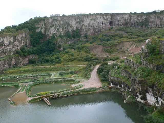
Llanddulas Quarry worked the limestone of Cefn-yr-Ogof on the North Wales coast, west of Llanddulas village. Quarrying at Llanddulas was first recorded in 1696, a little to the east, for building stone used locally and as far away as Liverpool. It went down to the shore by horse and cart and was loaded by hand into boats beached at low tide. The first jetty serving the quarry is recorded in 1822, connected by rail to the flooded quarry at the front of the site. As demand grew from 1839 the quarry moved inland and westward, and a new jetty went up in 1842 where the last one stood. The coast railway arrived in 1849, with a siding soon after, and in 1874 a lime kiln and a steam-driven crusher were built. Loaded tubs ran down to the jetty on a cable worked by gravity, the full ones hauling the empties back up.
As the chemical and iron-smelting industries took more of the stone, a concrete beach silo was built on the foreshore in 1940, and in 1947 the cable haulage gave way to a wooden jetty with conveyor belts. In the late 1950s and 1960s millions of tonnes of limestone went to Scandinavia, the Netherlands, Belgium and Germany, and the jetty was lengthened by 100 feet in the early 1980s, when the A55 was built. The jetty closed in 1993 by one account, or was used until 1997 for high-purity limestone for Belgian steelworks by another. By 2011 the site had no active quarrying and was used for landfill, and the jetty, conveyor and their buildings were recorded before demolition.
Geology
Carboniferous limestone of the Cefn-yr-Ogof hill.
Workings
A large open quarry with a flooded pit at its front, a crushing plant, and a cable incline and later a conveyor to the jetty.
Closure
Quarrying had stopped by 2011; the jetty closed in 1993 by one account and in 1997 by another.
What remains
Disused, beside a landfill site; the jetty has gone, while the quarry faces and the brickworks buildings within it survive.
Quarry faces, the flooded pit and silt lagoons, and brickworks buildings; the jetty, conveyor and beach silo were recorded in 2011 before demolition.
Redevelopment
Partly used for landfill.
Nearby mines
- Great Orme Copper Mines — 8.6 miles (13.8 km) W
Straight-line distance, within 9 miles (15 km).
Further reading
The Royal Commission's record: a history of the quarry and its jetties from 1696 to the demolition of the jetty in 2011.
View sourceA 2010 visit to the crushing plant and jetty, with the jetty's closure date.
View sourceSources
- (primary) Llanddulas Quarry, Abergele (Coflein, NPRN 414241) — RCAHMW
- (observational) Llanddulas Quarry and Jetty, March 2010 (28DaysLater) — 28DaysLater
- (observational) Cei Chwarel Llanddulas / Llanddulas Quarry Jetty (Geograph) — Geograph
- (observational) Llanddulas Limestone Quarry Works and P D Bricks, January 2018 (28DaysLater) — 28DaysLater
- (observational) Llanddulas Quarry (Geograph) — Geograph
Record created: 20 November 2026 · Last researched: 20 November 2026