 MineArchive
Llanbradach Quarry
| Also known as | Llanbradach Quarries |
|---|---|
| Location | Llanbradach, Rhymney Valley, Caerphilly — 51.5978, -3.2343 (approximate) |
| Commodity | Sandstone |
| Type | Stone |
| Worked | by 1905, possibly earlier |
| Maximum depth | An open quarry; no depth applies. |
Overview
Llanbradach Quarry is a disused Pennant sandstone quarry on the hillside about 2.5 km north of Caerphilly, photographed in work in 1905 and now a Site of Special Scientific Interest of 3.3 hectares. Its importance is palaeobotanical rather than industrial: the sandstones exposed by the quarrying contain permineralised plant remains preserving considerable detail of internal cell structure, and it is the only upper Westphalian permineralised flora known in western or central Europe. The quarry's own working history is not recorded. It is not the same feature as the small quarry that supplied Pennant sandstone to Llanbradach Colliery, which lies about 1.3 km to the north.
History
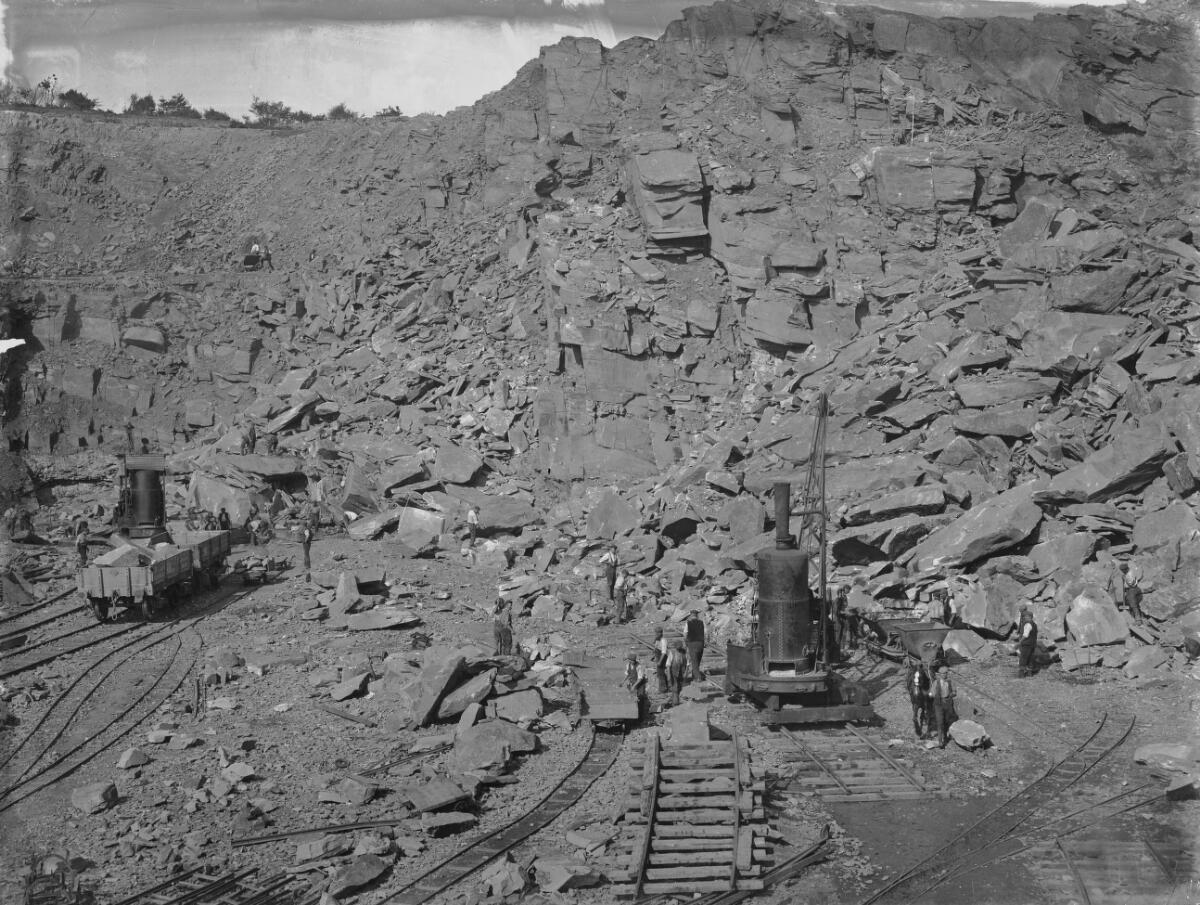
Very little of this quarry's working history has been recorded. A photograph in the Martin Ridley Collection, held by the National Library of Wales and taken in 1905, shows the quarries at work, so stone was being got here in the first decade of the twentieth century, in the period when the Rhymney Valley below was being transformed by Llanbradach Colliery and its Pennant sandstone buildings. No source names an operating company, gives a date for the quarry's opening or closure, records how many worked here, or states what the stone was used for. That gap is a fact about the surviving record rather than about the site, and it is left open here rather than filled by inference. What the quarry is documented for is what its working exposed. It was notified as a Site of Special Scientific Interest, the current notification dating from 5 June 1986, over 3.3 hectares, and is also recognised as a Regionally Important Geological and Geomorphological Site. It is today a well-known sport-climbing venue on the quarried faces.
Geology
The quarry works the Pennant sandstones of the Upper Carboniferous, the thick, hard sandstones that cap much of the South Wales Coalfield and gave the valleys their building stone. What makes this exposure nationally important is that it contains permineralised plant remains — fossils in which mineral matter has replaced the tissue closely enough to show considerable detail of the internal cell structure — and it is the only upper Westphalian permineralised flora to be found in western or central Europe. The standard of preservation varies markedly across the site, with specimens showing different degrees of permineralisation, which is itself of scientific value as a guide to how this kind of preservation comes about.
Geological setting: Sedimentary Beds and Seams (well documented example)
Workings
An open quarry cut into the hillside, leaving the tall faces that are now climbed. Nothing is recorded of its working methods, plant or transport arrangements; the 1905 photograph is the only direct record of it at work.
Closure
The closure date is not known. The quarry was disused by the time of its notification as a Site of Special Scientific Interest in 1986.
What remains
Disused and notified as a Site of Special Scientific Interest of 3.3 hectares, also recognised as a Regionally Important Geological and Geomorphological Site. The quarried faces are in regular use as a sport-climbing venue.
Redevelopment
None. The site's afterlife has been as a protected geological exposure and a climbing venue rather than as developed ground.
Nearby mines
- Llanbradach Colliery — 0.9 miles (1.4 km) N
- Bryngwyn Colliery — 1.0 miles (1.6 km) E
- Windsor Colliery — 1.5 miles (2.3 km) W
- Energlyn Colliery — 1.6 miles (2.6 km) S
- Rhos Llantwit Colliery — 1.6 miles (2.6 km) SE
Straight-line distance, within 9 miles (15 km). Show on the map.
What's uncertain
Points where sources disagree or the record could not be settled; both accounts are kept. All open questions in the archive.
- A photograph of 1905 in the National Library of Wales's Martin Ridley Collection shows the quarries in work. No source names an operator or gives an opening or closure date. (uncertain) 3
Recorded claims
Individual factual claims, each attached to the source(s) that support it below. Where sources disagree, both are kept.
- The quarry is a Site of Special Scientific Interest of 3.3 hectares at ST 146 895, the current notification dating from 5 June 1986, designated for its geological and geomorphological value and also recognised as a Regionally Important Geological and Geomorphological Site. 1,2
- The Pennant sandstones exposed here contain permineralised plant remains showing considerable detail of internal cell structure, and it is the only upper Westphalian permineralised flora found in western or central Europe. 1
- The standard of preservation varies considerably across the site, with specimens showing differing degrees of permineralisation, which provides a guide to how this type of preservation occurs. 1
- A photograph of 1905 in the National Library of Wales's Martin Ridley Collection shows the quarries in work. No source names an operator or gives an opening or closure date. (uncertain) 3
- This quarry is not the small quarry that supplied Pennant sandstone for Llanbradach Colliery's buildings and revetment walls: the colliery and its quarry lie at ST 1485 9085, about 1.3 km north of this site. 1,4
Photographs & further reading
Entry NH5.7 reproduces the Llanbradach Quarry SSSI description in full, with the grid reference, area and notification date, and explains what the permineralised flora is and why the varying quality of its preservation is itself scientifically useful.
View sourceSources
- (primary) Local Development Plan Appendix 5: Statutory Protected Sites for Biodiversity Conservation (NH5.7 Llanbradach Quarry) — Caerphilly County Borough Council
- (secondary) Llanbradach Quarry — Wikipedia
- (primary) Llanbradach Quarries, photograph, c.1905 (Martin Ridley Collection) — National Library of Wales, via Wikimedia Commons
- (secondary) Llanbradach Colliery, Llanbradach (NPRN 85050) — Royal Commission on the Ancient and Historical Monuments of Wales
.jpg)
Record created: 3 September 2026 · Last researched: 4 September 2026