 MineArchive
Hangman's Wood Deneholes
| Location | Little Thurrock, near Grays, Essex — 51.4813, 0.3540 (approximate) |
|---|---|
| Commodity | Chalk |
| Type | Mineral |
| Worked | Medieval or post-medieval (exact date disputed)–By the 19th century |
| Maximum depth | Shafts around 5 feet in diameter descending roughly 20 metres to chalk |
Overview
Over 70 narrow shafts sunk through sand into the chalk below at Little Thurrock, most likely dug to extract marl for improving farmland rather than as a building-stone quarry — their true age has been debated since at least the 19th century, and the survivors are now one of Essex's most important bat hibernation sites.
History
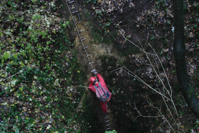
Deneholes are best understood as agricultural chalk mines rather than building-stone quarries: their narrow shafts deliberately minimised the loss of productive farmland surface compared with open-cast extraction, while reaching chalk deep enough that its mineral content had not been leached out by groundwater the way shallower deposits' had, making it more valuable as marl to spread on fields. Historic England dates the Hangman's Wood examples as medieval or post-medieval. A Victorian folk tradition dubbed them 'Cunobeline's gold mines', after the Iron Age British king Cunobelinus, though no evidence supports any such origin. Over 70 deneholes were recorded in the wood at one time, concentrated to its northern part; most now survive only as shallow dips in the ground where they have collapsed or been deliberately filled in. The Essex Field Club carried out systematic investigation and excavation of the site in 1884 and 1887, and in the 1880s its members dug connecting tunnels between some of the chambers. Historically, unmarked deneholes posed a real danger to unwary passers-by, livestock, and children who lit fires in the tunnels, leading many examples across Essex and Kent to be deliberately filled with rubbish for safety.
Geology
Shafts were sunk through the overlying Thanet Sand to reach the chalk beneath, typically around 5 feet in diameter and about 20 metres deep, opening out at the bottom into a cluster of chambers — commonly around six, radiating outward from the shaft base in a rough clover-leaf pattern designed to extract as much chalk as possible from underground while disturbing as little farmland surface as possible.
Workings
A narrow shaft was dug by hand down through sand and clay to reach the chalk, with chambers then excavated radiating outward from its base; chalk was hauled back up the shaft, most likely by windlass and basket, for spreading directly on nearby fields as marl.
Closure
Most deneholes fell out of active use by the 19th century as commercial fertilisers and other methods of soil improvement reduced the need for marling; the Essex Field Club's investigations of the 1880s came after the site's working life had effectively ended.
What remains
The deneholes are protected as a Site of Special Scientific Interest and Scheduled Monument, with access to the shafts themselves normally restricted (permission obtainable from the local council). They are now the most important underground bat hibernation site in Essex, home to brown long-eared, Natterer's and Daubenton's bats.
Most of the original shafts survive only as shallow depressions in the woodland floor; a small number of chambers remain intact and accessible below ground to those with permission.
Nearby mines
- Grays Thurrock Chalk Pit — 1.7 miles (2.7 km) W
- Eastern Quarry — 3.2 miles (5.1 km) SW, Kent
- Purfleet Chalk Pits — 4.5 miles (7.2 km) W
Straight-line distance, within 9 miles (15 km). Show on the map.
What's uncertain
Points where sources disagree or the record could not be settled; both accounts are kept. All open questions in the archive.
- The shafts were sometimes known as 'Cunobeline's gold mines', a folk name linking them to the Iron Age British king Cunobelinus, though no evidence supports this origin. (disputed) 2
Recorded claims
Individual factual claims, each attached to the source(s) that support it below. Where sources disagree, both are kept.
- Deneholes are now generally understood to have been dug to extract marl — chalk spread on fields to improve heavy clay soil — with their narrow shafts deliberately minimising the loss of productive farmland surface compared with open-cast extraction. 1
- Over 70 deneholes were recorded in Hangman's Wood at one time, concentrated to the north of the wood; most now survive only as shallow dips in the ground where they have collapsed or been filled. 2
- The Essex Field Club carried out systematic investigation and excavation of the deneholes in 1884 and 1887. 2,3
- The shafts were sometimes known as 'Cunobeline's gold mines', a folk name linking them to the Iron Age British king Cunobelinus, though no evidence supports this origin. (disputed) 2
- The deneholes are now the most important underground hibernation site for bats in Essex, home to brown long-eared, Natterer's and Daubenton's bats. 2
Photographs & further reading
An observational account and photoset of the underground chambers.
View sourceSources
- (secondary) Three agricultural Chalk Mines in north-west Kent — Kent Archaeological Society
- (secondary) Hangman's Wood and Deneholes — Wikipedia
- (secondary) Geology Site Account: Hangmans Wood Deneholes — Essex Field Club
- (primary) Descending a denehole at Hangman's Wood, West Thurrock, Essex — BGS Geoheritage
Record created: 22 August 2026 · Last researched: 22 August 2026